- Catalogs
- VideoDrone
- GeoDrone PPK
GeoDrone PPK

GeoDrone PPK
Catalog excerpts
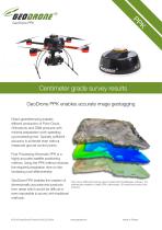
K Centimeter grade survey results GeoDrone PPK enables accurate image geotagging Direct georeferencing enables efficient production of Point Cloud, Orthophoto and DSM products with minimal preparation work speeding up processing time. Typically sufficient accuracy is achieved even without measured ground control points. Post Processing Kinematic PPK is a highly accurate satellite positioning method. Using the PPK method reduces the required preparation time on site increasing cost-effectiveness. GeoDrone PPK enables the creation of dimensionally accurate end products from areas which would be difficult or even impossible to survey with traditional methods. Point cloud, DSM and topology output created with Pix4DMapper software. The software also enables to create DTM, orthomosaic, 3D model and contour lines products.
Open the catalog to page 1
Global navigation satellites Drone (rover) Base station Reliable, flexible and easy Unlimited number of flights within base station’s vicinity The PPK system is more flexible than RTK systems as it allows longer distance from the base station, it is more reliable, accurate and easier to use. The system records both the image 1. Create a flight plan 2. Setup base station 4. Load & process data capture time and the GNSS data with microsecond accuracy to the internal memory, so there is no need for uninterrupted radio communication to provide correction data. Based on GeoDrone PPK and Base Station...
Open the catalog to page 2
No more impossible survey areas GeoDrone PPK enables mapping and land survey with high accuracy in challenging environments and regions. Accurate image positioning data produces consistent, reliable and survey grade products. The absolute accuracy achieved by the PPK method depends also on the rover’s distance from the base station, the accuracy of the base station’s location and the camera system used and its calibration. The PPK method enables after the flight also the calculation of more accurate location for your base station. Ground Control Points GCP Accuracy Error X Error Y Error Z Verified/...
Open the catalog to page 3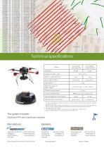
Technical specifications Feature 1. Accuracy is influenced by atmospheric conditions, amount of signal multipath, satellite geometry, availability and quality of correction. 2. Requires at least 5 valid satellites and GeoDrone PPK use according to the instructions. High multipath, high PDOP (> 4) and significant changes in the atmosphere during the operation will weaken the result. 3. The base station is not included. 4. PPK method needs high-quality correction data from the base station in RINEX format. 5. GeoDrone PPK is suitable for use with VideoDrone 16Ah battery only. GeoDrone PPK and VideoDrone...
Open the catalog to page 4All VideoDrone catalogs and technical brochures
 GeoDrone® X4L
2 Pages
 VideoDrone Innovation v5
4 Pages