
- Catalogs
- UP - Caeli Via srl
- KUR-500v2


- Company
- Products
- Catalogs
- News & Trends
- Exhibitions
KUR-500v2
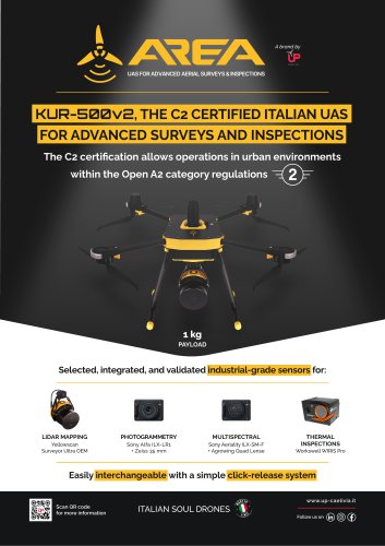
KUR-500v2
The KUR-500v2 is an Italian-made Unmanned Aerial System (UAS) certified under EASA C2, allowing operations in urban environments within the Open A2 category regulations. It is designed for advanced surveys and inspections with a focus on reliability, data accuracy, and long-term durability. The drone supports a maximum payload of 0.95 kg and has a maximum take-off mass of 3.99 kg. It features a hot-swap battery system, allowing for uninterrupted power during battery changes, and offers a maximum flight time of 23 minutes under optimal conditions.
The KUR-500v2 integrates industrial-grade sensors for various applications:
- LiDAR Mapping: Utilizes the Yellowscan Surveyor Ultra OEM and Hesai XT32-M2X laser scanner, capable of generating up to 1,920,000 points/sec with a precision of 3 cm and accuracy of 2.5 cm.
- Photogrammetry: Equipped with a Sony Alfa ILX-LR1 camera and Zeiss 35 mm lens, offering a 61 MP full-frame sensor with a wide ISO range and connectivity options.
- Multispectral Imaging: Features the Sony Aeriality ILX-SM-F with Agrowing Quad Lens, capturing a full spectrum from UV to infrared with multiple wavelength options.
- Thermal Inspections: Uses the Workswell WIRIS Pro for high-resolution thermal imaging, with real-time data analysis capabilities.
- Maximum dimensions: 920 x 810 x 380 mm
- Diagonal wheelbase: 660 mm
- Drone mass (no payload): 3.04 kg
- Propellers: Two-blade carbon fiber reinforced nylon, Ø 15”
- Motors: Brushless DC - 440 KV
- Batteries: 6S LiHV, 4500 mAh x2
- Ground Control Station: Herelink HD with a 5.46” touchscreen display
- Communication: 2.4 GHz ISM frequency band, range up to 20 km (FCC)
All data collected by the KUR-500v2 remains under the exclusive control of the operator, ensuring privacy and no mandatory cloud dependency.
For more information, visit www.up-caelivia.it or contact via phone at (+39) 0424 86 92 16 or email at [email protected].
Catalog excerpts
UAS FOR ADVANCED AERIAL SURVEYS & INSPECTIONS KUR-500v2, THE C2 CERTIFIED ITALIAN UAS FOR ADVANCED SURVEYS AND INSPECTIONS The C2 certification allows operations in urban environments within the Open A2 category regulations Selected, integrated, and validated industrial-grade sensors for: LiDAR MAPPING Yellowscan Surveyor Ultra OEM Sony Alfa ILX-LR1 + Zeiss 35 mm Sony Aeriality ILX-SM-F + Agrowing Quad Lense THERMAL INSPECTIONS Easily interchangeable with a simple click-release system Scan QR code for more information ITALIAN SOUL DRONES
Open the catalog to page 1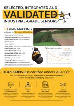
INDUSTRIAL-GRADE SENSORS LiDAR MAPPING YeUowscan Surveyor Ultra OEM • Laser Scanner: Hesai XT32-M2X • Max. Data Generated: 1,920,000 points/sec* • GNSS Inertial Solution: SBG Quanta Micro • Point Density: 60 pts/sqm @ loom AGL10 m/s • Scanner Field Of View: 360° x 40.3° • RGB Camera: Built-in (for coLorization purposes) Theoretical maximum of points with all shots yelding the maximum number of echoes. May vary depending on flight and survey conditions, and surveyed environment The C2 certification allows operations in urban environments within the Open A2 Category regulations Designed and manufactured...
Open the catalog to page 2
& PHOTOGRAMMETRYSony ALfa ILX-LR1 + Zeiss 35 mm • Sensor: 61 MP FuLL-Frame (35.7 mm x 23.8 mm), back-iLLuminated CMOS, with 14-bit RAW output • Lens: Interchangeable E-mount (compatible with Sony E-mount Lenses) • Shutter Speed: 30 s to 1/8000 s (mechanical and electronic shutter) • Continuous Shooting: 3 fps (at fuLL resolution) • Weight: Approx. 243 grams (body only, without Lens) • Connectivity: USB-C, Wi-Fi, Bluetooth, HDMI Type D, and support for wired remote control • Sensor: 61 MP FuLL-Frame (35,7 mm x 23,8 mm); FuLL Spectrum capability (captures the entire electromagnetic spectrum from...
Open the catalog to page 3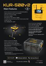
• Maximum Dimensions (propellers tip-to-tip): 920 x 810 x 380 mm • Diagonal Wheelbase (motor-to-motor): 660 mm • Drone Mass (no payload): 3.04 kg • Max Payload: ≤ 0.95 kg • MTOM (Maximum Take-Off Mass): ≤ 3.99 kg • Two-Blade Carbon Fiber Reinforced Nylon Folding Propellers: Ø 15” • Propeller pitch: 4.8” • Motors: Brushless DC - 440 KV • Ground Control Station: Herelink HD • Display: 5.46” Touch screen, 1080p • Frequency Band: 2.4 GHz ISM • Range: Up to 12 km (CE), Up to 20 km (FCC) • Telemetry: 2.4 GHz digital link, MAVlink protocol with AES-128 encryption • Connections: Micro USB for charging,...
Open the catalog to page 4All UP - Caeli Via srl catalogs and technical brochures
 Case Studies
8 Pages
- UAS
- Professional UAS
- Electric motor UAS
- Surveillance UAS
- Rotary wing UAS
- Inspection UAS
- Mapping UAS
- Civil defense UAS
- Quadrotor drone
- Agricultural UAS
- Search and rescue UAS
- Transport UAS
- Work jacket
- High-visibility jacket
- UAV for the construction industry
- Security UAV
- Topography UAV
- UAV for the mining industry
- Heavy lift UAV
- Waterproof jacket