- Catalogs
- ROBIN RADAR SYSTEMS B.V.
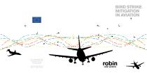
- Bird Strike Mitigation in Aviation
Bird Strike Mitigation in Aviation

Bird Strike Mitigation in Aviation
Robin Radar Systems provides advanced radar technology to mitigate bird strikes in aviation. This technology offers real-time, accurate information on bird movements near airports, enhancing safety and operational efficiency.
Radar Capabilities
The radar can detect birds up to 10 kilometers away, day and night, logging details such as size, speed, direction, and location. This complements human observation by providing continuous, automated monitoring.
Unique Tools & Benefits
- The Visualiser: Displays real-time bird movements on a map, allowing users to track flight paths and assess risk levels. It includes a playback mode for reviewing past events.
- The Mobile Viewer: Provides real-time alerts on tablet PCs in vehicles, highlighting high-risk birds entering critical zones. It also shows an activity grid for recent bird activity.
- The Remote Monitor: Allows remote monitoring and control of the radar system, performing automatic checks and enabling recovery from minor failures.
- The Report Viewer: Converts data into graphs for analysis, supporting habitat management and policy effectiveness discussions. It is web-based for remote access and integrates with advanced database tools.
Conclusion
Robin Radar's system enhances bird strike mitigation by providing comprehensive data and tools for analysis and decision-making, addressing safety and economic concerns in aviation.
Catalog excerpts
BIRD STRIKE MITIGATION IN AVIATION Robin Radar Systems BV Laan van Waalhaven 355 2497GM The Hague The Netherlands web
Open the catalog to page 1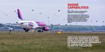
RADAR CAPABILITIES Radar offers unique complementary potential to human observation. Radar can detect birds at distances of up to 10 kilometres, all around, day and night. It automatically detects and logs hundreds of birds simultaneously, including their size, speed, direction, flight path and location in accurate metres. ‘WITH THIS TECHNOLOGY, ROBIN MEETS THE GROWING NEED FOR MORE ACCURATE AND REAL TIME INFORMATION ABOUT MOVEMENTS OF (LARGE) BIRDS IN THE VICINITY OF THE AIRPORT’ R2: Jan 2020 Jos Nijhuis, CEO of Schiphol Airpor
Open the catalog to page 2
UNIQUE TOOLS & BENEFITS Bird radar information is logged in real time and is used for data analysis over a given period of time. ROBIN’s specific software applications, created in close harmony with its users are described below. SEE BIRD MOVEMENTS IN REAL TIME (The “Visualiser”) The “Visualiser” displays bird movements on a map in real time. Users can orientate by using a Google background or a customized map with important landmarks and are able to zoom in on a specific bird track that represents its flight path. These tracks have different colours to distinguish high-risk birds from low(er)-risk...
Open the catalog to page 3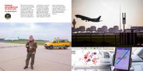
DISPLAY INFORMATION IN VEHICLES (The “Mobile Viewer”) Real time bird information can also be made available on commercial off-theshelf tablet PC’s for use in vehicles. The display can provide alerts if high-risk birds are about to enter a critical zone. This critical zone is a pre-defined area, customised in conjunction with the CAA and easy to modify if new insights are gained. In addition to individual birds and their flight paths, the Mobile Viewer can also display an activity grid, showing where there has been a lot of bird activity during the past 30 minutes. This provides a general insight...
Open the catalog to page 4
CONTROL THE RADAR FROM A DISTANCE (The “Remote Monitor”) The Remote Monitor is used to monitor the current state of the system. It automatically performs checks on various components of the system and shows the results in a graphical user interface. The tool is used to recover from minor system failures by restarting the applicable (sub-) system or even by remotely rebooting a server. ‘ROBIN RADAR HAS DEVELOPED A SYSTEM THAT DETECTS BIRDS AT GREAT DISTANCES’ Peter Hartman, (former) CEO o
Open the catalog to page 5
CONVERT DATA INTO GRAPHS (The “Report Viewer”) Bird strike mitigation at an international airport is a complex matter for the many stakeholders involved. This is one of the reasons why measuring, logging and reporting are important. To support this, ROBIN has developed a unique tool called the “Report Viewer”. All track data is stored in the PostgreSQL database. The tool generates basic graphs from the database. This not only involves track information, but also system uptime graphs and weather information. Furthermore, the tool enables database snapshotting for export to advanced COTS database...
Open the catalog to page 6All ROBIN RADAR SYSTEMS B.V. catalogs and technical brochures
 Datasheet - MAX®
2 Pages
 Datasheet - ELVIRA®
2 Pages
 Datasheet - IRIS®
2 Pages
 Drone Detection
13 Pages
