
Catalog excerpts

BIRD AND DRONE DETECTION PROTECTING MILITARY ASSETS
Open the catalog to page 1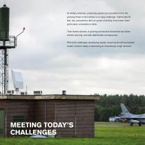
At military airbases, protecting assets and operations from the growing threat of bird strikes is no easy challenge. Fighter-jets fly fast, low, and perform tens of cycles of activity; that makes them particularly vulnerable to birds. Then there’s drones. A growing and elusive threat that can strike without warning, and with detrimental consequence. With both challenges developing rapidly, ensuring aircraft and assets remain mission-ready is becoming an increasingly tough demand. MEETING TODAY’S CHALLENGE
Open the catalog to page 3
Birds: Mitigating the Threat Managing wildlife and habitation on and surrounding airfields is absolutely paramount to successful and safe operations. That seems obvious. But, what’s less obvious is how to do that in a way which saves time, money and reduces risk as low as reasonably practicable (ALARP). This is made even more tricky by the fact that military aircraft are more at risk than civil aircraft. The cycle rate is high, and training and operations are often in the lower airspace, where 90% of bird strikes occur. Thankfully, Category A incidents are rare when it comes to bird...
Open the catalog to page 4
Drones: Mitigating the Threat Drones have become affordable, easy to obtain and simple to fly. They’re an innovative piece of technology for photography, prized by hobbyists and professionals alike, and are even used in the public sector, in delivery and agriculture. But the advanced and accessible technology that makes them popular is the very same reason why they are a formidable threat. They’re becoming smaller, faster, can fly higher and for longer. They’re elusive and extremely difficult to detect, classify and track. Traditional radar simply cannot see them. Mitigating the threat...
Open the catalog to page 5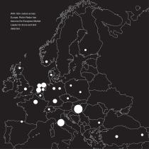
With 150+ radars across Europe, Robin Radar has become the European Market Leader for drone and bird detection.
Open the catalog to page 6
RADAR LOVE Our technology is installed across the globe, on numerous Unlike human observers, radars don’t need to rest, and terrains. But, it all started in The Netherlands. can see in all weather, day and night. They provide detailed insight in real-time and the ability to distinguish patterns and In cooperation with the Royal Netherlands Air Force, and predict the risk of bird strikes on a long-term basis. later, the European Space Agency (ESA), TNO began developing unique algorithms to use radar. It was clear the We know that time and resources are critical in a military technology had...
Open the catalog to page 7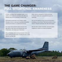
THE GAME CHANGER: FULL SITUATIONAL AWARENESS At Robin, we believe that knowledge is power. And a Radar tracks are displayed on intuitive interfaces position of full situational awareness is the difference to empower teams with unprecedented situational between being at risk, and being in control of risk. Full situational awareness at any airbase is game We know that detection is key, but only the first step in changing in terms of reducing the operational downtime neutralising a drone threat. That’s why’ve built our drone caused by bird strikes or a potential drone threat. radars to...
Open the catalog to page 8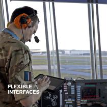
FLEXIBLE INTERFACES Source: Royal Air Force In the Control Tower at RAF
Open the catalog to page 10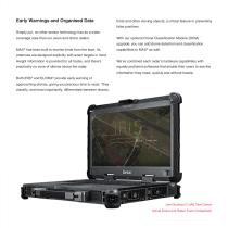
Early Warnings and Organised Data birds and other moving objects; a critical feature in preventing false positives. Simply put, no other sensor technology has as a wider coverage area than our avian and drone radars. With our optional Drone Classification Module (DCM) upgrade, you can add drone detection and classification MAX has been built to monitor birds from the start. Its ® capabilities to MAX® as well. antennas are designed explicitly with avian targets in mind. Height information is provided for all tracks, and there’s We’ve combined each radar’s hardware capabilities with...
Open the catalog to page 11
REALTIME CAPABILITY: DRONES Make Informed Decisions Quickly and with Accuracy Drone Viewer Customise Your Own Alarm Zones Awesome hardware demands software to match, and that’s As a user, you can define virtual zones depending on your why we’ve spared no effort to create Drone Viewer. own special use-cases. You can cause both visual and acoustic alarms to be triggered when a drone is detected It’s explicitly designed to give you fast, clear information and and classified. And for the more complex environments, you can be configured to suit your specific needs. can trigger alarms only when a...
Open the catalog to page 12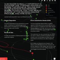
‘A 3D RADAR IS REALLY IMPORTANT IN COUNTER-UAS. IT SHOWS US EXACTLY WHERE THE DRONE IS, TELLING OUR OTHER SYSTEMS AND SENSORS WHERE TO FOCUS, TOO. THAT REALLY SPEEDS UP THE DECISION-MAKING PROCESS, AND TIME IS KEY.’ Lieutenant Colonel Rob Olthoff, Head of Joint Nucleus Counter UAS Remote Diagnostics Drone Classification Module (DCM) The system’s performance can be monitored from a remote The Drone Classification Module (DCM) is an optional location. If something is not working the way it should, upgrade for MAX® radars that can provide additional drone technical staff can immediately log...
Open the catalog to page 13
REALTIME CAPABILITY: BIRDS Know Exactly What’s Happening in Your Airspace Mobile Viewer Track Birds Accurately Mobile Viewer is designed for day-to-day operations. Tracking bird movements in real time has never been It empowers users out in the field to access real-time easier. You can select and zoom in on individual coloured information easily on tablets, which can be also be installed tracks, which represent actual bird flight paths. The colours distinguish between small, medium and large birds and flocks. A circle at the end of a track, varying in size depending Mobile Viewer also uses...
Open the catalog to page 14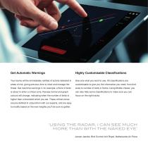
Highly Customisable Classifications Your teams will be immediately notified of activity detected in See only what you want to see. All classifications are areas of risk, giving precious time to react and manage the customisable to give you the information you need, from bird threat. Get real-time warnings if, for example, a flock of birds sizes to number of birds in flocks. Using Mobile Viewer, you is about to enter a critical zone. Runway funnel and graph can also hide some classifications to make sure you can colours will change, indicating when the number of birds is focus on the right...
Open the catalog to page 15All ROBIN RADAR SYSTEMS B.V. catalogs and technical brochures
-
Datasheet - MAX®
2 Pages
-
Datasheet - ELVIRA®
2 Pages
-
Datasheet - IRIS®
2 Pages
-
Drone Detection
13 Pages


