- Company
- Products
- Catalogs
- News & Trends
- Exhibitions
RiHYDRO

RiHYDRO
- Automatic classification of water surface points.
- Generation of a Water Surface Model (WSM) based on classified points.
- Refraction correction for points below the WSM.
- Support for various import and export formats for classification.
- Utilization of point clouds from different scanners to identify water surface points.
- Capability to import externally generated WSMs.
- Batch processing for unattended operation.
- Refraction correction is crucial for obtaining a geometrically correct point cloud, accounting for the laser beam's refraction at the air-water interface and the slower propagation speed within the water column.
- WSMs can be generated from laser data or imported if pre-existing.
- Users can specify the water's index of refraction and a depth bias value for refraction correction.
- Classification of Water Surface Points: Automatic classification is based on identifying areas with layers of water surface and subaqueous points. Manual adjustments can be made in critical areas.
- Generation of Water Surface Model (WSM): A grid-based WSM is generated for each flight strip, with options for handling standing water or riverine surfaces. Existing WSMs can also be imported.
- Shift of Targets Below Water Surface: Underwater targets are corrected for refraction using a tool that estimates a representative plane for each ray and calculates the correction vector.
Catalog excerpts

Airborne Data Processing Software AddOn for commercial hydrographic and bathymetric surveying • Automatic classification of water surface points • Generation of a water surface model (WSM) based on classified water surface points • Refraction correction of points below the water surface model (WSM) • Support of different import and export formats for classification purposes • Use point clouds from different scanners to identify water surface points • Import externally generated WSM • Processes a large number of files for unattended operation in batch mode • Smoothly integrated into RiPROCESS For smooth processing of scan data acquired with RIEGL Hydrography Laser Scanners the Airborne Data Processing Software AddOn RiHYDRO is offered as supplement to RiPROCESS. When processing bathymetric laser data, additional processing steps have to be applied since both, the laser beam’s refraction at the air-water interface and the lower propagation speed within the water column must be taken into account in order to obtain a geometrically correct point cloud. Those specific processing steps – usually called “refraction correction” – have to be carried out for each flight strip right after the standard ALS processing workflow. Refraction correction of the points below the air-water interface (i.e. both points on the water bed and within the water column) requires a geometric Water Surface Model (WSM). WSMs can be generated from the laser data by one of the tools offered with RiHYDRO. An alternative option is to import already existing water surface models. In the first case, the water surface points must be classified before. For this task, a specific point classification tool in RiHYDRO is provided, which allows classifying the points on horizontal water surfaces automatically. The user can specify the index of refraction of the water and also a depth bias value to be taken into account during refraction correction. visit our website www.riegl.com
Open the catalog to page 1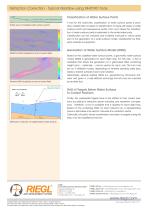
Refraction Correction - Typical Workflow using RiHYDRO Tools Classification of Water Surface Points Profile view of classified water surface points A tool for the automatic classification of water surface points is provided. Classification is based on identification of areas with layers of water surface points and subaqueous points. From such areas the classification of water surface points is extended to the entire water body. Classification can be checked and modified manually in critical areas prior to the generation of a water surface model. Classification by thirdparty software is supported....
Open the catalog to page 2All RIEGL LASER MEASUREMENT SYSTEMS GMBH catalogs and technical brochures
 RIEGL VQX-1 Wing Pod
4 Pages
 RIEGL VQ-780 II-S
8 Pages
 RiUNITE
4 Pages
 RIEGL VUX-120
8 Pages
 RIEGL VUX-240
6 Pages
 RIEGL miniVUX-SYS
4 Pages
 RIEGL miniVUX-1LR
4 Pages
 RIEGL miniVUX-3UAV
6 Pages
 RIEGL miniVUX-2UAV
4 Pages
 RIEGL miniVUX-1UAV
4 Pages
 RIEGL VUX-1UAV-22
6 Pages
 RiCOPTER with VUX-SYS
4 Pages
 RIEGL UAV Sensors & Systems
2 Pages
 RIEGL VQ-840-G
6 Pages
 RIEGL VQ-880-G II
6 Pages
 RIEGL VQ-880-GH
6 Pages
 PH-VUX
2 Pages
 RIEGL VPX-1
2 Pages
 RIEGL VP-1
2 Pages
 RIEGL VUX-SYS
4 Pages
 RIEGL VUX-1LR-22
6 Pages
 RIEGL VQ-1560 II-S
10 Pages
 RIEGL VQ-1560 II
10 Pages
 RIEGL VQ-780 II
8 Pages
 RIEGL LD05e-A30-PH67
5 Pages
 RiPROCESS
4 Pages
 RDBLib
2 Pages
 RiCOPTER-M
2 Pages
 RIEGL DR1560i
2 Pages
 RiVLib
4 Pages
 RiCOPTER
2 Pages
 RiACQUIRE
4 Pages
 RIEGL miniVUX-1DL
4 Pages
 LD05-A20 and LD05-A40
7 Pages
 LD05-A80
5 Pages
 RIEGL VQ-580 II
6 Pages
 RIEGL VQ-480 II
6 Pages
 RIEGL VQ-1560i-DW
10 Pages
 LD05e-A10
4 Pages
 LD05e-HT
4 Pages
 LD05-HTGF
13 Pages
 LD05-A10GF
10 Pages
 RiWaveLIB
2 Pages
 BathyCopter
4 Pages


- Aeronautical software
- Process software
- Maintenance software
- 3D software
- Cloud-based software
- Navigation software
- Test software
- Measurement software
- Drone software
- Data acquisition software
- Aeronautic laser scanner
- Non-contact laser scanner
- Measurement laser scanner
- Airborne laser scanner
- 3D laser scanner
- LIDAR software
- Pod
- Laser scanner software
- Drone laser scanner