- Catalogs
- RIEGL LASER MEASUREMENT SYSTEMS GMBH
- RIEGL VQ-880-G II
- Company
- Products
- Catalogs
- News & Trends
- Exhibitions
RIEGL VQ-880-G II

RIEGL VQ-880-G II
Overview: The RIEGL VQ-880-G II is a topo-bathymetric airborne laser scanning system designed for high-resolution surveying of underwater topography and topographic mapping. It features online waveform processing and full waveform recording capabilities.
Applications: This system is suitable for coastline and shallow water mapping, flood prevention data acquisition, aggradation zone measurement, habitat mapping, hydraulic engineering surveying, and hydro-archeological surveying.
System Specifications: The VQ-880-G II includes a green laser scanner with a measurement rate of up to 700 kHz and an IR laser scanner with a rate of up to 279 kHz. It offers high accuracy ranging through echo digitization and online waveform processing, with multiple-target capability. The system supports multiple-time-around processing for efficient mission planning and operation.
Technical Features: The system integrates an inertial navigation system and can accommodate up to two digital cameras. It is compatible with stabilized mounting platforms and features a rugged, dust- and splash-proof housing for long-term airborne operation.
Laser and Scanner Performance: The green laser channel operates at a wavelength of 532 nm, with a selectable beam divergence of 0.7 to 2.0 mrad. The IR laser channel operates at 1.064 nm. The system provides high-resolution 16-bit intensity information for each echo signal and supports practically unlimited targets per pulse.
IMU/GNSS and Camera Specifications: The system's IMU offers high accuracy with a roll and pitch accuracy of 0.0025° and a heading accuracy of 0.005°. It supports RGB and/or IR cameras with resolutions up to 100 MPixel CMOS or 80 MPixel CCD.
Operational Conditions: The system operates at altitudes up to 16,500 ft above mean sea level and within a temperature range of 0°C to +40°C. It requires a power supply of 18-32 V DC with a typical consumption of 330 W without cameras and 370 W with cameras.
Export and Compliance: The VQ-880-G II is classified as a dual-use good under the Wassenaar Arrangement and complies with various international laser safety standards.
Catalog excerpts

Topo-Bathymetric Airborne Laser Scanning System with Online Waveform Processing and Full Waveform Recording • designed for combined topographic and bathymetric airborne survey • green laser scanner with up to 700kHz measurement rate • IR laser scanner with up to 279kHz measurement rate and improved ranging performance • high accuracy ranging based on echo digitization and online waveform processing with multiple-target capability • multiple-time-around processing for straightforward mission planning and operation • concurrent full waveform output for all measurements for subsequent full waveform analysis for the green channel • high resolution due to high measurement rate • integrated inertial navigation system • up to two integrated digital cameras • compatibility with stabilized mounting platforms The design of the VQ-880-G topo-bathymetric airborne laser II scanning system allows flexible application of the integrated, factory-calibrated high-end GNSS/IMU system and of up to two cameras to meet specific requirements. Complemented by a RIEGL data recorder, the VQ-880-G LiDAR system can be installed on II various platforms in a straightforward way. The RIEGL VQ-880-G II carries out laser range measurements for high resolution surveying of underwater topography with a narrow, visible green laser beam, emitted from a powerful pulsed laser source. Subject to clarity, at this particular wavelength the laser beam penetrates water enabling measurement of submerged targets. The distance measurement is based on the time-of-flight measurement with very short laser pulses and subsequent echo digitization and online waveform processing. To handle target situations with most complex multiple echo signals, beside the online waveform processing the digitized echo waveforms can be stored on the RIEGL solid state data recorder for subsequent off-line waveform analysis. The laser beam is deflected in a circular scan pattern and hits the water surface at a nominally constant incidence angle. The VQ-880-G II comprises a high precision inertial measurement sensor for subsequent precise estimation of the instrument’s exact location and orientation. An infrared laser scanner is integrated to supplement the data gained by the green laser scanner. Up to two highresolution digital cameras provide RGB image data and/or IR image data. The rugged internal mechanical structure together with the dust- und splash water proof housing enables long-term operation on airborne platforms and is compatible with stabilizing mounts. Typical applications include • coastline and shallow water mapping • acquiring base data for flood prevention • measurement for aggradation zones • habitat mapping • surveying for hydraulic engineering • hydro-archeological-surveying visit our website www.rieg
Open the catalog to page 1
RIEGL VQ-880-G II Scan Pattern RIEGL VQ-880-G II Elements of Function and Operation mounting flange laser aperture 1064 nm channel laser aperture 532 nm channel connectors for power supply and data interface camera aperture 1 camera aperture 2 desiccant cartridges cooling air outlets carrying handles Copyright RIEGL Laser Measurement Systems GmbH © 2021– All rights reserved.
Open the catalog to page 2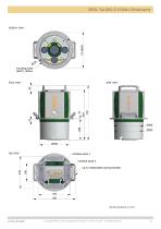
RIEGL VQ-880-G II Main Dimensions RIEGL VQ-880-G Housing Data Sheet Copyright RIEGL Laser Measurement Systems GmbH © 2021– All rights reserved.
Open the catalog to page 3
RIEGL VQ-880-G II Technical Data Export Classification The Topo-Bathymetric Airborne Laser Scanner VQ-880-G II has been designed and developed for commercial topographic, hydrographic and bathymetric surveying applications. Laser Product Classification Class 3B Laser Product according to IEC60825-1:2014 The VQ-880-G II is subject to export restrictions as set up by the Wassenaar Arrangement. It is classified as dual-use good according to position number 6A8j3 of the official Dual-Use-List to be found on site http://www.wassenaar.org. Within the European Union, Council Regulation (EC) No 428/2009...
Open the catalog to page 4
RIEGL VQ-880-G II Technical Data GREEN LASER CHANNEL Range Measurement Performance Measuring Principle time of flight measurement, echo signal digitization, online waveform processing, full waveform recording for post processing Hydrography Typ. Measurement Range 3) 1.5 Secchi depth for bright ground (≥80 %) 4) Topography (diffusely reflecting targets) natural targets ≥20 % natural targets ≥60 % Minimum Range Accuracy 9) 11) Precision 10) 11) Laser Pulse Repetition Rate Max. Effective Measurement Rate 5) Echo Signal Intensity Number of Targets per Pulse Laser Wavelength Laser Beam Divergence...
Open the catalog to page 5
RIEGL VQ-880-G II Technical Data IMU/GNSS Performance 1) 2) IMU Accuracy 3) Roll, Pitch 0.0025° Heading 0.005° IMU Sampling Rate 200 Hz Position Accuracy (typ.) horizontal / vertical <0.05 m / <0.1 m Integrated Digital Cameras 4) RGB and/or IR Camera Sensor Resolution Sensor Dimensions (diagonal) Focal Length of Camera Lens Field of View (FOV) Interface Data Storage Data Interfaces Configuration Scan Data Output GNSS Interface 6) General Technical Data Power Supply Input Voltage Power Consumption Main Dimensions (flange diameter x height) Weight Humidity Protection Class Scan Head Max. Flight...
Open the catalog to page 6All RIEGL LASER MEASUREMENT SYSTEMS GMBH catalogs and technical brochures
 RIEGL VQX-1 Wing Pod
4 Pages
 RIEGL VQ-780 II-S
8 Pages
 RiUNITE
4 Pages
 RIEGL VUX-120
8 Pages
 RIEGL VUX-240
6 Pages
 RIEGL miniVUX-SYS
4 Pages
 RIEGL miniVUX-1LR
4 Pages
 RIEGL miniVUX-3UAV
6 Pages
 RIEGL miniVUX-2UAV
4 Pages
 RIEGL miniVUX-1UAV
4 Pages
 RIEGL VUX-1UAV-22
6 Pages
 RiCOPTER with VUX-SYS
4 Pages
 RIEGL UAV Sensors & Systems
2 Pages
 RIEGL VQ-840-G
6 Pages
 RIEGL VQ-880-GH
6 Pages
 PH-VUX
2 Pages
 RIEGL VPX-1
2 Pages
 RIEGL VP-1
2 Pages
 RIEGL VUX-SYS
4 Pages
 RIEGL VUX-1LR-22
6 Pages
 RIEGL VQ-1560 II-S
10 Pages
 RIEGL VQ-1560 II
10 Pages
 RIEGL VQ-780 II
8 Pages
 RIEGL LD05e-A30-PH67
5 Pages
 RiPROCESS
4 Pages
 RDBLib
2 Pages
 RiCOPTER-M
2 Pages
 RIEGL DR1560i
2 Pages
 RiVLib
4 Pages
 RiCOPTER
2 Pages
 RiHYDRO
2 Pages
 RiACQUIRE
4 Pages
 RIEGL miniVUX-1DL
4 Pages
 LD05-A20 and LD05-A40
7 Pages
 LD05-A80
5 Pages
 RIEGL VQ-580 II
6 Pages
 RIEGL VQ-480 II
6 Pages
 RIEGL VQ-1560i-DW
10 Pages
 LD05e-A10
4 Pages
 LD05e-HT
4 Pages
 LD05-HTGF
13 Pages
 LD05-A10GF
10 Pages
 RiWaveLIB
2 Pages
 BathyCopter
4 Pages


- Aeronautical software
- Process software
- Maintenance software
- 3D software
- Cloud-based software
- Navigation software
- Test software
- Measurement software
- Drone software
- Data acquisition software
- Aeronautic laser scanner
- Non-contact laser scanner
- Measurement laser scanner
- 3D laser scanner
- LIDAR software
- Pod
- Laser scanner software
- Drone laser scanner