- Catalogs
- RIEGL LASER MEASUREMENT SYSTEMS GMBH
- RIEGL VQ-580 II
- Company
- Products
- Catalogs
- News & Trends
- Exhibitions
RIEGL VQ-580 II

RIEGL VQ-580 II
The RIEGL VQ-580 II is an advanced airborne laser scanning system designed for high-performance and user-friendly operation. It features a new design that reduces weight and allows for seamless integration into various platforms, including helicopters and small aircraft.
Specifications
The VQ-580 II utilizes RIEGL's Waveform-LiDAR technology, providing highly accurate point clouds and excellent vertical target resolution. It supports a measurement rate of up to 1,250,000 measurements per second and a wide field of view of 75°. The system is particularly effective for surveying applications such as corridor mapping, city modeling, and agriculture.
Key Features
- High laser pulse repetition rate up to 2MHz.
- Measurement rate up to 1,250,000 measurements/sec.
- Wide field of view of 75°.
- Interfaces for up to 5 optional cameras.
- Mechanical and electrical interface for IMU/GNSS integration.
- Compact and lightweight design.
Applications
- Corridor Mapping
- Agriculture & Forestry
- Glacier and Snowfield Mapping
- Moist Grassland Mapping
- City Modeling
Performance and Data Handling
The system offers a maximum measurement range and point density, with examples provided for different pulse rates and altitudes. Data storage options include a removable CFast® storage card and an integrated SSD.
Technical Data
- Laser Pulse Repetition Rate: Up to 2000 kHz.
- Max. Effective Measurement Rate: Up to 1,250,000 meas./sec.
- Laser Wavelength: Near infrared.
- Laser Beam Divergence: 0.25 mrad.
- Power Supply: 18 - 34 V DC.
- Weight: 9.9 kg without IMU/GNSS, 10.3 kg with IMU/GNSS.
- Protection Class: IP54.
Conclusion
The RIEGL VQ-580 II is a versatile and high-performance airborne laser scanning system suitable for a wide range of applications, offering advanced features and robust data handling capabilities.
Catalog excerpts

Waveform Processing Airborne Laser Scanning System • high accuracy ranging based on RIEGL Waveform-LiDAR technology • high laser pulse repetition rate up to 2MHz • measurement rate up to 1,250,000 measurements/sec • perfectly linear and parallel scan lines • wide field of view of 75° • excellently suited to measure on snow & ice • interfaces for up to 5 optional cameras • mechanical and electrical interface for IMU/GNSS integration • removeable storage card and integrated Solid State Disk (SSD) for data storage • compact, & lightweight design • compatible with stabilized platforms and even small hatches • seamless integration and compatibility with other RIEGL ALS systems and software packages In further development of the RIEGL VQ-580 Airborne Laser Scanner Series - the RIEGL VQ-580 II presents itself in a completly new design that successfully takes up the already proven qualities and leads them to a new standard of performance and user-friendliness. Its new sophisticated design allows to further reduce the overall weight and enables the seamless integration into stabilized platforms, e.g. standard gyromounts, and also into even small hatches. The scanner is well suited for the use in manned aircrafts like helicopters, small fixed-wing aircrafts, or ultra-light planes. Based on RIEGL's proven Waveform-LiDAR technology, the VQ-580 II provides highly accurate point clouds, excellent vertical target resolution, calibrated reflectance readings, and pulse shape deviation for unsurpassed information content on each single measurement. With a measurement rate of up to 1,250,000 measurements/second and an extremely wide field of view of 75°, the scanner offers itself as the first choice for airborne surveying applications like corridor mapping, city modeling, and agriculture & forestry. The laser wavelength makes it especially suited for measurements on ice and snow. An easy to remove CFast® storage card and an integrated Solid State Disk and/or the option for streaming the scan data via LAN TCP/IP interface are provided for data transfer and storage. vv:- ,v- : - visit our website www.riegl.com EiEGll SYSTEMS Typical applications include • Corridor Mapping • Agriculture & Forestry • Especially suited for Glacier Mapping and Snowfield Mapping • Moist Grassland Mapping • City Modeling ft) RIEGL iiT LASER MEASUREMENT SYSTEMS Airborne Laser Scanning
Open the catalog to page 1
Front View cooling inlet M8x1.25 - 6H threads, depth 9mm nitrogen_____ RIEGL VQ®-580II Installation Example RIEGL VQ-580 II installed on GSM-4000 stabilized platform to be used in a helicopter or fixed-wing aircraft 2 Copyright RIEGL Laser Measurement Systems GmbH © 2019- All rights reserved. Data Sheet
Open the catalog to page 2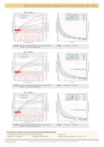
Maximum Measurement Range & Point Density RIEGL VQ®-580 II Example: VQ-580 II at 150,000 pulses/sec, laser power level 100% Altitude = 4,200 ft AGL, Speed 60 kn Results: Point Density ~ 1.55 pts/m² spacing point to point = spacing line to line spacing point to point ≠ spacing line to line Example: VQ-580 II at 300,000 pulses/sec, laser power level 100% Altitude = 3,000 ft AGL, Speed 60 kn Point Density ~ 4.33 pts/m² spacing point to point = spacing line to line spacing point to point ≠ spacing line to line Example: VQ-580 II at 600,000 pulses/sec, laser power level 100% Altitude = 3,200 ft AGL,...
Open the catalog to page 3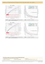
Maximum Measurement Range & Point Density RIEGL VQ®-580 II spacing point to point = spacing line to line spacing point to point ≠ spacing line to line Example: VQ-580 II at 1,200,000 pulses/sec, laser power level 100% Altitude = 2,300 ft AGL, Speed 60 kn Results: Point Density ~ 22.58 pts/m² spacing point to point = spacing line to line spacing point to point ≠ spacing line to line Example: VQ-580 II at 2,000,000 pulses/sec, laser power level 100% Altitude = 1,300 ft AGL, Speed 60 kn Point Density ~ 66.60 pts/m² The following conditions are assumed for the Operating Flight Altitude AGL • ambiguity...
Open the catalog to page 4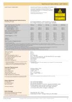
Laser Product Classification Class 3B Laser Product according to IEC 60825-1:2014 Measuring Principle The following clause applies for instruments delivered into the United States: Complies with 21 CFR 1040.10 and 1040.11 except for conformance with IEC 60825-1 Ed.3., as described in Laser Notice No. 56, dated May 8, 2019. The instrument must be used only in combination with the appropriate laser safety box. echo signal digitization, online waveform processing, time-of-flight measurement, multiple target capability Minimum Range Accuracy 7) 9) Precision 8) 9) Laser Pulse Repetition Rate 10) Max....
Open the catalog to page 5
General Technical Data Power Supply Input Voltage Power Consumption Main Dimensions (L x W x H) Weight without integrated IMU/GNSS with integrated IMU/GNSS Humidity Protection Class Max. Flight Altitude operating & not operating Temperature Range 18 - 34V DC typ. 110 W, max. 220 W 1 378 mm x 193 mm x 252 mm (without mounted carrying handles) 9.9 kg 10.3 kg non condensing IP54, dust-proof and splash-proof 18500 ft (5600 m) above MSL (Mean Sea Level) -5°C up to +40°C (operation) / -10°C up to +50°C (storage) Integrated IMU & GNSS (optional) 2) IMU Accuracy Roll, Pitch 0.015° Position Accuracy (typ.)...
Open the catalog to page 6All RIEGL LASER MEASUREMENT SYSTEMS GMBH catalogs and technical brochures
 RIEGL VQX-1 Wing Pod
4 Pages
 RIEGL VQ-780 II-S
8 Pages
 RiUNITE
4 Pages
 RIEGL VUX-120
8 Pages
 RIEGL VUX-240
6 Pages
 RIEGL miniVUX-SYS
4 Pages
 RIEGL miniVUX-1LR
4 Pages
 RIEGL miniVUX-3UAV
6 Pages
 RIEGL miniVUX-2UAV
4 Pages
 RIEGL miniVUX-1UAV
4 Pages
 RIEGL VUX-1UAV-22
6 Pages
 RiCOPTER with VUX-SYS
4 Pages
 RIEGL UAV Sensors & Systems
2 Pages
 RIEGL VQ-840-G
6 Pages
 RIEGL VQ-880-G II
6 Pages
 RIEGL VQ-880-GH
6 Pages
 PH-VUX
2 Pages
 RIEGL VPX-1
2 Pages
 RIEGL VP-1
2 Pages
 RIEGL VUX-SYS
4 Pages
 RIEGL VUX-1LR-22
6 Pages
 RIEGL VQ-1560 II-S
10 Pages
 RIEGL VQ-1560 II
10 Pages
 RIEGL VQ-780 II
8 Pages
 RIEGL LD05e-A30-PH67
5 Pages
 RiPROCESS
4 Pages
 RDBLib
2 Pages
 RiCOPTER-M
2 Pages
 RIEGL DR1560i
2 Pages
 RiVLib
4 Pages
 RiCOPTER
2 Pages
 RiHYDRO
2 Pages
 RiACQUIRE
4 Pages
 RIEGL miniVUX-1DL
4 Pages
 LD05-A20 and LD05-A40
7 Pages
 LD05-A80
5 Pages
 RIEGL VQ-480 II
6 Pages
 RIEGL VQ-1560i-DW
10 Pages
 LD05e-A10
4 Pages
 LD05e-HT
4 Pages
 LD05-HTGF
13 Pages
 LD05-A10GF
10 Pages
 RiWaveLIB
2 Pages
 BathyCopter
4 Pages


- Aeronautical software
- Process software
- Maintenance software
- 3D software
- Cloud-based software
- Navigation software
- Test software
- Measurement software
- Drone software
- Data acquisition software
- Aeronautic laser scanner
- Non-contact laser scanner
- Measurement laser scanner
- Airborne laser scanner
- 3D laser scanner
- LIDAR software
- Pod
- Laser scanner software
- Drone laser scanner