- Catalogs
- RIEGL LASER MEASUREMENT SYSTEMS GMBH
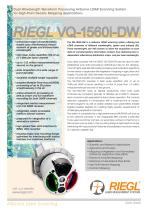
- RIEGL VQ-1560i-DW
- Company
- Products
- Catalogs
- News & Trends
- Exhibitions
RIEGL VQ-1560i-DW

RIEGL VQ-1560i-DW
The RIEGL VQ-1560i-DW is an advanced airborne LiDAR scanning system designed for high-point density mapping applications. It features dual LiDAR channels operating at green and infrared wavelengths, providing complementary data for enhanced target characterization and mapping.
- Dual LiDAR channels with green and infrared wavelengths.
- Laser pulse repetition rate up to 1 MHz per channel, totaling over 1.3 million measurements per second.
- Operational altitude up to 8300 ft, with flexibility for stand-alone channel operation.
- Integrated high-performance IMU/GNSS unit and optional cameras (150 MP RGB primary camera, thermal or NIR secondary camera).
- Optimized mounting flange for easy aircraft integration.
- Simultaneous measurements at dual wavelengths for enhanced data acquisition.
- Multiple-Time-Around (MTA) processing capability for up to 20 pulses.
- Online waveform processing and full waveform recording.
- High-speed fiber data interface for efficient data transfer.
- Scientific and research applications.
- Agriculture and forestry, including vegetation mapping and NDVI.
- Glacier and snowfield mapping.
- Mapping of lake sides, river banks, and high point density areas.
- Corridor mapping.
- Example configurations demonstrate varying point densities and area acquisition rates based on pulse repetition rates and laser power levels.
- Data includes operating flight altitudes, point densities, and area acquisition rates under different conditions.
- Minimal system components and cabling for quick installation in aircraft.
- Examples include installations in fixed-wing aircraft and gyro-stabilized platforms.
- Laser Product Classification: Class 3B according to IEC 60825-1:2014.
- Laser Wavelengths: Green (532 nm) and near infrared (1064 nm).
- Laser Pulse Repetition Rate: Up to 2 x 1000 kHz.
- Measurement Range: Varies with target reflectance and laser power settings, with maximum ranges specified for both 20% and 60% reflectance.
- Point Density: Can achieve up to 2 pts/m² at 500,000 pulses/sec.
- Operating Flight Altitude: Up to 15,500 ft AGL depending on conditions.
- Area Acquisition Rate: Varies with flight altitude and speed, with examples provided for different configurations.
- Swath Width: Dependent on flight altitude and field of view (FOV).
- Point Density: Affected by flight speed and altitude, with higher densities achievable at lower altitudes.
- Assumptions for Calculations: Include 20% overlap of flight strips, effective FOV of 58°, and average ambient brightness.
- Multiple-Time-Around (MTA) Processing: Used to resolve range ambiguities.
- Environmental Conditions: Performance may vary with ambient brightness and atmospheric visibility.
- Channel Selection Capability: Offers flexibility in operation by allowing selection between green and infrared channels.
- Export Restrictions: Subject to Wassenaar Arrangement and EU Council Regulation (EC) No 428/2009.
- Power Supply: 20 - 32 V DC with typical power consumption of 250 W.
- Weight: Approximately 60 kg without camera, 65 kg with optional components.
- Protection Class: IP54.
- Temperature Range: Operational from 0°C to +40°C, storage from -10°C to +50°C.
Catalog excerpts
Dual Wavelength Waveform Processing Airborne LiDAR Scanning System for High-Point Density Mapping Applications RIEGL VQ-1560i-DW ••enhanced target characterization based upon simultaneous measurements at green and infrared laser wavelengths ••high laser pulse repetition rate of up to 1 MHz per laser channel ••up to 1.33 million measurements per second on the ground ••data acquisition at a wide range of point densities ••excellent multiple target capability ••enables Multiple-Time-Around (MTA) processing of up to 20 pulses simultaneously in the air ••online waveform processing as well as smart and full waveform recording for both LiDAR channels ••integrated inertial measurement unit and GNSS receiver ••integrated, easily accessible medium format camera ••prepared for integration of a secondary camera ••high-speed fiber data interface to RIEGL data recorder ••housing shape and mounting flange optimized for interfacing with typical hatches and stabilized platforms The VQ-1560i-DW is a airborne LiDAR scanning system offering two LiDAR channels of different wavelengths, green and infrared (IR). These wavelengths are well chosen to allow the acquisition of scan data of complementary information content, thus delivering two independent reflectance distribution maps, one per laser wavelength. Scan data acquired with the RIEGL VQ-1560i-DW are the input for wellestablished scan data processing methods but also for the development of highly sophisticated data processing and evaluation algorithms for new areas of application like vegetation mapping in agriculture and forestry. Thus the VQ-1560i-DW offers innovative technology for commercial as well as scientific and research applications. The VQ-1560i-DW provides a laser pulse repetition rate of up to 1MHz per LiDAR channel, resulting in a total of more than 1.3 million measurements per second on the ground. The VQ-1560i-DW works at highest productivity when both LiDAR channels are combined, typically at altitudes up to 8300 ft. However, each channel is also prepared for stand-alone operation. This channel selection capability in combination with a matched line of measurement programs as well as widely variable scan parameters enable highest possible flexibility for meeting highly specific requirements of challenging application scenarios. The system is completed by a high performance IMU/GNSS unit and up to two optional cameras. A 150 megapixels RBG camera is intended to be used as primary camera, as secondary camera a thermal or a NIR camera can be built in. The mounting flange is optimized for simple interfacing with typical aircraft hatches and stabilized mounts by means of a specific adapter ring. Applications: •• cientific and Research Applications S ••Agriculture and Forestry ••Mapping of Vegetation and Normalized Difference Vegetation Index (NDVI) ••Glacier & Snowfield Mapping ••Mapping of Lake Sides & River Banks ••High Point Density Mapping ••Corridor Map
Open the catalog to page 1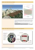
RIEGL VQ-1560i-DW Scan Pattern Each channel delivers straight parallel scan lines. The scan lines of the two channels are tilted against each other by 28 degrees providing an optimum distribution of the measurements on the ground invariant to changes in terrain height. Tilt Angle of Scan Lines Forward/Backward Scan Angle in Non-Nadir Direction RIEGL VQ-1560i-DW Elements of Function and Operation aperture of primary camera (RGB) aperture of IR laser channel mounting flange aperture of green laser channel aperture of secondary camera connectors for power supply and data interface desiccant cartridges...
Open the catalog to page 2
Data Sheet Copyright RIEGL Laser Measurement Systems GmbH © 2019- All rights reserved. 3
Open the catalog to page 3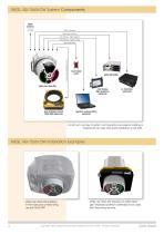
RIEGL VQ-1560i-DW System Components GNSS antenna USB 3.0 interface high speed interface LAN interface - flight guidance LAN interface - system control control for gyro-stabilized mount laser safety switch laser safety switch RIEGL VQ-1560i-DW pilot display flight guidance (optional) gyro-stabilized mount GSM-4000 (optional) operator working station (optional) A minimum number of system components and external cabling is required for an easy and quick installation in aircrafts. RIEGL VQ-1560i-DW Installation Examples RIEGL VQ-1560i-DW installed in the nose pod of fixed-wing aircraft DA42 MPP RIEGL...
Open the catalog to page 4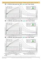
Measurement Range & Point Density - Green and IR Laser Channel PRR = 2x700 kHz, laser power level 100%, green and IR laser channel [m] white marble coniferious trees quartz sand wood beam trees, grass, terra cotta deciduous trees terra cotta concrete cliffs, sand, masonry TYPICAL ENOHD white plaster work, limestone Swath Width 7000 Total Point Density [pts/m2] Operating Flight Altitude AGL Flight Altitude AGL Swath Width 35 Area Acquisition Rate [km²/h] @ visibility 40 km @ visibility 23 km @ visibility 15 km Target Reflectance [%] Example: VQ-1560i-DW at 2 x 700,000 pulses/sec, laser power level...
Open the catalog to page 5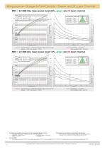
Measurement Range & Point Density - Green and IR Laser Channel PRR = 2x1000 kHz, laser power level 25%, green and IR laser channel [m] @ visibility 40 km @ visibility 23 km @ visibility 15 km deciduous trees terra cotta concrete wood beam trees, grass, terra cotta TYPICAL ENOHD cliffs, sand, masonry white plaster work, limestone white marble Swath Width Total Point Density [pts/m2] Operating Flight Altitude AGL coniferious trees quartz sand Area Acquisition Rate [km²/h] Flight Altitude AGL Swath Width Target Reflectance [%] Example: VQ-1560i-DW at 2 x 1,000,000 pulses/sec, laser power level 25%...
Open the catalog to page 6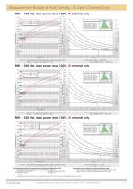
Measurement Range & Point Density - IR Laser Channel Only PRR = 150 kHz, laser power level 100%, IR channel only [m] Operating Flight Altitude AGL TYPICAL ENOHD cliffs, sand, masonry deciduous trees terra cotta coniferious trees white plaster work, limestone Flight Altitude AGL Swath Width 1.75 Area Acquisition Rate [km²/h] @ visibility 40 km @ visibility 23 km @ visibility 15 km Target Reflectance [%] Example: VQ-1560i-DW at 150,000 pulses/sec, laser power level 100% Altitude = 15,000 ft AGL, Speed = 150 kn Results: Point Density ~ 0.25 pts/m² Area Acquisition Rate ~ 1130 km²/h PRR = 250 kHz,...
Open the catalog to page 7All RIEGL LASER MEASUREMENT SYSTEMS GMBH catalogs and technical brochures
 RIEGL VQX-1 Wing Pod
4 Pages
 RIEGL VQ-780 II-S
8 Pages
 RiUNITE
4 Pages
 RIEGL VUX-120
8 Pages
 RIEGL VUX-240
6 Pages
 RIEGL miniVUX-SYS
4 Pages
 RIEGL miniVUX-1LR
4 Pages
 RIEGL miniVUX-3UAV
6 Pages
 RIEGL miniVUX-2UAV
4 Pages
 RIEGL miniVUX-1UAV
4 Pages
 RIEGL VUX-1UAV-22
6 Pages
 RiCOPTER with VUX-SYS
4 Pages
 RIEGL UAV Sensors & Systems
2 Pages
 RIEGL VQ-840-G
6 Pages
 RIEGL VQ-880-G II
6 Pages
 RIEGL VQ-880-GH
6 Pages
 PH-VUX
2 Pages
 RIEGL VPX-1
2 Pages
 RIEGL VP-1
2 Pages
 RIEGL VUX-SYS
4 Pages
 RIEGL VUX-1LR-22
6 Pages
 RIEGL VQ-1560 II-S
10 Pages
 RIEGL VQ-1560 II
10 Pages
 RIEGL VQ-780 II
8 Pages
 RIEGL LD05e-A30-PH67
5 Pages
 RiPROCESS
4 Pages
 RDBLib
2 Pages
 RiCOPTER-M
2 Pages
 RIEGL DR1560i
2 Pages
 RiVLib
4 Pages
 RiCOPTER
2 Pages
 RiHYDRO
2 Pages
 RiACQUIRE
4 Pages
 RIEGL miniVUX-1DL
4 Pages
 LD05-A20 and LD05-A40
7 Pages
 LD05-A80
5 Pages
 RIEGL VQ-580 II
6 Pages
 RIEGL VQ-480 II
6 Pages
 LD05e-A10
4 Pages
 LD05e-HT
4 Pages
 LD05-HTGF
13 Pages
 LD05-A10GF
10 Pages
 RiWaveLIB
2 Pages
 BathyCopter
4 Pages


- Aeronautical software
- Process software
- Maintenance software
- 3D software
- Cloud-based software
- Navigation software
- Test software
- Measurement software
- Drone software
- Laser scanner
- Data acquisition software
- Aeronautic laser scanner
- Non-contact laser scanner
- Measurement laser scanner
- Airborne laser scanner
- 3D laser scanner
- LIDAR software
- Laser scanner software
- Drone laser scanner