- Catalogs
- RIEGL LASER MEASUREMENT SYSTEMS GMBH
- RIEGL VQ-1560 II
- Company
- Products
- Catalogs
- News & Trends
- Exhibitions
RIEGL VQ-1560 II

RIEGL VQ-1560 II
The RIEGL VQ-1560 II is an advanced dual-channel airborne LiDAR scanning system designed for high-density and wide-area mapping. It achieves a laser pulse repetition rate of up to 4 MHz, enabling over 2.66 million ground measurements per second.
- Flight altitudes: 1,500 ft to 12,100 ft with target reflectance over 20%.
- Adjustable laser pulse repetition rates in increments of less than 12 kHz.
- 58-degree field of view with forward/backward scan angle.
- Integrated high-performance IMU/GNSS and optional 150 MP RGB camera.
- Supports secondary camera integration (thermal or near-infrared).
- Laser pulse repetition rate up to 4 MHz.
- Efficient data acquisition for various point densities.
- Processes up to 35 pulses simultaneously with MTA processing.
- Atmospheric clutter suppression and online waveform processing.
- High-speed fiber data interface to RIEGL data recorder.
- Ultra-wide area and high-altitude mapping.
- High point density mapping.
- Urban environment mapping.
- Glacier and snowfield mapping.
- City modeling, lakeside, and riverbank mapping.
- Agriculture, forestry, and corridor mapping.
- Measurement range and point density depend on target reflectance, laser power, and visibility.
- Point densities range from 0.51 pts/m² to 99 pts/m² based on altitude and speed.
- Area acquisition rates from 77 km²/h to 1130 km²/h depending on configuration.
- Compact housing with mounting flange for easy aircraft integration.
- Minimal components and cabling required.
- Rotating polygon mirror with parallel and crossed scan lines.
- Scan angle range of 60° per channel, effective FOV of 58°.
- Total scan rate from 40 to 600 lines per second.
- Maximum range for targets with ≥ 20% reflectivity is 4500 m, and ≥ 60% reflectivity is 6800 m.
- Maximum operating flight altitude AGL is 3700 m and 5600 m, respectively.
- Supports TCP/IP Ethernet for configuration and monitoring.
- Dual glass fiber data link for digitized data output.
- Power supply: 20 - 32 V DC, typical consumption 250 W.
- Dimensions: Ø 524 mm x 780 mm, weight approximately 55 kg.
- Protection class IP54, operating temperature -5°C to +40°C.
- Primary RGB camera with 150 MPixel resolution.
- Integration of secondary cameras (thermal or NIR).
The system is a Class 3B laser product compliant with IEC60825-1:2014 and US regulations. Errors cannot be fully excluded, and alterations may be necessary.
Catalog excerpts

Dual Channel Waveform Processing Airborne LiDAR Scanning System for High Point Density Mapping and Ultra-Wide Area Mapping Ka rfis- raw.'!*•'& va.tw'jSZ V-high laser pulse repetition rate up to 4 MHz up to 2.66 million measurements per second on the ground offers highly efficient data acquisition at a wide range of point densities two waveform processing LiDAR channels offering excellent multiple target detection capability enables Multiple-Time-Around (MTA) processing of up to 35 pulses simultaneously in the air excellent suppression of atmospheric clutter online waveform processing as well as smart and full waveform recording WR/tOL VQ-1560 II integrated inertial measurement unit and GNSS receiver integrated, easily accessible medium format camera prepared for integration of a secondary camera high-speed fiber data interface to RIEGL data recorder housing shape and mounting flange optimized for interfacing with typical hatches and stabilized platforms detachable handgrips for facilitated handling ^ visit our website www, riegl.com The Dual LiDAR Waveform Processing Airborne Scanning System VQ-1560 II provides further increased performance and highest productivity based on a laser pulse repetition rate of up to 4 MHz, resulting in more than 2.66 million measurements per second on the ground. Typical operating flight altitudes vary from less than 1,500 ft up to 12,100 ft (@ target reflectance of >20%). Laser pulse repetition rates can be tuned in steps of less than 12 kHz. In combination with different laser power modes subtle optimization of acquisition parameters is possible in order to meet specific project requirements. These features make the instrument the most flexible choice for acquisition of scan data with an exceptionally wide range of achievable point densities and utmost data collection efficiency at the same time. The unique forward/backward scan angle of the VQ-1560 II with its large field of view of 58 degrees enables capturing data from multiple angles more effectively and more accurately at high point densities. The system is equipped with a seamlessly integrated high performance IMU/GNSS unit and e.g. an optional 150 megapixel RGB camera integrated in the primary camera bay. Optionally, a second camera, e.g. a thermal camera or a 150 megapixels near-infrared camera, can be integrated on request. The design of the compact housing features a mounting flange for interfacing with typical hatches or gyro-stabilized leveling mounts. Applications: • Ultra Wide Area / High Altitude Mapping • Ultra-High Point Density Mapping • Mapping of Complex Urban Environments • Glacier & Snowfield Mapping • City Modeling • Mapping of Lakesides & River Banks • Agriculture & Forestry • Corridor Mapping LASER MEASUREMENT SYSTEMS Data Sheet Airborne Laser Scanning
Open the catalog to page 1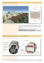
RIEGL VQ-1560 II Scan Pattern Each channel delivers straight parallel scan lines. The scan lines of the two channels are tilted against each other by 28 degrees providing an optimum distribution of the measurements on the ground invariant to changes in terrain height. Tilt Angle of Scan Lines Forward/Backward Scan Angle in Non-Nadir Direction RIEGL VQ-1560 II Elements of Function and Operation mounting flange aperture of primary camera (RGB) aperture of laser channel #2 aperture of laser channel #1 aperture of secondary camera connectors for power supply and data interface desiccant cartridges...
Open the catalog to page 2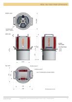
RIEGL VQ-1560 II Main Dimensions Data Sheet Copyright RIEGL Laser Measurement Systems GmbH © 2021– All rights reserved.
Open the catalog to page 3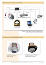
RIEGL VQ-1560 II System Components A minimum number of system components and external cabling is required for an easy and quick installation in aircrafts. RIEGL VQ-1560 II Installation Examples RIEGL VQ-1560 II installed in the nose pod of fixed-wing aircraft DA42 MPP RIEGL VQ-1560 II installed on GSM-4000 gyro-stabilized platform to be used in a helicopter or fixed-wing aircraft Copyright RIEGL Laser Measurement Systems GmbH © 2021– All rights reserved.
Open the catalog to page 4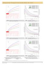
Measurement Range & Point Density RIEGL VQ-1560 II Laser PRR = 2x150kHz, laser power level 100% 20100 Typical ENOHD cliffs, sand, masonry terra cotta deciduous trees coniferous trees dry snow white plaster work, limestone Target Reflectance [%] Operating Flight Altitude [ft] visibility 40 km visibility 23 km visibility 15 km Operating Flight Altitude [m] Example: VQ-1560 II at 2 x 150,000 pulses/sec, laser power level 100% Altitude 14,900 ft AGL, Speed 150 kn Laser PRR = 2x250kHz, laser power level 100% Point Density ~ 1.12 pts/m² Area Acquisition Rate ~ 857 km²/h Point Density ~ 4.12 pts/m²...
Open the catalog to page 5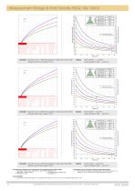
Measurement Range & Point Density RIEGL VQ-1560 II Laser PRR = 2x1000kHz, laser power level 100% 10200 terra cotta cliffs, sand, masonry deciduous trees Typical ENOHD dry snow white plaster work, limestone coniferous trees Target Reflectance [%] Operating Flight Altitude [ft] 3110 visibility 40 km visibility 23 km visibility 15 km Operating Flight Altitude [m] Example: VQ-1560 II at 2 x 1,000,000 pulses/sec, laser power level 100% Altitude 4,000 ft AGL, Speed 170 kn Point Density ~ 11.1 pts/m² Area Acquisition Rate ~ 344 km²/h Point Density ~ 45 pts/m² Area Acquisition Rate ~ 169 km²/h Point...
Open the catalog to page 6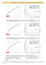
Measurement Range & Point Density RIEGL VQ-1560 II Laser PRR = 2x2000kHz, laser power level 25% 1310 491 dry snow white plaster work, limestone cliffs, sand, masonry terra cotta Typical ENOHD deciduous trees coniferous trees Target Reflectance [%] Operating Flight Altitude [ft] visibility 40 km visibility 23 km visibility 15 km Operating Flight Altitude [m] Example: VQ-1560 II at 2 x 2,000,000 pulses/sec, laser power level 25% Altitude 3,400 ft AGL, Speed 120 kn Point Density ~ 37 pts/m² Area Acquisition Rate ~ 207 km²/h Point Density ~ 61 pts/m² Area Acquisition Rate ~ 127 km²/h Point Density...
Open the catalog to page 7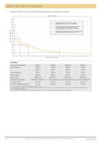
The RIEGL VQ-1560 II Dual Channel Airborne Mapping System offers highest productivity. 8 Copyright RIEGL Laser Measurement Systems GmbH © 2021- All rights reserved. Data Sheet
Open the catalog to page 8All RIEGL LASER MEASUREMENT SYSTEMS GMBH catalogs and technical brochures
 RIEGL VQX-1 Wing Pod
4 Pages
 RIEGL VQ-780 II-S
8 Pages
 RiUNITE
4 Pages
 RIEGL VUX-120
8 Pages
 RIEGL VUX-240
6 Pages
 RIEGL miniVUX-SYS
4 Pages
 RIEGL miniVUX-1LR
4 Pages
 RIEGL miniVUX-3UAV
6 Pages
 RIEGL miniVUX-2UAV
4 Pages
 RIEGL miniVUX-1UAV
4 Pages
 RIEGL VUX-1UAV-22
6 Pages
 RiCOPTER with VUX-SYS
4 Pages
 RIEGL UAV Sensors & Systems
2 Pages
 RIEGL VQ-840-G
6 Pages
 RIEGL VQ-880-G II
6 Pages
 RIEGL VQ-880-GH
6 Pages
 PH-VUX
2 Pages
 RIEGL VPX-1
2 Pages
 RIEGL VP-1
2 Pages
 RIEGL VUX-SYS
4 Pages
 RIEGL VUX-1LR-22
6 Pages
 RIEGL VQ-1560 II-S
10 Pages
 RIEGL VQ-780 II
8 Pages
 RIEGL LD05e-A30-PH67
5 Pages
 RiPROCESS
4 Pages
 RDBLib
2 Pages
 RiCOPTER-M
2 Pages
 RIEGL DR1560i
2 Pages
 RiVLib
4 Pages
 RiCOPTER
2 Pages
 RiHYDRO
2 Pages
 RiACQUIRE
4 Pages
 RIEGL miniVUX-1DL
4 Pages
 LD05-A20 and LD05-A40
7 Pages
 LD05-A80
5 Pages
 RIEGL VQ-580 II
6 Pages
 RIEGL VQ-480 II
6 Pages
 RIEGL VQ-1560i-DW
10 Pages
 LD05e-A10
4 Pages
 LD05e-HT
4 Pages
 LD05-HTGF
13 Pages
 LD05-A10GF
10 Pages
 RiWaveLIB
2 Pages
 BathyCopter
4 Pages


- Aeronautical software
- Process software
- Maintenance software
- 3D software
- Cloud-based software
- Navigation software
- Test software
- Measurement software
- Drone software
- Laser scanner
- Data acquisition software
- Aeronautic laser scanner
- Non-contact laser scanner
- Measurement laser scanner
- Airborne laser scanner
- 3D laser scanner
- LIDAR software
- Laser scanner software
- Drone laser scanner