- Catalogs
- RIEGL LASER MEASUREMENT SYSTEMS GMBH
- RIEGL VQ-1560 II-S
- Company
- Products
- Catalogs
- News & Trends
- Exhibitions
RIEGL VQ-1560 II-S

RIEGL VQ-1560 II-S
- Operational altitudes: Up to 1600m AGL at 4MHz, up to 4000m AGL at 540kHz.
- Laser pulse repetition rates adjustable in 12kHz steps.
- Data acquisition: Up to 2.66 million measurements per second.
- Integrated high-performance IMU/GNSS and optional 150 MP RGB camera.
- Prepared for secondary camera integration (thermal or NIR).
- Unique cross-fire scan pattern.
- Multiple-Time-Around (MTA) processing for up to 45 pulses.
- Atmospheric clutter suppression and online waveform processing.
- Optimized housing for easy aircraft integration.
- Ultra-wide area and high-altitude mapping.
- High point density mapping.
- Mapping complex environments like urban areas, glaciers, and riverbanks.
- Agriculture, forestry, and corridor mapping.
- Point density and area acquisition rates vary with altitude, speed, and laser power.
- Point densities range from 1.11 to 60.72 pts/m²; area acquisition rates from 126 to 931 km²/h.
- Minimum range: 100m with 20mm accuracy and precision.
- Laser pulse repetition rate: 2 x 270kHz to 2 x 2000kHz.
- Effective measurement rate: Up to 2 x 1.33 MHz at a 60° scan angle.
- Laser wavelength: Near-infrared spectrum.
- Parallel and crossed scan lines with a tilt angle of ±14°.
- Scan angle range: 60° per channel, effective FOV of 58°.
- Total scan rate: 40 to 600 lines per second.
- Maximum measuring range: Up to 7100 m for high reflectivity targets.
- Maximum flight altitude: Up to 19,000 ft for high reflectivity targets.
- Safety: NOHD and ENOHD provided.
- Detection: Up to 14 targets per laser pulse.
- Power supply: 20-32 V DC, typical consumption 370 W.
- Protection class: IP54, operational altitude up to 18,500 ft.
- Temperature range: -5°C to +35°C (operation), -10°C to +50°C (storage).
- Supports various cameras, including a 150 MP RGB camera and secondary thermal or NIR camera.
- Data storage via iX-Controller, interfaces through USB 3.0.
- Laser classified as Class 3B according to IEC60825-1:2014, compliant with US regulations.
Catalog excerpts

RIEGL team high laser pulse repetition rate up to 4 MHz up to 2.66 million measurements per second on the ground offers highly efficient data acquisition at a wide range of point densities two waveform processing LiDAR channels offering excellent multiple target detection capability enables Multiple-Time-Around (MTA) processing of up to 45 pulses simultaneously in the air excellent suppression of atmospheric clutter online waveform processing as well as smart and full waveform recording integrated inertial measurement unit and GNSS receiver integrated, easily accessible medium format camera prepared for integration of a secondary camera high-speed fiber data interface to RIEGL data recorder housing shape and mounting flange optimized for interfacing with typical hatches and stabilized platforms detachable handgrips for facilitated handling ^ The new VQ-1560II-S follows the successful concept of RIEGL’s proven dual channel laser scanner series. With increased laser power the operational altitudes are extended up to 1600m AGL at a pulse repetition rate of 4MHz, or up to 4000m AGL at a pulse repetition rate of 540kHz (all values given for 20% target reflectance). These improved maximum ranges allow an increase of the system’s productivity by about 25% for a very attractive point density range. Laser pulse repetition rates can be fine-tuned in 12kHz steps, enabling subtle optimization of acquisition parameters in order to meet specific project requirements. Its unique "cross-fire" scan pattern and its wide operational range make the instrument the most versatile airborne laser scanner on the market today. It is perfectly suited for any kind of application - from ultra-dense corridor mapping from low altitudes, over high resolution city mapping with minimum shadowing effects in narrow street canyons, to large-scale wide area mapping at utmost efficiency of up to 1130km2 per hour at a density of 4 points per square meter. The system is equipped with a seamlessly integrated high performance IMU/GNSS unit and e.g. an optional 150 megapixel RGB camera integrated in the primary camera bay. Optionally, a second camera, e.g. a thermal camera or a 150 megapixels near-infrared camera, can be integrated on request. The design of the compact housing features a mounting flange for interfacing with typical hatches or gyro-stabilized leveling mounts. Applications: • Ultra Wide Area / High Altitude Mapping • Ultra-High Point Density Mapping • Mapping of Complex Urban Environments • Glacier & Snowfleld Mapping • City Modeling • Mapping of Lakesldes & River Banks • Agriculture & Forestry • Corridor Mapping visit our website www, riegl.com RIEGL LASER MEASUREMENT SYSTEMS Preliminary Data Sheet Airborne Laser Scanning
Open the catalog to page 1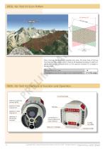
RIEGL VQ-1560 II-S Scan Pattern Each channel delivers straight parallel scan lines. The scan lines of the two channels are tilted against each other by 28 degrees providing an optimum distribution of the measurements on the ground invariant to changes in terrain height. ± 14° Forward/Backward Scan Angle in Non-Nadir Direction Tilt Angle of Scan Lines RIEGL VQ-1560 II-S Elements of Function and Operation mounting flange aperture of primary camera (RGB) aperture of laser channel #2 aperture of laser channel #1 aperture of secondary camera connectors for power supply and data interface desiccant...
Open the catalog to page 2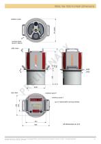
RIEGL VQ-1560 II-S Main Dimensions Preliminary Data Sheet Copyright RIEGL Laser Measurement Systems GmbH © 2021– All rights reserved.
Open the catalog to page 3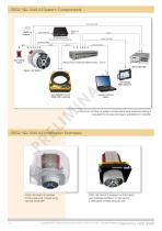
high speed data GNSS antenna camera data recorder Phase One iX Controller (optional) RIEGL Power pilot display flight guidance gyro-stabilized mount GSM-4000 (optional) operator working station A minimum number of system components and external cabling is required for an easy and quick installation in aircrafts.RIEGL VQ-1560 II-S Installation Examples RIEGL VQ-1560 II-S installed in the nose pod of fixed-wing aircraft DA42 MPP RIEGL VQ-1560 II-S installed on GSM-4000 gyro-stabilized platform to be used in a helicopter or fixed-wing aircraft Copyright RIEGL Laser Measurement Systems GmbH © 2021-...
Open the catalog to page 4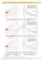
Measurement Range & Point Density RIEGL VQ-1560 II-S Laser PRR = 2x270kHz, laser power level 100% 21500 Typical ENOHD dry snow white plaster work, limestone cliffs, sand, masonry terra cotta deciduous trees coniferous trees Target Reflectance [%] Operating Flight Altitude [ft] 6550 visibility 40 km visibility 23 km visibility 15 km Operating Flight Altitude [m] Example: VQ-1560 II-S at 2 x 270,000 pulses/sec, laser power level 100% Altitude 11,500 ft AGL, Speed 160 kn deciduous trees cliffs, sand, masonry coniferous trees terra cotta Typical ENOHD dry snow white plaster work, limestone Operating...
Open the catalog to page 5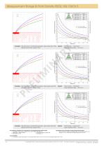
Measurement Range & Point Density RIEGL VQ-1560 II-S Laser PRR = 2x2000kHz, laser power level 100% 10200 Typical ENOHD cliffs, sand, masonry terra cotta deciduous trees coniferous trees dry snow white plaster work, limestone Target Reflectance [%] Operating Flight Altitude [ft] 3110 visibility 40 km visibility 23 km visibility 15 km Operating Flight Altitude [m] Laser PRR = 2x2000kHz, laser power level 50% 6980 dry snow white plaster work, limestone terra cotta cliffs, sand, masonry deciduous trees Typical ENOHD coniferous trees Point Density ~ 16.23 pts/m² Area Acquisition Rate ~ 473 km²/h Operating...
Open the catalog to page 6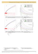
Measurement Range & Point Density RIEGL VQ-1560 II-S Laser PRR = 2x2000kHz, laser power level 12% 4030 dry snow white plaster work, limestone cliffs, sand, masonry terra cotta Typical ENOHD deciduous trees coniferous trees Target Reflectance [%] Operating Flight Altitude [ft] visibility 40 km visibility 23 km visibility 15 km Operating Flight Altitude [m] Laser PRR = 2x2000kHz, laser power level 6% 819 deciduous trees cliffs, sand, masonry coniferous trees terra cotta Typical ENOHD dry snow white plaster work, limestone Point Density ~ 52.8 pts/m² Area Acquisition Rate ~ 145 km²/h Operating Flight...
Open the catalog to page 7All RIEGL LASER MEASUREMENT SYSTEMS GMBH catalogs and technical brochures
 RIEGL VQX-1 Wing Pod
4 Pages
 RIEGL VQ-780 II-S
8 Pages
 RiUNITE
4 Pages
 RIEGL VUX-120
8 Pages
 RIEGL VUX-240
6 Pages
 RIEGL miniVUX-SYS
4 Pages
 RIEGL miniVUX-1LR
4 Pages
 RIEGL miniVUX-3UAV
6 Pages
 RIEGL miniVUX-2UAV
4 Pages
 RIEGL miniVUX-1UAV
4 Pages
 RIEGL VUX-1UAV-22
6 Pages
 RiCOPTER with VUX-SYS
4 Pages
 RIEGL UAV Sensors & Systems
2 Pages
 RIEGL VQ-840-G
6 Pages
 RIEGL VQ-880-G II
6 Pages
 RIEGL VQ-880-GH
6 Pages
 PH-VUX
2 Pages
 RIEGL VPX-1
2 Pages
 RIEGL VP-1
2 Pages
 RIEGL VUX-SYS
4 Pages
 RIEGL VUX-1LR-22
6 Pages
 RIEGL VQ-1560 II
10 Pages
 RIEGL VQ-780 II
8 Pages
 RIEGL LD05e-A30-PH67
5 Pages
 RiPROCESS
4 Pages
 RDBLib
2 Pages
 RiCOPTER-M
2 Pages
 RIEGL DR1560i
2 Pages
 RiVLib
4 Pages
 RiCOPTER
2 Pages
 RiHYDRO
2 Pages
 RiACQUIRE
4 Pages
 RIEGL miniVUX-1DL
4 Pages
 LD05-A20 and LD05-A40
7 Pages
 LD05-A80
5 Pages
 RIEGL VQ-580 II
6 Pages
 RIEGL VQ-480 II
6 Pages
 RIEGL VQ-1560i-DW
10 Pages
 LD05e-A10
4 Pages
 LD05e-HT
4 Pages
 LD05-HTGF
13 Pages
 LD05-A10GF
10 Pages
 RiWaveLIB
2 Pages
 BathyCopter
4 Pages


- Aeronautical software
- Process software
- Maintenance software
- 3D software
- Cloud-based software
- Navigation software
- Test software
- Measurement software
- Drone software
- Data acquisition software
- Aeronautic laser scanner
- Non-contact laser scanner
- Measurement laser scanner
- 3D laser scanner
- LIDAR software
- Laser scanner software
- Drone laser scanner