- Catalogs
- RIEGL LASER MEASUREMENT SYSTEMS GMBH
- LIS ALS Classification Plugin
- Company
- Products
- Catalogs
- News & Trends
- Exhibitions
LIS ALS Classification Plugin

LIS ALS Classification Plugin
This document describes the LIS ALS Classification Plugin, which is designed to classify point cloud data into ground, building, and vegetation points. It integrates seamlessly with the RiPROCESS data processing software, eliminating the need for data export and tiling for third-party classification. The plugin supports multi-threaded processing for efficient data analysis.
The plugin can process the entire project data, specific flight strips, or user-defined regions of interest. It performs on-the-fly data tiling with overlap, and the classification results are written back to the data records without overlap. Classification identifiers adhere to the ASPRS LAS standard.
The ground classifier uses progressive TIN densification to distinguish between ground and non-ground points. It offers three default settings for different terrain types (flat, sloped, steep) and allows for parameter fine-tuning in advanced settings. Additionally, it calculates the height above ground for each point, storing it as an attribute for further analysis.
This classifier separates non-ground points into building, vegetation, and undefined classes. Building detection is achieved through point cloud segmentation and local point neighborhood analysis. Filters are available to remove vegetation from building roofs and clean facades. Vegetation points are filtered by local density and categorized into low, medium, and high vegetation.
The document lists the ASPRS LAS class codes used: 1 for unclassified, 2 for ground, 3 for low vegetation, 4 for medium vegetation, 5 for high vegetation, and 6 for buildings.
The document is copyrighted by RIEGL Laser Measurement Systems GmbH and requires written consent for use beyond personal purposes. While compiled with care, errors may exist, and alterations might be necessary.
Catalog excerpts

LIS ALS Classification Plugin RiPROCESS – Airborne LiDAR Point Cloud Classification This plug-in facilitates the classification of point cloud data into ground, building and vegetation points. It is fully integrated into the RiPROCESS data processing software package and works directly on the project’s RDB2 point cloud data. Data export and tiling for classification in thirdparty software are not required. Data analysis is further streamlined by multi-threaded processing.
Open the catalog to page 1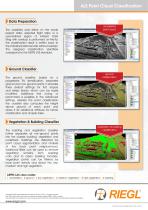
ALS Point Cloud Classification Data Preparation The classifiers work either on the whole project data, selected flight strips or a user-defined region of interest. Data tiling with overlap is performed on-the-fly, the classification result is written back to the individual data records without overlap. The assigned classification identifiers correspond to the ASPRS LAS standard. unclassified point cloud Ground Classifier The ground classifier, based on a progressive TIN densification, separates ground and non-ground points. It provides three default settings for flat, sloped and steep terrain,...
Open the catalog to page 2All RIEGL LASER MEASUREMENT SYSTEMS GMBH catalogs and technical brochures
 RIEGL VQX-1 Wing Pod
4 Pages
 RIEGL VQ-780 II-S
8 Pages
 RiUNITE
4 Pages
 RIEGL VUX-120
8 Pages
 RIEGL VUX-240
6 Pages
 RIEGL miniVUX-SYS
4 Pages
 RIEGL miniVUX-1LR
4 Pages
 RIEGL miniVUX-3UAV
6 Pages
 RIEGL miniVUX-2UAV
4 Pages
 RIEGL miniVUX-1UAV
4 Pages
 RIEGL VUX-1UAV-22
6 Pages
 RiCOPTER with VUX-SYS
4 Pages
 RIEGL UAV Sensors & Systems
2 Pages
 RIEGL VQ-840-G
6 Pages
 RIEGL VQ-880-G II
6 Pages
 RIEGL VQ-880-GH
6 Pages
 PH-VUX
2 Pages
 RIEGL VPX-1
2 Pages
 RIEGL VP-1
2 Pages
 RIEGL VUX-SYS
4 Pages
 RIEGL VUX-1LR-22
6 Pages
 RIEGL VQ-1560 II-S
10 Pages
 RIEGL VQ-1560 II
10 Pages
 RIEGL VQ-780 II
8 Pages
 RIEGL LD05e-A30-PH67
5 Pages
 RiPROCESS
4 Pages
 RDBLib
2 Pages
 RiCOPTER-M
2 Pages
 RIEGL DR1560i
2 Pages
 RiVLib
4 Pages
 RiCOPTER
2 Pages
 RiHYDRO
2 Pages
 RiACQUIRE
4 Pages
 RIEGL miniVUX-1DL
4 Pages
 LD05-A20 and LD05-A40
7 Pages
 LD05-A80
5 Pages
 RIEGL VQ-580 II
6 Pages
 RIEGL VQ-480 II
6 Pages
 RIEGL VQ-1560i-DW
10 Pages
 LD05e-A10
4 Pages
 LD05e-HT
4 Pages
 LD05-HTGF
13 Pages
 LD05-A10GF
10 Pages
 RiWaveLIB
2 Pages
 BathyCopter
4 Pages


- Aeronautical software
- Process software
- Maintenance software
- 3D software
- Cloud-based software
- Navigation software
- Test software
- Measurement software
- Drone software
- Laser scanner
- Data acquisition software
- Aeronautic laser scanner
- Non-contact laser scanner
- Measurement laser scanner
- Airborne laser scanner
- 3D laser scanner
- LIDAR software
- Pod
- Laser scanner software
- Drone laser scanner