- Catalogs
- RIEGL LASER MEASUREMENT SYSTEMS GMBH
- BathyCopter
- Company
- Products
- Catalogs
- News & Trends
- Exhibitions
BathyCopter

BathyCopter
- RIEGL BDF-1: A compact bathymetric depth finder with a tilt compensator, IMU/GNSS unit, control unit, and optional digital cameras.
- Optional miniVUX-1UAV LiDAR Sensor: Enhances data collection capabilities.
- Floating Support: Allows safe water landings and take-offs.
- Profiling shorelines and inland water bodies such as rivers, lakes, and channels.
- Repeated surveys of water reservoirs and canal surveying.
- Landscaping and planning for hydraulic engineering work.
- Laser Class: IEC 60825-1:2014 Class 2M.
- Operating Flight Altitude: 10 - 40 m AWSL.
- MTOM: 25 kg.
- Flight Endurance: Up to 30 minutes.
- Measurement Direction: Downward-looking, 15° off nadir.
- Active Pitch Compensation: 24° range.
- Achievable Secchi Depth: Varies with measurement rate, up to 1.5 Secchi depth.
- Integrated Camera: Sony Alpha 6000.
- IMU/GNSS Unit: Applanix APX-15 UAV.
- Operation Temperature: +10°C to +40°C.
Catalog excerpts

The BathyCopter is a UAV-based LiDAR surveying system for bathymetric applications, ideally suited for generating profiles of shorelines and inland waterbodies. The robust and reliable platform design of RIEGL‘s remotely piloted RiCOPTER now integrates the RIEGL BDF-1, a compact and lightweight bathymetric depth finder comprising a tilt compensator, an IMU/GNSS unit with antenna, a control unit, and up to two external digital cameras. The RIEGL BDF-1 can optionally be supplemented with a miniVUX-1UAV LiDAR sensor. UAV-Based Surveying System for Hydrographic Applications Typical Applications • Generation of profiles of shorelines and inland water bodies (rivers, lakes, channels) • Repeated survey of water reservoirs • Canal surveying • Landscaping • Surveys for planning and hydraulic engineering work Scan this QR code to watch the BathyCopter video. www.riegl.com www.r
Open the catalog to page 1
BathyCopter Measuring Principle tilt compensation Flight Direction constant angle flight path profile view The drawings above illustrate the measurement principle of the BDF-1 when operated from a UAV: The UAV performs a meanderlike flight path over an inland water body (river, channel, or lake) while the BDF-1 is measuring downward. In case the optional tilt compensator is used, the measuring angle is user-defined and stabilized. Profiles of the water surface (blue dots), ground (green dots) as well as the surrounding landscape (red dots) are generated this way. The multi-target capability of...
Open the catalog to page 2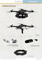
BathyCopter General Setup RIEGL miniVUX-1UAV LiDAR sensor equipped with APX-15 UAV or APX-20 UAV and optional cameras BDF-1 bathymetric depth finder with Sony alpha 6000 camera floating support Copyright RiCOPTER UAV GmbH © 2018 – All rights reserved.
Open the catalog to page 3
at a glance BathyCopter Key Features • UAV-based surveying system for hydrographic applications • ideally suited for generating profiles of shorelines and inland waterbodies • fully integrated solution, comprising RIEGL Bathymetric Depth Finder BDF-1 providing up to 1.5 Secchi depth measuring range • floating support for safe water landing and take-off from water bodies • excellent performance even at adverse conditions based on predetection averaging • highly accurate, reliable and informative bathymetric data resulting from RIEGL‘s proprietary hydrographic waveform processing • modular setup1):...
Open the catalog to page 4All RIEGL LASER MEASUREMENT SYSTEMS GMBH catalogs and technical brochures
 RIEGL VQX-1 Wing Pod
4 Pages
 RIEGL VQ-780 II-S
8 Pages
 RiUNITE
4 Pages
 RIEGL VUX-120
8 Pages
 RIEGL VUX-240
6 Pages
 RIEGL miniVUX-SYS
4 Pages
 RIEGL miniVUX-1LR
4 Pages
 RIEGL miniVUX-3UAV
6 Pages
 RIEGL miniVUX-2UAV
4 Pages
 RIEGL miniVUX-1UAV
4 Pages
 RIEGL VUX-1UAV-22
6 Pages
 RiCOPTER with VUX-SYS
4 Pages
 RIEGL UAV Sensors & Systems
2 Pages
 RIEGL VQ-840-G
6 Pages
 RIEGL VQ-880-G II
6 Pages
 RIEGL VQ-880-GH
6 Pages
 PH-VUX
2 Pages
 RIEGL VPX-1
2 Pages
 RIEGL VP-1
2 Pages
 RIEGL VUX-SYS
4 Pages
 RIEGL VUX-1LR-22
6 Pages
 RIEGL VQ-1560 II-S
10 Pages
 RIEGL VQ-1560 II
10 Pages
 RIEGL VQ-780 II
8 Pages
 RIEGL LD05e-A30-PH67
5 Pages
 RiPROCESS
4 Pages
 RDBLib
2 Pages
 RiCOPTER-M
2 Pages
 RIEGL DR1560i
2 Pages
 RiVLib
4 Pages
 RiCOPTER
2 Pages
 RiHYDRO
2 Pages
 RiACQUIRE
4 Pages
 RIEGL miniVUX-1DL
4 Pages
 LD05-A20 and LD05-A40
7 Pages
 LD05-A80
5 Pages
 RIEGL VQ-580 II
6 Pages
 RIEGL VQ-480 II
6 Pages
 RIEGL VQ-1560i-DW
10 Pages
 LD05e-A10
4 Pages
 LD05e-HT
4 Pages
 LD05-HTGF
13 Pages
 LD05-A10GF
10 Pages
 RiWaveLIB
2 Pages


- Aeronautical software
- Process software
- Maintenance software
- 3D software
- Cloud-based software
- Navigation software
- Test software
- Measurement software
- Drone software
- Laser scanner
- Data acquisition software
- Aeronautic laser scanner
- Non-contact laser scanner
- Measurement laser scanner
- Airborne laser scanner
- 3D laser scanner
- LIDAR software
- Pod
- Laser scanner software
- Drone laser scanner