
- Catalogs
- RAYMETRICS SA
- Raymetrics-Aviation Presentation


Raymetrics-Aviation Presentation

Raymetrics-Aviation Presentation
LIDAR technology, though new to aviation, is based on standard techniques used in ceilometers. A new ISO standard has been established for calculating various visual ranges, including Runway Visual Range (RVR) and Slant Visual Range (SVR). Raymetrics 3D scanning LIDARs offer innovative solutions for aviation challenges.
Main Features of Raymetrics LIDARs:
- Eye-safe and certified with no visible range disturbance.
- No electromagnetic interference and fully customizable.
- Programmable for different operational modes and remotely controlled.
Applications and Benefits:
- Visibility Measurement: Provides SVR, offering a more accurate reflection of pilot visibility compared to RVR.
- Cloud Base Measurement: 3D scanning LIDARs provide a comprehensive view of cloud bases, potentially replacing multiple ceilometers.
- Fog Detection: Detects incoming fog banks and predicts arrival times, aiding in early warning scenarios.
- Special Cases: Useful for detecting volcanic ash, natural dust, and fire smoke.
Challenges of Haze:
Haze causes visibility reduction and health effects. Visibility is affected by light absorption and scattering, primarily by particles.
International Standards and Data Accuracy:
An ISO standard (ISO 28902-1:2012) for ground-based remote sensing of visual range with LIDAR was created in collaboration with WMO and ICAO. Raymetrics LIDARs conform to these standards, ensuring high data accuracy.
Operational Installations:
- First operational systems installed at Changi Airport, Singapore, and Heydar Aliyev International Airport, Baku, Azerbaijan.
Case Study:
Volcanic ash from the Eyjafjallajokull eruption was detected using Raymetrics LIDAR, demonstrating its capability in tracking atmospheric phenomena.
Catalog excerpts

Advanced Backscatter LIDARS (Aviation)
Open the catalog to page 1
Big Projects New Challenges require New solution – Innovation Runway Visual Range (RVR) Raymetrics 3D scanning LIDARs can function as multi-purpose aviation tools 1. Visibility Provides Slant Visual Range (SVR) – more accurate reflection of pilot’s visibility compared to Runway Visual Range (RVR) 2. Scanning Ceilometer Provides 3D cloud base (total ceiling) instead of cloud height at a single point like a ceilometer (which is a basic LIDAR) Slant Visual Range (SVR) 3. Fog incoming bangs Detection for Better Forecasting Remotely detects incoming fog banks and indicates time of arrival – function...
Open the catalog to page 2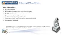
Runway Visual Range (RVR) Main Characteristics: • EYE-Safe (certified) No eye disturbance (No-visible range of wavelengths) Fully customized for specific requirements Fully programmable for different actions (operational modes) Fully remotely controlled Slant Visual Range (SVR) Note: LIDARs are “new” for aviation but the techniques are actually standard (ceilometers use LIDAR technique). There is a new ISO for calculating MOR, VOR, SOR, SVR,
Open the catalog to page 3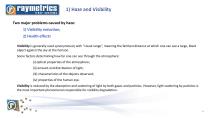
Two major problems caused by haze: 1) Visibility reduction; 2) Health effects Visibility is generally used synonymously with “visual range”, meaning the farthest distance at which one can see a large, black object against the sky at the horizon. Some factors determining how far one can see through the atmosphere: (i) optical properties of the atmosphere; (ii) amount and distribution of light; (iii) characteristics of the objects observed; (iv) properties of the human eye. Visibility is reduced by the absorption and scattering of light by both gases and particles. However, light scattering by...
Open the catalog to page 4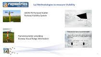
la) Methodologies to measure Visibility AGVIS FSI Forward Scatter Runway Visibility System Transmissometer providing Runway Visual Range information
Open the catalog to page 5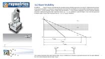
lc) Slant Visibility EXAMPLE Figure 3 shows schematically the situation during a landing approach at an airport. A light transmissometer at the ground (baseline xl) measures Fmor [Equation (5)] under the assumption of a horizontally homogeneous extinction coefficient m in this example, Fmor is larger than the baseline xl. Fsor requires integration over the vertically stratified extinction coefficient [Equation (8)]. Under low stratus (cq > m, <23) conditions, a pilot at height h, thus sees the ground at a steeper angle (Fsori) than in ground fog (m > 02, <23; FsoR2) conditions. The scheme illustrates...
Open the catalog to page 6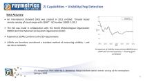
Data Accuracy An International Standard (ISO) was created in 2012 entitled: “Ground based remote sensing of visual range with LIDAR” - ISO number 28902-1:2012 The ISO was made in collaboration with the World Meteorological Organization (WMO) and International Civil Aviation Organization (ICAO) Raymetrics LIDARs conform to the ISO requirements LIDARs are therefore considered a standard method of measuring visibility – and can do so remotely Comparison of visibility measurement (MOR) from a LIDAR and a transmissometer – showing good correlation (*). Comparison Plots taken by C. Weitkamp,...
Open the catalog to page 7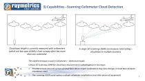
Runway Visual Range (RVR) Slant Visual Range (SVR) Cloud base height is currently measured with ceilometers (which are low-spec LIDARs). Each runway often has more than one ceilometer. A single 3D scanning LIDAR can measure total ceiling – cloud base in multiple locations The LIDAR technique is used in Ceilometers – identical principle Using a 3D Scanning LIDAR for cloud base measurement is advantageous in two ways: 1. Provides a more accurate picture of cloud base above airport (ceilometers may miss changes in cloud base between installation sites) 2. One scanning LIDAR could replace multiple...
Open the catalog to page 8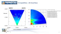
raymetrics lidar systems 4) Capabilities - 3D Cloud Base 3.0km
Open the catalog to page 9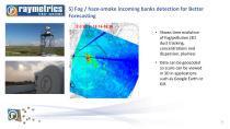
5) Fog / haze-smoke incoming banks detection for Better Forecasting Shows time evolution of fog/pollution (3D dust tracking, concentrations and dispersion, plumes) Data can be geocoded so scans can be viewed in 3D in applications such as Google Earth or GIS
Open the catalog to page 10
5) Fog incoming banks Detection for Better Forecasting • 13:40:50 - Fog bang detected at 7150 meters • 13:45:50 - Fog bang detected at • 6450 meters In 5 minutes fog approached lidar more than 500 meters
Open the catalog to page 11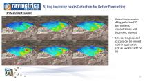
5) Fog incoming banks Detection for Better Forecasting Shows time evolution of fog/pollution (3D dust tracking, concentrations and dispersion, plumes) Data can be geocoded so scans can be viewed in 3D in applications such as Google Earth or GIS
Open the catalog to page 12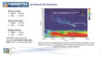
355nm Co-Polar Night: > 14 kmDay: > 12 km ATHENS, NTUA, LIDAR, RCS@1064nm, 21 - 22 APRIL 2010 15:35UTC - 8:58UTC, RESOLUTION 15m - 90sec 355nm Cross-Polar Night: > 12 kmDay: > 11 km VOLCANIC ASH Nitrogen Raman Night: > 12 kmDay: > 3 km 45004000350030002500200015001000- IMPORTANT: Values above are achievable with Signal to Noise Ratio (SNR) > 10 (i.e. very high quality data) Volcanic ash from the Eyjafjallajokull eruption in 2010 detected at heights of 10 km down to 5 km over a 12 hour period with a LIDAR built by Raymetrics for National Technical University of Athens (NTUA)
Open the catalog to page 13
lidar systems First operational system installed for the National Environment Agency (NEA) FOR CHANGI AIRPORT in Singapore ’SELE.WR AIRPORT
Open the catalog to page 14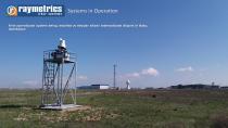
First operational system being installed at Heydar Aliyev International Airport in Baku, Azerbaijan
Open the catalog to page 15All RAYMETRICS SA catalogs and technical brochures
 3D Aerosol LIDAR
4 Pages
 Aerosol LIDAR
3 Pages
 customized LIDARs
5 Pages