SCOUT-8

SCOUT-8
The Scout-8 is the latest model in the Scout Series, designed for cost-effective LiDAR scanning up to 75 meters above ground level (AGL) with up to three returns. It offers customization options including photogrammetry, hyperspectral, and thermal imaging.
Features
- Increased range at a competitive price.
- Mountable on drones, ground vehicles, or backpacks.
- Modular upgrades available, including dual LiDAR sensors and various camera types.
Navigation System
- Supports GPS, GLONASS, BEIDOU, and GALILEO constellations.
- Offers kinematic and single-antenna alignment.
- Operates in real-time with optional postprocessing.
- Position accuracy: 1 cm + 1 ppm RMS horizontal.
- Attitude heading RMS error: 0.019° with IMU options.
Specifications
- Absolute accuracy: 100 mm RMSE at 50m range.
- Weight: 1.93 kg (4.25 lbs).
- Dimensions: 18.8 x 11.6 x 11.6 cm.
- Laser range: 200m at 80% reflectivity.
- Scan rate: 420k shots/s, up to 3 returns.
Platform
- Operating voltage: 12 - 28V.
- Power consumption: ~30 W.
- Operating temperature: -20° to +60° C.
Applications
- General mapping, construction site surveying, utilities mapping, agriculture and forestry monitoring, oil and gas surveying, railway track mapping, and open pit mining operations.
LiDAR Sensor
- Laser properties: 905nm Class 1 (eye safe).
- Number of lasers: 8 with a 20° vertical field of view.
- Horizontal field of view: 360°.
- Sensor classification: IP67.
Software Suite
- Phoenix LiDAR Systems offers a complete software suite for mission planning, acquisition, georeferencing, data fusion, and export.
- Includes PLS Spatial Explorer for in-field QA/QC and PLS Spatial Lighthouse for real-time corrections.
- LiDARMill provides cloud-based post-processing, reducing costs and turnaround times.
Camera Accessories
- Options include single RGB, dual RGB, thermal, and hyperspectral cameras.
Operating Conditions
- Assumes ambiguity resolved by multiple-time-around processing and flight planning.
- Target size should be greater than or equal to the laser footprint.
- Average ambient brightness considered.
Catalog excerpts

SCOUT-8 The Scout-8 is the newest addition to the Scout Series, taking cost-effective LiDAR scanning to new heights at up to 75 meters AGL and offering up to 3 returns. Customize your SCOUT-8 with photogrammetry, hyperspectral, thermal imaging, and additional options. FEATURES » Increased range at a competitive price » Mount on a multi-rotor drone, ground vehicle, or backpack » Modular upgrades: Dual LiDAR Sensors; HighRes DSLR; RGB GigE Cam; thermal, hyperspectral cameras; panoramic/spherical cameras & more QUICK SPECS Absolute Accuracy 100 mm RMSE @ 50m Range OVERALL DIMENSIONS PP Attitude Heading RMS Error 0.019° IMU options OPERATING VOLTAGE POWER CONSUMPTION OPERATING TEMPERATURE WEIGHT (including NavBox) Dimensions 18.8 x 11.6 x 11.6 (cm) Laser Range 200m @ 80% Reflectivity LiDAR SENSOR LASER PROPERTIES MAX EFFECTIVE MEASUREMENT RATE Scan Rate 420k shots/s, up to 3 returns HORIZONTAL FIELD OF VIEW SENSOR CLASSIFICATION » Oil & Gas Surveying » Utilities Mapping NAVIGATION SYSTEM CONSTELLATION SUPPORT GPS + GLONASS + BEIDOU + GALILEO SUPPORT ALIGNMENT Kinematic, Single-Antenna » Agriculture & Forestry Monitoring OPERATION MODES Real-time, Postprocessing optional » Construction Site Surveying ACCURACY POSITION PP ATTITUDE HEADING RMS ERROR » Railway Track Mapping » Open Pit Mining Operations
Open the catalog to page 1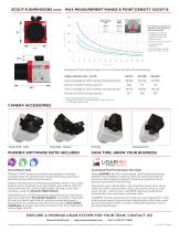
MAX MEASUREMENT RANGE & POINT DENSITY SCOUT-8 250 Flight Altitude AGL Swath Width The following conditions are assumed for the Operating Flight Altitude AGL • ambiguity resolved by multiple-time-around (MTA) processing and flight planning • target size ≥ laser footprint • average ambient brightness • operating flight altitude given at a FOV of +/-45° Example of a 20-Minute Flight @ 5 m/s (3 mins for take-off and landing) Flight Altitude AGL* (m/ft) Area Coverage at 20% Overlap (hectare/acres) Density at 20% Overlap (pts/m) 188.7 Area Coverage at 50% Overlap (hectare/acres) Density at 50% Overlap...
Open the catalog to page 2All Phoenix LiDAR Systems catalogs and technical brochures
 RANGER XL
2 Pages
 RANGER ULTRA
2 Pages
 RANGER-LR LITE
2 Pages
 RANGER-UAV
4 Pages
 RANGER-HA
3 Pages
 RANGER-LR
4 Pages
 SCOUT ULTRA
2 Pages
 SCOUT-32
2 Pages
 SCOUT-16
2 Pages
 RECON-A
2 Pages
 RECON-XT
2 Pages
 miniRanger-3 LITE
2 Pages
 Phoenix UAV LiDAR Systems
20 Pages
- Aeronautical software
- Real-time software
- Process software
- Maintenance software
- 3D software
- Cloud-based software
- Drone software
- Web-based software
- Data acquisition software
- Calculation software
- LIDAR laser
- Drone LIDAR laser
- Mapping LIDAR laser
- Data collection software
- Surveying LIDAR laser
- LIDAR software
- Measurement LIDAR laser
- 3D LIDAR laser
- Viewer software