- Catalogs
- Phoenix LiDAR Systems
- SCOUT-32
SCOUT-32

SCOUT-32
- Best accuracy among SCOUT Series models.
- Optimized for weight and accuracy.
- Mountable on drones, ground vehicles, or backpacks.
- Modular upgrades available, including dual LiDAR sensors and various cameras.
- Dimensions: Sensor - 24.6 x 11.6 x 11.6 cm; Nav Box - 9.8 x 11.6 x 11.6 cm.
- Operating Voltage: 12-28 V.
- Power Consumption: ~50 W.
- Operating Temperature: -10° to +40° C.
- Weight: 2.4 kg including Nav Box.
- Laser Properties: 905 nm Class 1 (eye safe).
- Range: 1.0 m to 100 m with 2 mm resolution.
- Max Measurement Rate: 700,000 measurements per second.
- Field of View: Horizontal - 360°, Vertical - 41.33°.
- Accuracy: Up to ±2 cm.
- Sensor Classification: IP67.
- Constellation Support: GPS, GLONASS, BEIDOU, GALILEO.
- Operation Modes: Real-time, with optional post-processing.
- Accuracy: Position - 1 cm + 1 ppm RMS horizontal.
Catalog excerpts

SCOUT-32 The SCOUT-32 is a robust, mid-range member of the Scout Series. This lightweight system collects survey-grade data with an AGL range up to 65m. An excellent option for building high-density point clouds of smaller scan areas, customize your SCOUT-32 with photogrammetry, hyperspectral, thermal imaging, and additional options. FEATURES » Best accuracy among SCOUT Series models » Engineered to optimize weight & accuracy » ount on a multi-rotor drone, ground vehicle, M or backpack » odular upgrades: Dual LiDAR Sensors; High-Res M DSLR; RGB GigE Cam; thermal, hyperspectral cameras; panoramic/spherical cameras & more QUICK SPECS Absolute Accuracy 35-55 mm RMSE @ 50 m Range OVERALL DIMENSIONS (Sensor) OVERALL DIMENSIONS (Nav Box) PP Attitude Heading RMS Error 0.019 / 0.074 ° IMU options OPERATING VOLTAGE Weight 2.4kg /5.3lbs. Dimensions 24.6 x 11.6 x 11.6 (cm) Laser Range 107 m @ 60% Reflectivity Scan Rate 700 k points/s, up to 2 returns POWER CONSUMPTION OPERATING TEMPERATURE LiDAR SENSOR LASER PROPERTIES MAX EFFECTIVE MEASUREMENT RATE HORIZONTAL FIELD OF VIEW » Utilities Mapping » Railway Track Mapping VERTICAL FIELD OF VIEW SENSOR CLASSIFICATION LASER BEAM FOOTPRINT H x V » Agriculture & Forestry Monitoring » Construction Site Surveying » Open Pit Mining Operations » General Mapping NAVIGATION SYSTEM CONSTELLATION SUPPORT GPS+GLONASS+BEIDOU +GALILEO SUPPORT ALIGNMENT Kinematic, Single-Antenna OPERATION MODES Real-time, Post-processing optional ACCURACY POSITION PP ATTITUDE HEADING RMS ERROR
Open the catalog to page 1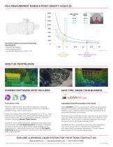
Point Density (points/m MAX MEASUREMENT RANGE & POINT DENSITY SCOUT-32 1600 Swath Width The following conditions are assumed for the Operating Flight Altitude AGL • targetsize ≥ laser footprint • average ambient brightness • operating flight altitude given at a FOV of +/- 90° Speed (m/s) 8 m/s Approx. DJI M600 Scan Speed 25 m/s Approx. Terra Hawk CW - 20 Scan Speed PHOENIX SOFTWARE SUITE INCLUDED SAVE TIME, GROW YOUR BUSINESS Automated Post-Processing in the Cloud Phoenix LiDAR Systems provides a proprietary complete software suite for streamlined, mission planning, acquisition, georeferencing,...
Open the catalog to page 2All Phoenix LiDAR Systems catalogs and technical brochures
 RANGER XL
2 Pages
 RANGER ULTRA
2 Pages
 RANGER-LR LITE
2 Pages
 RANGER-UAV
4 Pages
 RANGER-HA
3 Pages
 RANGER-LR
4 Pages
 SCOUT ULTRA
2 Pages
 SCOUT-16
2 Pages
 SCOUT-8
2 Pages
 RECON-A
2 Pages
 RECON-XT
2 Pages
 miniRanger-3 LITE
2 Pages
 Phoenix UAV LiDAR Systems
20 Pages
- Aeronautical software
- Real-time software
- Process software
- Maintenance software
- 3D software
- Cloud-based software
- Drone software
- Web-based software
- Data acquisition software
- Calculation software
- LIDAR laser
- Drone LIDAR laser
- Mapping LIDAR laser
- Data collection software
- Surveying LIDAR laser
- LIDAR software
- Measurement LIDAR laser
- 3D LIDAR laser
- Viewer software