RECON-A

RECON-A
- Lightest unit in its class.
- Multi-pattern acquisition for high-density data collection, even with low reflectance.
- Dimensions: 19.9 x 9.2 x 12.1 cm
- Weight: 1.2 kg (2.64 lbs)
- Camera FOV: 70°
- Camera Resolution: 24MP
- External Storage: 256GB USB Drive
- Operating Temperature: -20°C to +40°C
- Laser Properties: 905 nm Class 1 (eye safe)
- Distance Random Error: < 2 cm at 20 m (80% Reflective)
- Range Max: 190 m
- Range Accuracy: ±2 cm
- Scan Rate: Up to 720,000 points/s
- Field of View: Non-repetitive (70.4° x 77.2°), Repetitive (70.4° x 4.5°)
- Max Returns Supported: 3
- Beam Divergence: 0.03° x 0.28°
- Constellation Support: GPS, GLONASS, BEIDOU, GALILEO
- Support Alignment: Kinematic, Dual-Antenna (optional)
- Operation Modes: Post-processing only
- Position Accuracy: 0.5 cm (PPK Estimated)
- Attitude Accuracy: <0.01° Pitch & Roll; <0.05° Heading
- Absolute Accuracy: <10 cm x <5 cm at 50 m flight altitude AGL
- Weight: 1.2 kg (2.64 lbs)
- Dimensions: 19.9 x 9.2 x 12.1 cm
- Max Flight Time: 35 Minutes
- General Mapping
- Construction Site Surveying
- Utilities Mapping
- Agriculture & Forestry Monitoring
- Stockpile Volumetrics
- Open Pit Mining Operations
- Non-Repetitive Pattern Scan: Increases vertical FOV to 77.2°, ideal for scanning structures like power line towers.
- Repetitive Line Scan: Adjusts vertical FOV to 4.5°, suitable for jobs requiring high accuracy.
- Flight Altitude AGL: 40 m to 100 m
- Swath Width: 56 m to 140 m
- Point Density: Varies with speed and altitude
- Imagery GSD: 0.98 cm to 2.44 cm
Catalog excerpts

RECON-A The Phoenix RECON-A is the ideal solution for reconnaissance mapping missions such as vegetation encroachment on power lines. This all-in-one payload offers ease of use and efficient data collection all at an affordable price point. The RECON-A maximizes point cloud density by utilizing it’s multi-pattern laser to pick up even the lowest reflective points. The integrated 24 MP high resolution camera has the same FOV as the LiDAR sensor yielding maximum RGB colorization of the point cloud. FEATURES » Lightest unit in its class » Multi-Pattern acquisition allows for high density data even with low reflectance DJI M300 QUICK SPECS Absolute Accuracy (H x V) <10 cm x <5 cm @ 50 m flight altitude AGL OVERALL DIMENSIONS (Sensor) CAMERA RESOLUTION EXTERNAL STORAGE OPERATING TEMPERATURE Multi-Pattern Scanning Repetitive line scan or Non-repetitive scanning pattern Max DJI M300 Flight time 35 Minutes LiDAR SENSOR LASER PROPERTIES DISTANCE RANDOM ERROR UTILITIES MAPPING CONSTRUCTION SITE SURVEYING AGRICULTURE & FORESTRY MONITORING SCAN RATE RANGE ACCURACY 240,000 points/s (first or strongest return) 480,000 points/s (dual return) 720,000 points/s (triple return) Non-repetitve scanning pattern: 70.4° × 77.2° Repetitive line scanning: 70.4° × 4.5° NAVIGATION SYSTEM CONSTELLATION SUPPORT GPS+ GLONASS+ BEIDOU + GALILEO SUPPORT ALIGNMENT Kinematic, Dual-Antenna (optional) STOCKPILE VOLUMETRICS OPERATION MODES Post-processing only POSITION ACCURACY GENERAL MAPPING ATTITUDE ACCURACY <0.01° Pitch & Roll; <0.05° Heading
Open the catalog to page 1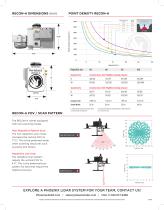
POINT DENSITY RECON-A Flight Altitude AGL Swath Width Covered Area: 20% Flightline Overlap (ha/ac) Covered Area: 50% Flightline Overlap (ha/ac) Swath Width RECON-A FOV / SCAN PATTERN 1) Flight Altitude Above Ground Level (AGL) 2) Assuming 30 min flight time 3) Average Point Density calculated based on 80% reflectivity 4) ± 35° field of view Repetitive Line Scan The repetitive scan pattern adjusts the vertical FOV to 4.5°. This is the preferred scan pattern for jobs that require the highest accuracy. Non-Repetitive Pattern Scan The non-repetitive scan mode increases the vertical FOV to 77.2°. This...
Open the catalog to page 2All Phoenix LiDAR Systems catalogs and technical brochures
 RANGER XL
2 Pages
 RANGER ULTRA
2 Pages
 RANGER-LR LITE
2 Pages
 RANGER-UAV
4 Pages
 RANGER-HA
3 Pages
 RANGER-LR
4 Pages
 SCOUT ULTRA
2 Pages
 SCOUT-32
2 Pages
 SCOUT-16
2 Pages
 SCOUT-8
2 Pages
 RECON-XT
2 Pages
 miniRanger-3 LITE
2 Pages
 Phoenix UAV LiDAR Systems
20 Pages
- Aeronautical software
- Real-time software
- Process software
- Maintenance software
- 3D software
- Cloud-based software
- Drone software
- Web-based software
- Data acquisition software
- Calculation software
- LIDAR laser
- Drone LIDAR laser
- Mapping LIDAR laser
- Data collection software
- Surveying LIDAR laser
- LIDAR software
- Measurement LIDAR laser
- 3D LIDAR laser
- Viewer software