- Catalogs
- Phoenix LiDAR Systems
- RANGER-UAV
RANGER-UAV

RANGER-UAV
- Accuracy: Absolute accuracy of 25-35 mm RMSE at 250m range.
- Weight and Dimensions: Weighs 5.3 kg (11.7 lbs) with dimensions of 30.8 L x 18 W x 12.9 H (cm).
- Laser Range: 920 meters at 60% reflectivity.
- Scan Rate: Up to 500,000 shots per second with up to 7 returns.
- Survey-grade accuracy with a 920m+ laser range.
- IMU and dual-GPS upgrade options for enhanced accuracy.
- Fully autonomous and can be mounted on various platforms including drones, cars, boats, and backpacks.
- Modular upgrade options available for different sensors.
- Supports GPS and GLONASS constellations.
- Offers static, kinematic, and dual-antenna alignment.
- Real-time operation with optional post-processing.
- Rotating mirror scanning mechanism with speeds of 10-200 scans/sec.
- Angular step width between 0.006° and 1.5°.
- Angle measurement resolution of 0.001°.
- Operating voltage between 12 - 28 V with a power consumption of 90 W.
- Operating temperature range from 0° to +40° C.
- Laser properties: 1550 nm Class 1 (eye safe).
- Minimum range of 3 meters.
- Field of view of 360° with an accuracy of 10 mm at 150m.
Catalog excerpts
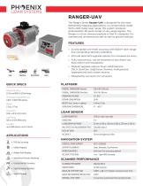
RANGER-UAV The Ranger Series Ranger-UAV is designed for the most demanding mapping applications, no compromises made. With a 920 meter laser range, this system produces photorealistic 3D point clouds of very large regions. The Ranger is a true universal payload in that it’s designed for manned and unmanned aircraft as well as ground vehicles. FEATURES » urvey-grade (cm-level) accuracy with 920m+ laser range S and outstanding intensity calibration » MU and dual-GPS upgrade options for increased accuracy I » ully autonomous, can be mounted on any drone, car, F boat and/or even backpacks » odular upgrade options: Dual LiDAR Sensors, M DSLR, GeniCam, GigEVision, thermal, multispectral, hyperspectral and custom sensors » Designed by surveyors for surveyors QUICK SPECS Absolute Accuracy 25-35 mm RMSE @ 250m Range PP Attitude Heading RMS Error 0.007 / 0.009° IMU options Weight 5.3 kg / 11.7 lbs. Dimensions 30.8 L x 18 W x 12.9 H (cm) PLATFORM OVERALL DIMENSIONS (Sensor) OPERATING VOLTAGE POWER CONSUMPTION WEIGHT (incl. Sensor + cabling) OPERATING TEMPERATURE LiDAR SENSOR Laser Range 920 m @ 60% Reflectivity LASER PROPERTIES Scan Rate up to 500k shots/s, up to 7 returns LASER BEAM FOOTPRINT MAX EFFECTIVE MEASUREMENT RATE NAVIGATION SYSTEM » Oil & Gas Surveying » Utilities Mapping » Railway Track Mapping » Agriculture & Forestry Monitoring » Construction Site Surveying » Open Pit Mining Operations » General Mapping CONSTELLATION SUPPORT SUPPORT ALIGNMENT Static, Kinematic, Dual-Antenna OPERATION MODES Real-time, Post-processing optional ACCURACY POSITION SCANNER PERFORMANCE SCANNING MECHANISM Rotating Mirror MIRROR SPEED ANGULAR STEP WIDTH ∆ϑ 0.006° ≤ ∆ϑ ≤ 1.5° between consecutive laser shots ANGLE MEASUREMENT RESOLUTION INTERNAL SYNC TIMER
Open the catalog to page 1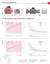
RANGER-UAV DIMENSIONS Operating Flight Altitude AGL White Marble White Marb e b Terracotta Terracot Terracot t Construction C s t Concre e Concrete Trees Co iferous Tre Coniferous Tre e Maximum Measurement Range (m) MAX MEASUREMENT RANGE & POINT DENSITY RANGER-UAV Target Reflectivity (%) EXAMPLE Ranger-UAV at 50k pulses/s Range to target = 400m, speed 6kn Operating Flight Altitude AGL W e Marble White Marb b @ visibility 23km @ visibility 15km @ visibility 8km Terracotta Terracot Terracot t Construction C s t Concre e Concrete Trees Co iferous Tre Coniferous Tre e Maximum Measurement Range (m)...
Open the catalog to page 2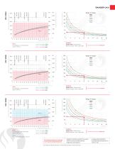
Operating Flight Altitude AGL White Marble Cliffs & Sand Deciduous Trees Construction Concrete Coniferous Trees Maximum Measurement Range (m) RANGER-UAV Range to Target Target Reflectivity (%) Operating Flight Altitude AGL White Marble EXAMPLE Ranger-UAV at 200k pulses/s Range to target = 180m, speed 10kn @ visibility 23km @ visibility 15km @ visibility 8km Cliffs & Sand Deciduous Trees Construction Concrete Coniferous Trees Maximum Measurement Range (m) MTA 1 No ambiguity / one transmitted pulse “in the air” Resulting Point Density 34 pts/m2 Target Reflectivity (%) White Marble Operating Flight...
Open the catalog to page 3
Operating Flight Altitude AGL White Marble Cliffs & Sand Deciduous Trees Construction Concrete Coniferous Trees Maximum Measurement Range (m) Target Reflectivity (%) MTA 1 No ambiguity / one transmitted pulse “in the air” @ visibility 23km @ visibility 15km @ visibility 8km EXAMPLE Ranger-UAV at 550k pulses/s Range to target = 100m, speed 8kn Resulting Point Density 210 pts/m2 The following conditions are assumed for the Operating Flight Altitude AGL • ambiguity resolved by multiple-time-around (MTA) processing and flight planning • target size ≥ laser footprint • average ambient brightness •...
Open the catalog to page 4All Phoenix LiDAR Systems catalogs and technical brochures
 RANGER XL
2 Pages
 RANGER ULTRA
2 Pages
 RANGER-LR LITE
2 Pages
 RANGER-HA
3 Pages
 RANGER-LR
4 Pages
 SCOUT ULTRA
2 Pages
 SCOUT-32
2 Pages
 SCOUT-16
2 Pages
 SCOUT-8
2 Pages
 RECON-A
2 Pages
 RECON-XT
2 Pages
 miniRanger-3 LITE
2 Pages
 Phoenix UAV LiDAR Systems
20 Pages
- Aeronautical software
- Real-time software
- Process software
- Maintenance software
- 3D software
- Cloud-based software
- Drone software
- Web-based software
- Data acquisition software
- Calculation software
- LIDAR laser
- Drone LIDAR laser
- Mapping LIDAR laser
- Data collection software
- Surveying LIDAR laser
- LIDAR software
- Measurement LIDAR laser
- 3D LIDAR laser
- Viewer software