- Catalogs
- Phoenix LiDAR Systems
- RANGER-HA
RANGER-HA

RANGER-HA
- Accuracy: Absolute accuracy of 25-35 mm RMSE at 250m range; PP Attitude Heading RMS Error of 0.007 / 0.009° with IMU options.
- Weight and Dimensions: Weighs 5.3 kg (11.7 lbs) with dimensions of 30.8 L x 18 W x 12.9 H (cm).
- Laser Range: 145 m at 1 mHz, 295 m at 500 kHz.
- Scan Rate: Up to 1 million shots per second with unlimited returns.
- Survey-grade accuracy with high point cloud density and intensity calibration.
- IMU and dual-GPS upgrade options for enhanced accuracy.
- Fully autonomous and can be mounted on any ground vehicle.
- Modular upgrade options including dual LiDAR sensors, DSLR, GeniCam, GigEVision, thermal, multispectral, hyperspectral, and custom sensors.
- Supports GPS + GLONASS constellations.
- Alignment options include static, kinematic, and dual-antenna.
- Operation modes include real-time and optional post-processing.
- Position accuracy of 1 cm + 1 ppm RMS horizontal.
- Rotating mirror scanning mechanism with mirror speed of 10-250 scans/sec.
- Angular step width between 0.0036° and 0.3°.
- Angle measurement resolution of 0.001°.
- Overall dimensions of the sensor are 308 x 180 x 129 mm; Nav Box dimensions are 161 x 118 x 96 mm.
- Operating voltage between 12 - 28 V with power consumption of 90 W.
- Weight including sensor and cabling is 5.44 kg (12 lbs).
- Operating temperature range from 0° to +40° C.
- Laser properties include 1550 nm Class 1 (eye safe).
- Minimum range of 1.2 m.
- Laser beam footprint varies from 4.5 mm at exit to 50 mm at 100 m.
- Maximum effective measurement rate of 1,000,000 measurements per second.
- Field of view is 360° with an accuracy of 5 mm one Sigma at 30m.
Catalog excerpts
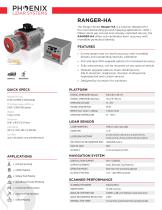
RANGER-HA The Ranger Series Ranger-HA is a solution designed for the most demanding ground mapping applications. With 1 Million shots per second and virtually unlimited returns, the RANGER-HA offers sub centimeter level accuracy with incredible pointcloud density. FEATURES » urvey-grade (sub cm-level) accuracy with incredible S density and outstanding intensity calibration » MU and dual-GPS upgrade options for increased accuracy I » ully autonomous, can be mounted on any ground vehicle F » odular upgrade options: Dual LiDAR Sensors, M DSLR, GeniCam, GigEVision, thermal, multispectral, hyperspectral and custom sensors » Designed by surveyors for surveyors QUICK SPECS Absolute Accuracy 25-35 mm RMSE @ 250m Range PP Attitude Heading RMS Error 0.007 / 0.009° IMU options Weight 5.3 kg / 11.7 lbs. Dimensions 30.8 L x 18 W x 12.9 H (cm) Laser Range 145 m @ 1 mHz, 295 m @ 500 kHz PLATFORM OVERALL DIMENSIONS (Sensor) OPERATING VOLTAGE POWER CONSUMPTION WEIGHT (incl. Sensor + cabling) OPERATING TEMPERATURE LiDAR SENSOR LASER PROPERTIES LASER BEAM FOOTPRINT MAX EFFECTIVE MEASUREMENT RATE Scan Rate up to 1 mio shots/s, up to unlimited returns NAVIGATION SYSTEM CONSTELLATION SUPPORT SUPPORT ALIGNMENT Static, Kinematic, Dual-Antenna OPERATION MODES Real-time, Post-processing optional ACCURACY POSITION » Utilities Mapping » Railway Track Mapping » Agriculture & Forestry Monitoring SCANNER PERFORMANCE SCANNING MECHANISM Rotating Mirror » Construction Site Surveying MIRROR SPEED » Open Pit Mining Operations ANGULAR STEP WIDTH ∆ϑ 0.0036° ≤ ∆ϑ ≤ 0.3° between consecutive shots ANGLE MEASUREMENT RESOLUTION INTERNAL SYNC TIMER for real-time synchronized time stamping of
Open the catalog to page 1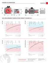
RANGER-HA DIMENSIONS @ visibility 23km @ visibility 15km @ visibility 8km Terracotta Terracot Terracot t Construction C s t Concre e Concrete Trees Co iferous Tre Coniferous Tre e Maximum Measurement Range (m) White Marble MTA 1 No ambiguity / one transmitted pulse “in the air” @ visibility 23km @ visibility 15km @ visibility 8km Cliffs & Sand Deciduous Trees Construction Concrete Coniferous Trees Maximum Measurement Range (m) Target Reflectivity (%) MTA 1 No ambiguity / one transmitted pulse “in the air” Target Reflectivity (%) Terracotta Terrac Terraco Construction C s t Concr Concrete Trees...
Open the catalog to page 2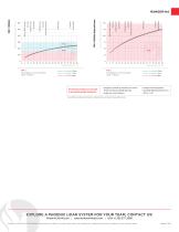
Terracotta Terraco Terraco Construction C s t Concr Concrete Trees Co iferous Tr Coniferous Tr Maximum Measurement Range (m) White Marble Cliffs & Sand Deciduous Trees Construction Concrete Coniferous Trees Maximum Measurement Range (m) Target Reflectivity (%) MTA 1 No ambiguity / one transmitted pulse “in the air” @ visibility 23km @ visibility 15km @ visibility 8km The following conditions are assumed for the Operating Flight Altitude AGL Target Reflectivity (%) MTA 1 No ambiguity / one transmitted pulse “in the air” • ambiguity resolved by multiple-time-around (MTA) processing and flight planning...
Open the catalog to page 3All Phoenix LiDAR Systems catalogs and technical brochures
 RANGER XL
2 Pages
 RANGER ULTRA
2 Pages
 RANGER-LR LITE
2 Pages
 RANGER-UAV
4 Pages
 RANGER-LR
4 Pages
 SCOUT ULTRA
2 Pages
 SCOUT-32
2 Pages
 SCOUT-16
2 Pages
 SCOUT-8
2 Pages
 RECON-A
2 Pages
 RECON-XT
2 Pages
 miniRanger-3 LITE
2 Pages
 Phoenix UAV LiDAR Systems
20 Pages
- Aeronautical software
- Real-time software
- Process software
- Maintenance software
- 3D software
- Cloud-based software
- Drone software
- Web-based software
- Data acquisition software
- Calculation software
- LIDAR laser
- Drone LIDAR laser
- Mapping LIDAR laser
- Data collection software
- Surveying LIDAR laser
- LIDAR software
- Measurement LIDAR laser
- 3D LIDAR laser
- Viewer software