- Catalogs
- Phoenix LiDAR Systems
- Phoenix UAV LiDAR Systems
Phoenix UAV LiDAR Systems

Phoenix UAV LiDAR Systems
Phoenix LiDAR Systems specializes in compact, flexible, survey-grade 3D laser mapping solutions. They are innovators in UAV LiDAR integration, real-time point cloud visualization, and automated cloud-based LiDAR post-processing, catering to industries like mining, forestry, utilities, oil and gas, and construction.
Phoenix LiDAR Systems provides adaptable solutions compatible with UAVs, vehicles, and boats. Their PLS SpatialExplorer software enables real-time data quality checks, minimizing data reacquisition needs. Their cloud-based platform automates post-processing, reducing time and costs.
Phoenix LiDAR offers several product series:
- Scout Series: Includes models like Scout-8 and Scout Ultra, offering various accuracy and point density levels for different applications.
- Pioneer Series: Features models like Pioneer P10, designed for high-resolution ground data and survey-grade mapping.
- Ranger Series: Includes models like Ranger XL, optimized for long-range, high-speed mapping.
The software suite includes tools for mission planning, data acquisition, and data fusion. Phoenix Flight Planner optimizes data quality and costs, while PLS SpatialExplorer provides real-time QA/QC and 3D point cloud colorization.
- Real-time 3D point cloud visualization with RGB fusion.
- Real-time LiDAR data analysis, including ground penetration and 3D measurements.
NavLab integrates IMU and GNSS data for accurate trajectory generation. Auto Flight Line Detection and LiDARSnap improve processing accuracy and efficiency, exporting aligned data in LAS files. LiDARMill offers automated cloud-based post-processing, reducing time and costs.
LiDARMill is a cloud-based platform for efficient LiDAR data processing, offering customizable solutions for organizations of any size, enabling faster turnaround and lower costs.
Catalog excerpts

MULTI PLATFORM SOLUTIONS
Open the catalog to page 1
Phoenix LiDAR Systems is a pioneer in the design and development of compact, develop the first UAV LiDAR integration prototype, introduced the first real time flexible, survey-grade 3D laser mapping solutions. We teamed with Velodyne to point cloud visualization software, and launched the first fully automated, cloud based LiDAR post processing solution. Our goal has always been to empower today’s generation of surveyors and engineers to deliver the highest quality work while saving time, reducing cost, and completing projects more easily. Phoenix systems are developed to be durable and flexible,...
Open the catalog to page 2
THE PHOENIX DIFFERENCE Adaptable & Flexible Enhanced Planning PLS payloads are designed for ease of integration with multiple platforms including UAV, multi-rotor and fixed wing VTOL UAS, vehicles, backpacks, manned aircraft, and boats, allowing you to collect data in the most challenging of situations. PLS flight planning software was specifically designed for UAV data acquisition, ensuring streamlined data collection resulting in less issues down the road. Real Time Visualization Automated Cloud Processing PLS SpatialExplorer enables you to view and QC in real time, colorized point cloud data...
Open the catalog to page 3
PRODUCT OVERVIEW Phoenix LiDAR offers the most extensive UAV LiDAR product portfolio of all UAV LiDAR manufacturers. The majority of our stand-alone surveying solutions are multi-platform, meaning the same system can be utilized on the ground and in the air, maximizing your return on investment. Scout Ultra Multi-Platform / SLAM Multi-Platform / SLAM Multi-Platform / SLAM Aerial Only Accuracy* Precision** Point Density No. Of Returns Altitude (AGL) Weight Price Platform Options *Accuracy is the degree of conformity of a measured quantity to its actual (true) value. ***All Ranger product overview...
Open the catalog to page 4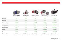
Accuracy Precision Point Density No. Of Returns Altitude (AGL) Weight Price Platform Options
Open the catalog to page 5
SCOUT-8 The Scout-8 is the newest addition to the Scout Series, taking cost-effective LiDAR scanning to new heights at up to 75 meters AGL and offering up to 3 returns. Customize your Scout-8 with photogrammetry, hyperspectral, thermal imaging, and additional options. Specifications • Distinction: Entry level UAV LiDAR solution. • Up to 75m AGL • 100mm RMSE @50m Range • 420k points/sec, up to 3 returns • 1.93kg / 4.25lbs • 18 x 11.6 x 11.6cm • Mounting Options: UAV, ground vehicle, backpack SLAM Included • LiDAR System: Integrated NavBox, Class 1 (eye safe), 905nm, M8 LiDAR Sensor, IMU-14/27...
Open the catalog to page 6
SCOUT-16 The Scout-16 is an excellent lightweight, entry-level system with a 40-meter recommended AGL. A strong fit for smaller scan areas and teams on a budget. Customize your Scout-16 with photogrammetry, hyperspectral, thermal imaging, and additional options Specifications • Distinction: Cost-effective and versatile • Up to 40m AGL • 55mm RMSE @ 40m Range • 300k points/sec, up to 2 returns • 1.65kg / 3.64lbs • 16.0 x 11.6 x 11.6cm • Mounting Options: UAV, ground vehicle, backpack, SLAM Included • LiDAR System: Integrated NavBox, Class 1 (eye safe), 905nm, VLP-16 LiDAR Sensor, IMU-14/27 • Navigation...
Open the catalog to page 7
SCOUT-32 The Scout-32 is a robust, mid-range member of the Scout Series. The lightweight system collects survey-grade data with an AGL range up to 65m. An excellent option for building high-density point clouds of smaller scan areas, customize your Scout-32 with photogrammetry, hyperspectral, thermal imaging, and additional options. Specifications • Distinction: Best accuracy (Scout Series) • Up to 65m AGL • 35-55mm RMSE @ 65m Range • 700k points/sec , up to 2 returns • 2.13kg / 4.7lbs • 24.6 x 11.6 x 11.6cm • Mounting Options: UAV, ground vehicle, backpack, SLAM Included • LiDAR System: Integrated...
Open the catalog to page 8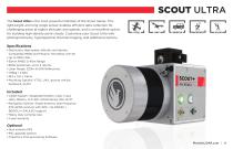
SCOUT ULTRA The Scout Ultra is the most powerful member of the Scout Series. This lightweight and long range sensor enables efficient data collection for challenging areas at higher altitudes and speeds, and is an excellent option for building high-density point clouds. Customize your Scout Ultra with photogrammetry, hyperspectral, thermal imaging, and additional options. Specifications • Distinction: High speed, altitude, and density. Compatible M600 and Phoenix TerraHawk CW-20 • Up to 100m AGL • 55mm RMSE @ 40m Range • 600k points/sec, up to 2 returns • Laser Range: 220m @ 60% Reflectivity...
Open the catalog to page 9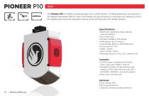
NEW The Pioneer P10 is a 1550nm purpose-built UAV LiDAR sensor. At 640k pulses per second and a 110 degree downward field of view, the Pioneer focuses all points on the ground, making it one of the highest ground point resolution sensor of all commercial UAV LiDAR systems Specifications • Distinction: Operating range, altitude, and point density • Up to 150m AGL • 20-30mm RMSE @ 75m Range • 640k points, up to 3 returns • Laser Range: 300m @ 20% Reflectivity • Horizontal FOV: 110° • 4.8kg / 10.6lbs • 24.6 x 20.39 x 7.8cm • Mounting Options: VTOL, UAV, Aerial SLAM Included • LiDAR System: Integrated...
Open the catalog to page 10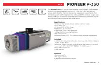
The Pioneer P-360 is a best-in-class universal survey grade LiDAR mapping system. With a measurement precision of <1cm, the P-360 will capture survey grade data for the most demanding application requirements. The complete system, with integrated dual oblique 24MPix cameras, weighs only 4.65kg; making it suitable for most mid-class commercial unmanned aircraft and robust enough for manned heli applications. Specifications • Distinction: High speeds, altitude, density, and return values • Up to 400m AGL • 25-50mm RMSE @ 350m Range • 500k points, up to 4 returns • Laser Range: 775m @ 30% Reflectivity...
Open the catalog to page 11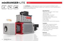
The miniRanger is a weight optimized version of our successful miniRanger system. Weighing only 2.2kg, the miniRanger enables users to add more camera upgrade options without sacrificing flight time. Specifications • Distinction: Light weight, compact design, ideal for the DJI M600 • Up to 75m AGL • 20-30mm RMSE @ 75m Range • 100k points, up to 5 returns • Laser Range: 250m @ 60% Reflectivity • Horizontal FOV: 360° • 2.2kg / 4.85lbs • 14 x 10 x 24.3cm • Mounting Options: ground vehicle, backpack Included • LiDAR System: Integrated Air NavBox, Class 1 (eye safe), 905nm, IMU-27 • Navigation System:...
Open the catalog to page 12All Phoenix LiDAR Systems catalogs and technical brochures
 RANGER XL
2 Pages
 RANGER ULTRA
2 Pages
 RANGER-LR LITE
2 Pages
 RANGER-UAV
4 Pages
 RANGER-HA
3 Pages
 RANGER-LR
4 Pages
 SCOUT ULTRA
2 Pages
 SCOUT-32
2 Pages
 SCOUT-16
2 Pages
 SCOUT-8
2 Pages
 RECON-A
2 Pages
 RECON-XT
2 Pages
 miniRanger-3 LITE
2 Pages
- Aeronautical software
- Real-time software
- Process software
- Maintenance software
- 3D software
- Cloud-based software
- Drone software
- Web-based software
- Data acquisition software
- Calculation software
- LIDAR laser
- Drone LIDAR laser
- Mapping LIDAR laser
- Data collection software
- Surveying LIDAR laser
- LIDAR software
- Measurement LIDAR laser
- 3D LIDAR laser
- Viewer software