- Catalogs
- Phoenix LiDAR Systems
- miniRanger-3 LITE
miniRanger-3 LITE

miniRanger-3 LITE
- Absolute Accuracy: 20 / 30 mm RMSE at 75 m Range
- PP Attitude Heading RMS Error: 0.018°
- Weight: 2.2 kg / 4.85 lbs
- Dimensions: 243 x 111 x 85 mm
- Laser Range: 290m at 60% Reflectivity
- Scan Rate: 300k shots/s, up to 5 returns
- Open Pit Mining Operations
- General Mapping
- Construction Site Surveying
- Utilities Mapping
- Agriculture & Forestry Monitoring
- Oil & Gas Surveying
- Railway Track Mapping
- Constellation Support: GPS, GLONASS, BEIDOU, GALILEO
- Support Alignment: Kinematic, Dual-Antenna
- Accuracy Position: 1 cm + 1 ppm RMS horizontal
- PP Attitude Heading RMS Error: 0.018° (IMU upgrades available)
- Overall Dimensions (Sensor): 243 x 111 x 85 mm
- Operating Voltage: 14 - 28 V DC
- Power Consumption: 35 W typical
- Operating Temperature: 0° - 40° C
- Weight (Including Air NavBox): 2.2 kg / 4.85 lbs
- Laser Properties: 905nm Class 1 (eye safe)
- Range Min: 2 m
- Max Effective Measurement Rate: Up to 300,000 meas./sec
- Horizontal Field of View: 360° at 100/200 kHz, 120° at 300 kHz
- Accuracy: 15 mm
- Max Measuring Range: 170 m (20% reflectivity), 290 m (60% reflectivity)
- Sensor Classification: IP64
- Weight: 1.55 kg
- Power Consumption: 18 W
- Designed for survey-grade LiDAR data and optional imagery on an ultra-lightweight platform
- 100 kHz, 200 kHz, and 300 kHz laser pulse repetition rate for greater point density at altitude
- Includes new AIR NavBox for increased range and flexibility
- 37% lighter than miniRANGER, providing increased range and flexibility
- Modular and upgradable, supporting various cameras and sensors
- Automated boresighting, strip matching, and project validation with LiDARMill
- Compatible with mobile and backpack mounting options
- Supports single/dual RGB, multispectral, and panoramic cameras
- Includes wheelsensor and SLAM options
- Website: PhoenixLiDAR.com
- Email: [email protected]
- Phone: USA +1.323.577.3366
Catalog excerpts

miniRanger-3 LITE The miniRanger-3 LITE is designed to provide survey-grade LiDAR data and imagery (optional) on an ultra-lightweight platform. Packed with options, the miniRanger-3 LITE leverages Phoenix’s years of experience and industry leading LiDARMill software platform to provide a seamless user experience. Optional mobile and backpack mounting options along with several imaging sensors provide the flexibility required to address every application. With the photogrammetry package, operators of mid-size multirotors, can now simultaneously acquire survey-grade LiDAR data and high resolution 61 MP photogrammetry at up to 100 m operating flight altitude. » 00 kHz, 200 kHz, and 300 kHz laser pulse repetition rate (PRR) for 1 greater point density at altitude » Includes the new AIR NavBox for increased range & flexibility » ignificantly lighter (37%) than miniRANGER providing increased range S and flexibility MOUNTING OPTIONS » odular and upgradable for maximum project flexibility, supporting M single/dual RGB, multispectral, and panoramic cameras, as well as wheelsensor and SLAM options » ultiple IMUs supported to customize the product to your project needs M QUICK SPECS » utomated boresighting, strip matching and project validation with LiDARMill A PLATFORM Absolute Accuracy 20 / 30 mm RMSE @ 75 m Range PP Attitude Heading RMS Error 0.018° Weight 2.2 kg / 4.85 lbs Dimensions 243 x 111 x 85 (mm) Laser Range 290m @ 60% Reflectivity Scan Rate 300k shots/s, up to 5 returns OVERALL DIMENSIONS (SENSOR) OPERATING VOLTAGE POWER CONSUMPTION OPERATING TEMPERATURE WEIGHT (INCLUDING AIR NAVBOX) LiDAR SENSOR LASER PROPERTIES MAX EFFECTIVE MEASUREMENT RATE » Oil & Gas Surveying » Utilities Mapping » Railway Track Mapping » Agriculture & Forestry Monitoring » Construction Site Surveying HORIZONTAL FIELD OF VIEW SENSOR CLASSIFICATION POWER CONSUMPTION NAVIGATION SYSTEM CONSTELLATION SUPPORT GPS + GLONASS + BEIDOU + GALILEO » General Mapping SUPPORT ALIGNMENT Kinematic, Dual-Antenna ACCURACY POSITION » Open Pit Mining Operations PP ATTITUDE HEADING RMS ERROR
Open the catalog to page 1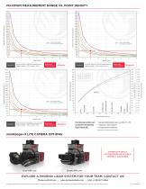
Average Point density (pts/m2) uniform point pattern non-uniform point pattern uniform point pattern non-uniform point pattern miniVUX-3UAV at 100,000 pulses/second, range to target = ~90 m, speed = 4m/s RESULTING POINT DENSITY miniVUX-3UAV at 2 00,000 pulses/second, range to target = ~90 m, speed = 4m/s RESULTING POINT DENSITY coniferous trees uniform point pattern non-uniform point pattern white masonry deciduous trees yellow beach sand Average Point density (pts/m2) @ visibility 23 km @ visibility 15 km @ visibility 8 km Operating Flight Altitude [m] Target Reflectance (%) miniVUX-3UAV at 300,000...
Open the catalog to page 2All Phoenix LiDAR Systems catalogs and technical brochures
 RANGER XL
2 Pages
 RANGER ULTRA
2 Pages
 RANGER-LR LITE
2 Pages
 RANGER-UAV
4 Pages
 RANGER-HA
3 Pages
 RANGER-LR
4 Pages
 SCOUT ULTRA
2 Pages
 SCOUT-32
2 Pages
 SCOUT-16
2 Pages
 SCOUT-8
2 Pages
 RECON-A
2 Pages
 RECON-XT
2 Pages
 Phoenix UAV LiDAR Systems
20 Pages
- Aeronautical software
- Real-time software
- Process software
- Maintenance software
- 3D software
- Cloud-based software
- Drone software
- Web-based software
- Data acquisition software
- Calculation software
- LIDAR laser
- Drone LIDAR laser
- Mapping LIDAR laser
- Data collection software
- Surveying LIDAR laser
- LIDAR software
- Measurement LIDAR laser
- 3D LIDAR laser
- Viewer software