- Catalogs
- MULTIROTOR service-drone.de GmbH
- SURVEYING-ROBOT
SURVEYING-ROBOT

SURVEYING-ROBOT
The Surveying-Robot by MULTIROTOR is an all-in-one UAV solution for surveying and inspection, first introduced in 2014. It is available in four package solutions tailored for different needs, offering impressive flight times and wind stability. The robot is equipped with flight planning software for easy mission planning and can be enhanced with thermal imaging and multispectral cameras for expanded applications.
The Surveying-Robot comes in models S, M, L, and XL, each with specific features such as detachable propellers, live telemetry, and optional cameras. The XL model offers a longer flight time of 32 minutes. Optional accessories include the Optris PI LightWeight 640 IR camera and Tetracam ADC-Micro multispectral camera, enhancing the robot's capabilities in various sectors.
The Surveying-Robot simplifies surveying operations by reducing the need for numerous control points, thus saving time and costs. It is capable of generating detailed orthophotos, digital elevation models, and 3D models. The robot's precision and reliability make it suitable for use in challenging weather conditions and diverse applications such as landfill surveying and photovoltaic system monitoring.
Founded in 2011, MULTIROTOR is a market leader in professional multi-rotor drones, known for its innovative solutions and high-quality service. The company focuses on developing integrated systems for various industries, ensuring reliability and safety in its products.
The Surveying-Robot features advanced flight electronics, including a 32-bit dual processor for precise altitude control, GPS flight assistance, and redundancy for safe operations. It can perform autonomous flights over large areas and maintain stability in high winds.
Catalog excerpts

SURVEYING-ROBOT Product Overview and Features
Open the catalog to page 1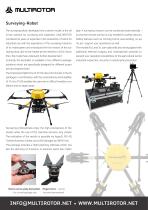
Surveying-Robot The surveying-robot, developed into a series model, is the all- play. A surveying mission can be conducted automatically – in-one solution for surveying and inspection. MULTIROTOR so that the remote control is only needed for safety reasons. combined its years of expertise in the production of UAVs for Safety features such as Coming Home, auto-landing, no pa- industrial use with the experience of the surveying missions nic etc. support your operations as well. of its multicopters and introduced the first version of the sur- The models M,L and XL can optionally also be equipped...
Open the catalog to page 3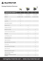
Package Solutions Overview SURVEYING-ROBOT Flight time Batteries Detachable propellers Analogue video link Jeti DC16 with monitor mount Foldable propellers Digital video link Sony Alpha 6000, incl. 2nd lens Video start/stop from station Additional tripod for monitor Optional thermal imaging camera possible Optional multispectral camera possible
Open the catalog to page 4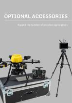
OPTIONAL ACCESSORIES Expand the number of possible applications
Open the catalog to page 5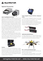
Optional Accessories System integration Tetracam ADC-Micro multispectral Optris PI LightWeight 640 IR camera Expand your possibilities by integrating the Optris PI Light- In case you need a multispectral camera for your opera- Weight 640 IR thermal imaging camera, specially designed for tions, we can offer you the integration of your Tetracam flight operations, as a second camera for the drone. The light- ADC-micro multispectral camera for your drone. weight thermal imaging camera offers a very good price-per- Discover new fields of application in the agricultural sector, formance ratio compared...
Open the catalog to page 6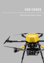
USE CASES The Surveying-Robot in Action
Open the catalog to page 7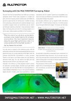
Surveying with the MULTIROTOR Surveying-Robot Discover, how the Surveying-Robot can make your surveying calculations and 3D models. Expand your possibilities, your operations easier. Precise data acquisition in complex pro- value chain and your efficiency with the MULTIROTOR G4 Sur- jects with old surveying sensors (tachymeter and GNSS) de- veying-Robot Ready-to-fly packet! pends on a great number of control points. In addition to being Add standard softwares such as Agisoft, Pix4D, UAS Mana- time consuming, control points are a potential danger to your ger by INPH, Trimble Business Center etc....
Open the catalog to page 8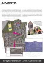
The precision and quality of our surveying products has alrea- There is also a variety of additional useful equipment. Choo- dy convinced a great number of surveyors, mining companies se individual training sessions for small groups of operators and even forensic teams. Even under bad weather conditions or one-on-one coaching, product insurance to protect invest- with a wind strength of up to 15m/s, altitudes of up to 4,700m ments and a maintenance contract with a support-hotline or above sea level and ranges of up to 3,500m, the UAVs remain the MULTIROTOR G4 software license full-upgrade in...
Open the catalog to page 9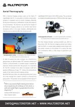
Aerial Thermography With a thermal imaging camera, such as the Optris PI LightWeight 640 IR and a GoPro RGB camera. This combinati- LightWeight 640 IR, it is possible to monitor photovoltaic on enables the parallel generation of RGB and thermal images. systems in operation and to correct mistakes efficiently. During live-monitoring a combination of pilot and observer is recommended. The observer can see the live images of the thermal imaging camera on a monitor and hence recognise errors in the solar modules. Alternatively, the material can be watched after the mission as well. Exchangegimbal...
Open the catalog to page 10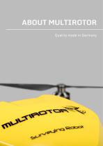
ABOUT MULTIROTOR Quality made in Germany
Open the catalog to page 11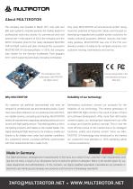
About MULTIROTOR The company was founded in March 2011 and, with over Very early MULTIROTOR service-drone.de GmbH recog- 800 sold systems, instantly became the market leader for nised the potential of flying UAV robots and focused on professional multi-rotor drones for commercial and insti- developing integrated and scalable system solutions for tutional use. In the autumn of 2014, the company won the media, industrial purposes, defense, security and espe- ARTIE innovation prize for the newly developed MULTIRO- cially geodesy. MULTIROTOR was one of the first wor- TOR G4 flight control and also...
Open the catalog to page 12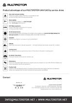
Product advantages of our MULTIROTOR UAV/UAS by service-drone Auto-start and auto-landing Thanks to a great number of sensors it is possible to start and land the MULTIROTOR fully automatically. Wind stability Our drones fly reliably in a wind strength from 10-15 m/s (36-54 km/h). GPS flight assistance Unique GPS flight assistance for manual of fully automatic flights. 32-bit dual processor The 32-bit dual processor technology of our flight-control registers and corrects the flight altitude 512 times per second and enables the possibly safest drone flight of all times. Autopilot Autonomous flights...
Open the catalog to page 13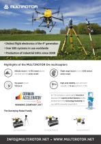
■ Distinct flight electronics of the 4th generation ■ Over 800 systems in use worldwide ■ Production of industrial UAVs since 2008 Highlights of the MULTIROTOR G4 multicopters Altitude record of 4,700 meters above Flight range record of over 3.500 meters sea level with the series model action scope High wind stability even with wind » The company is particularly innovative because of its superior product features and the achievement of the technology leadership Jury ARTIE innovation award 2014
Open the catalog to page 14All MULTIROTOR service-drone.de GmbH catalogs and technical brochures
 MULTIROTOR G4 Eagle
6 Pages
