- Catalogs
- MICROSTEP-MIS
- IMS4 Model Suite
IMS4 Model Suite

IMS4 Model Suite
- High Availability and integration with various data sources for seamless operation.
- Support for a wide range of models including Numerical Weather Prediction, Nowcasting, Dispersion Models, and more.
- Advanced visualization and model validation tools for easy interpretation and quality monitoring.
- High Performance Computing support for demanding simulations.
- Numerical Weather Prediction: Provides 3D regional weather forecasts with high resolution.
- Dispersion Models: Simulate pollutant and radioactivity dispersion across various scales.
- Road/Runway Condition Model: Forecasts road and runway conditions, particularly under winter conditions.
- Fog Prediction: Utilizes 3D meteorological models and experimental methods for fog forecasting.
- Sandstorm Modeling: Predicts sandstorm events using advanced numerical weather prediction techniques.
- Hydrological Modeling: Includes rainfall-runoff and hydraulic models for water level and discharge forecasting.
- Visualization and map services for easy data interpretation.
- Model validation tools for monitoring simulation quality.
- Data mining capabilities for training neural networks and decision trees.
- Comprehensive training and support services.
Catalog excerpts

Complex Monitoring and Forocesting Suite
Open the catalog to page 1
High resolution, short term weather forecasting and Radiation and pollutant crisis modeling Road condition modeling Visibility modeling Sand storm modeling Hydrological modeling The IMS4 Model Suite provides a composition of modern models and simulation technologies for meteorology, hydrology, radiation and air quality. Models run both operatively and in research mode. IMS4 Model Suite is an integrated, easy-to-use, powerful system for modeling, processing, visualisation and model validation. IMS4 Model Suite is a complex system for supporting forecasters as well as crisis managers. Its application ranges...
Open the catalog to page 2
IMS4 Model Suite The main users of the system are usually meteorologists, hydrologists or authorities responsible for the crisis management at local, regional or national levels. The optional subsystems include but are not limited to call center with digital recording systems, GIS, warning and notification systems. The models and data bases comply with international standards in the respective areas, however they can be customized to meet the geographical, climatic, environmental as well as organizational specifics of the customer. Numerical Weather Prediction Models NWP Model provides forecast...
Open the catalog to page 3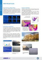
IMS4 Model Suite Road / Runway Condition Model Sandstorm Modeling Road/Runway Condition Model is suitable for prediction of potential risk on roads or runways caused by winter conditions. Model provides nowcasting and/or short term forecasting of road/runway condition based on radiation and heat budgets. It is very powerful tool for supporting road maintenance during winter season. Sandstorm model is based on the state-of-the-art of the 3D numerical weather prediction and the model for sand uplift, dispersion and deposition. It is verified against geostationary and polar orbiting satellites,...
Open the catalog to page 4
Hydrological Modeling The complex network of models is used for the water level and discharge forecast or 1-D/2-D hydrodynamic calculations. The variety of models is ranging from simple empirical formulas to rainfall-runoff or hydraulic models with deterministic or ensemble data sets. The advanced system for models configuration and management is a part of the IMS4 Model Suite. The data visualization and processing is also fully integrated into the hydrological portal. Following hydrological models have been integrated in order to enable the user to solve wide range of hydrological issues in...
Open the catalog to page 5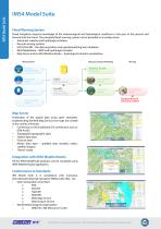
IMS4 Model Suite Flood Warning System Flood mitigation requires knowledge of the meteorological and hydrological conditions in the past, at the present and forecast into the future. The complete flood warning system can be provided on a turnkey basis: • Automatic weather and hydrological stations • Remote sensing systems • UDCS/EnviDB – the data acquisition and operational/long term database • IMS4 ModelSuite – NWP and hydrological models • Map Server and/or IMS4 WeatherStudio – hydrological situation visualization Measurement Data processing & Modeling Weather Studio Automatic weather stations...
Open the catalog to page 6All MICROSTEP-MIS catalogs and technical brochures
 MMR-116
3 Pages
 Ultrasonic Anemometer 3D
2 Pages
 Ultrasonic Anemometer 2D
3 Pages
 RT1
RT11 Page
 IMS4 ATIS / VOLMET
4 Pages
 RHT175
2 Pages
 IMS4 MetReporter
4 Pages
 IMS4 RVR
2 Pages
 IMS4 ARWIS
4 Pages
 MM10
MM102 Pages
 IMS4 AWOS
6 Pages
 IMS LITE
2 Pages
 IMS Observer Workstation
2 Pages
 SWS-200
2 Pages
 SWS-100 Visibility Sensor
2 Pages
 Active Road Sensor ARS31
1 Page
 IRS31 Pro
1 Page
 IMS4 LLWAS
4 Pages
 IMS4 AWDSS
4 Pages
 IMS4 ARWIS 2014
4 Pages
 IMS4 ATIS / VOLMET 2015
4 Pages
 IMS CLDB
8 Pages
 MWD-30A
1 Page
 IMS4 AMS 111 II
4 Pages
 SAWS 111
2 Pages
 RHT75
RHT751 Page
 PT100D
1 Page


- KENNAMETAL aeronautic software
- Airport lighting system
- Runway beacon
- KENNAMETAL real-time software
- KENNAMETAL airport software
- Maintenance software
- KENNAMETAL cloud software
- Navigation software
- Surveillance radar
- KENNAMETAL mapping software
- Automated software
- Airport radar
- EFIS
- Aircraft EFIS
- Server software
- KENNAMETAL collaborative software
- Cutting software
- Meteorological software
- Airport weather station
- Battery charger