- Catalogs
- Inertial Labs, Inc.
- RESEPI Product Brochure 2025
- Company
- Products
- Catalogs
- News & Trends
- Exhibitions
RESEPI Product Brochure 2025

RESEPI Product Brochure 2025
- System Accuracy: Achieves a vertical accuracy of 1.5 cm RMSEZ at 120 m.
- Range Accuracy/Precision: 10 mm / 5 mm.
- Recommended AGL: Up to 205 m.
- Weight and Dimensions: Weighs 1.2 kg with dimensions of 17 x 14.4 x 11 cm.
- Max Flight Time: 33 minutes with DJI M350.
- Storage: Internal 512GB SSD and removable USB.
- Power Consumption: Up to 60W, operational voltage range of 9-50V.
- Compliance: IP54, CE, RoHS, WEEE, REACH, NDAA.
- Camera: Embedded 5MP and external 61 MP options.
- Remote Sensing: Utilized for 3D laser scanning in terrestrial, airborne, and mobile applications.
- Utility Inspection: Drones equipped with LiDAR and photogrammetry offer cost-effective and safer inspection methods.
- SLAM Algorithm Development: Real-time point cloud generation aids in SLAM development.
- Construction Site Monitoring: Enables regular project progress monitoring with RGB cameras and LiDAR technology.
- Precision Agriculture: Assists in developing 3D farmland models, crop planning, and resource mapping.
Catalog excerpts

PRODUCT BROCHURE
Open the catalog to page 1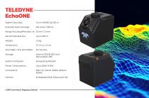
System Accuracy Example Area Coverage Range Accuracy/Precision, 1o Recommended AGL Weight Dimensions Max Flight Time (DJI M350) Storage System Computer Power Consumption Compliance Camera 1.5 cm RMSEZ @ 120 m 814 acres / 329 ha 10 mm / 5 mm Up to 205 m 1.2 kg IP54, CE, RoHS, WEEE, REACH, NDAA LiDAR Scanning & Mapping Solution
Open the catalog to page 2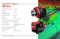
RESEPI™ GEN-II System Vertical Accuracy (1o Noise Removal) Recommended AGL Weight Dimensions Max Flight Time (DJI M350) Internal Storage System Computer Operational Voltage Range Power Consumption Camera LiDAR Scanning & Mapping Solution
Open the catalog to page 3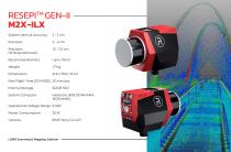
RESEPI™ GEN-II System Vertical Accuracy 2 - 3 cm Recommended AGL Weight Dimensions Max Flight Time (DJI M350) 33 minutes Internal Storage 512GB SSD System Computer Operational Voltage Range 9-50V LiDAR Scanning & Mapping Solution
Open the catalog to page 4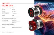
System Vertical Accuracy (1o Noise Removal) Recommended AGL Weight Dimensions Max Flight Time (DJI M350) Internal Storage System Computer Operational Voltage Range Power Consumption Camera 2 - 3 cm 2 - 4 cm Quad Core, 1GB RAM, 8GB eMMC LiDAR Scanning & Mapping Solution
Open the catalog to page 5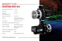
RESEPI™ LITE— System Vertical Accuracy (1o Noise Removal) Recommended AGL Weight Max Flight Time (DJI M350) External Storage System Computer Operational Voltage Range Power Consumption Camera Quad Core, 1GB RAM, 8GB eMMC LiDAR Scanning & Mapping Solution
Open the catalog to page 6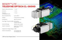
RESEPI™ LITE- System Vertical Accuracy Weight 4.3 kg (without camera) Max Flight Time (DJI M350) 23 minutes External Storage 256GB USB Included System Computer Quad Core, 1GB RAM, Operational Voltage Range 9-36V LiDAR Scanning & Mapping Solution
Open the catalog to page 7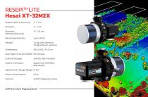
RESEPI™ LITE- System Vertical Accuracy (1o Noise Removal) Recommended AGL Weight Max Flight Time (DJI M350) External Storage System Computer Operational Voltage Range Power Consumption Camera 2 - 3 cm 2 - 4 cm 1.5 - 2.5 cm Quad Core, 1GB RAM, 8GB eMMC LiDAR Scanning & Mapping Solution
Open the catalog to page 8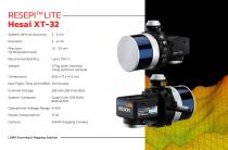
RESEPI™ LITE System Vertical Accuracy (1o Noise Removal) Recommended AGL Weight Max Flight Time (DJI M350) External Storage System Computer Operational Voltage Range Power Consumption Camera 2 - 3 cm 2 - 4 cm 1.5 - 2.5 cm Quad Core, 1GB RAM, 8GB eMMC LiDAR Scanning & Mapping Solution
Open the catalog to page 9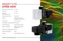
RESEPI™ LITE System Vertical Accuracy (1o Noise Removal) Recommended AGL Weight Max Flight Time (DJI M350) External Storage System Computer Operational Voltage Range Power Consumption Camera Quad Core, 1GB RAM, 8GB eMMC LiDAR Scanning & Mapping Solution
Open the catalog to page 10
REMOTE SENSING WITH LIDAR UTILITY INSPECTION Sometimes called a 3D laser scanner, LiDAR is a surveying method that measures the distance to a target by illuminating the target with pulsed laser light and measuring the reflected pulses with a sensor. It has terrestrial, airborne, and mobile applications. Some models of 3D automotive LiDAR (used in cost effective aerial mapping) can generate up to 1,920,000 points per second. There are plenty of exceptional producers on the market, for example, Hesai®, Quanergy® and Velodyne®. Perhaps area mapping is still the most significant domain for remote...
Open the catalog to page 11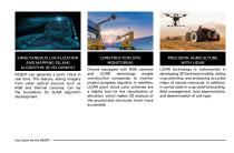
SIMULTANEOUS LOCALIZATION AND MAPPING (SLAM) ALGORITHM DEVELOPMENT RESEPI can generate a point cloud in real time. This feature, aiding imagery from other optical sources such as RGB and thermal cameras, can lay the foundation for SLAM algorithm development. CONSTRUCTION SITE MONITORING Drones equipped with RGB cameras and LiDAR technology enable construction companies to monitor project progress regularly. In addition, LiDAR point cloud color schemes are a helpful tool for the visualization of elevation, which makes 3D analysis of the ground and structures much more accessible. PRECISION AGRICULTURE...
Open the catalog to page 12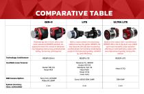
COMPARATIVE TABLE Technology Architecture ULTRA LITE Powered by Gen-II Core, this is the most advanced RESEPI solution designed to meet the needs of demanding mapping and survey professionals today, tomorrow, and beyond. With a vast number of units being utilized across the globe, RESEPI Lite has become the solution trusted by professionals for tackling challenging projects that demand quality, reliability, and efficiency. Built on the robust Gen-I architecture, RESEPI Ultra Lite is the best Low-SWoP and most versatile Lidar solution offering an extraordinary value with uncompromised quality...
Open the catalog to page 13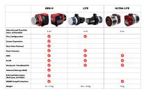
Data Internal Precision (max. achievable) ULTRA LITE Flex Configuration Sensor Expansion Real-time Protocol Dual-Antenna MMS SLAM Backpack / Handheld Kit Onboard Storage (SSD) External Data Comm (MAVLink, DJI PSDK) RESEPI SnapFit Interface Weight
Open the catalog to page 14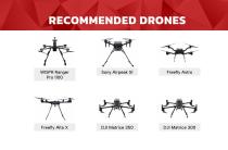
RECOMMENDED DRONES Freefly Astro
Open the catalog to page 15
RESEPI™ (Remote Sensing Payload Instrument) is a sensor-fusion platform designed for accuracy-focused remote sensing applications. RESEPI utilizes a high-performance Inertial Labs INS (GPS-Aided Inertial Navigation System) with a tactical-grade IMU and a high-accuracy single or dual-antenna GNSS receiver, integrated with a Linux-based processing core and data-logging software. The platform also provides a WiFi interface, optional imaging module, and external cellular modem for RTCM corrections. RESEPI can be operated by a single hardware button or from a wirelessly connected device via a simple...
Open the catalog to page 16All Inertial Labs, Inc. catalogs and technical brochures
 Products Catalog 2025
56 Pages
- Inertial system
- IMU inertial system
- Drone gyroscope system
- High-accuracy inertial system
- MEMS inertial system
- AHRS inertial system
- GNSS inertial system
- INS inertial system
- 3-axis inertial system
- Miniature inertial system
- Navigation inertial system
- ITAR-free inertial system
- Avionics instrument inertial system
- Inertial system with integrated GPS
- LIDAR laser
- Drone LIDAR laser
- Mapping LIDAR laser
- Surveying LIDAR laser
- Measurement LIDAR laser
- GNSS LIDAR laser