- Company
- Products
- Catalogs
- News & Trends
- Exhibitions
EuroNav 7
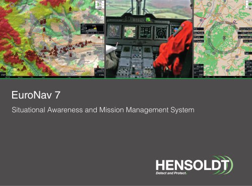
EuroNav 7
HENSOLDT Avionics provides an integrated solution for both airborne and ground assets through the EuroNav 7 system, enhancing mission execution for manned and unmanned platforms with improved flexibility and situational awareness.
- Moving Map: Features include HTAWS, obstacle and airspace warnings, traffic overlay, and radar overlay.
- Situational Awareness: Offers interoperability with various interfaces, dual head functionality, and multiple mission tools.
- Mission Management: Includes a map engine, database search, overlays, and an intuitive human-machine interface.
- Hardware: Dual head capability, modular architecture, and various electrical interfaces.
- Connectivity: Supports WLAN, 3G/UMTS, SatCom, and interfaces with external communication devices.
- Software Modules: Expandable with hardware and software modules for enhanced performance.
HENSOLDT Avionics offers a map subscription service with global coverage, providing regular updates and customization options.
Includes keyboards, control units, and mounting trays designed for ergonomic use and easy installation.
The EuroNav 7 system is a comprehensive solution for mission management, offering advanced features for situational awareness and connectivity, supported by robust hardware and software infrastructure.
- Weight and Dimensions: 1.85 kg (4.08 lbs), 76 (H) x 146 (W) x 212.6 (D) mm
- Operating Voltage: 28V DC nominal, 22-30.3V DC range
- Mounting: Upright with DZUS fasteners
- Slots: Slot A for 2.5” SSD, Slot B for Extension Module
- Antenna Interfaces: DGPS, GPS/GALILEO, WLAN
- Electrical Interfaces: Includes serial, audio, USB, ARINC, Ethernet, and more
- Video Interfaces: VGA, DVI-D/HDMI, PAL/NTSC, SDI
- Weight and Dimensions: 0.3 kg (0.66 lbs), 57 (H) x 146 (W) x 64.2 (D) mm
- Operating Voltage: +12 VDC nominal
- Mounting: All axes with DZUS fasteners
- Material: Aluminum, black
- Panel NVG Classification: NVIS Type I, Class A
- Button Features: 8 buttons, white text, dimmable illumination
- Keyboard CLATMN: 0.45 kg, plastic case
- Keyboard CLATMN 3.0: 1.550 kg, aluminum case, IP67 sealed
- Solid-State-Drive: 256/512 GB, 2.5” form factor
- Mounting Tray HNR-7.0: 0.66 kg, vertical mounting
- Mounting Tray HNR-7.1: 1.05 kg, horizontal mounting
- HENSOLDT Avionics GmbH: Pforzheim, Germany
- HENSOLDT Avionics UK: West Sussex, UK
- HENSOLDT Avionics USA LLC: Sarasota, FL, USA
- HENSOLDT Avionics CH: Sissach, Switzerland
Catalog excerpts
EuroNav 7 Situational Awareness and Mission Management System
Open the catalog to page 1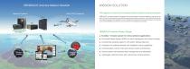
HENSOLDT Avionics Mission Solution MISSION SOLUTION Full integration of manned and unmanned airborne platforms and ground assets HENSOLDT Avionics provides an integrated end-to-end solution for airborne platforms and ground assets. This goal is achieved by transparently supporting the mission execution, and allowing both ground and airborne assets to be integrated in a joint architecture. Manned and unmanned systems are teamed up to provide flexibility and ease of use at a maximum of situational awareness. ■ EuroNav 7 mission system for critical airborne applications ■ Enhanced Reality System...
Open the catalog to page 2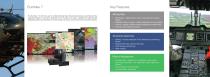
EuroNav 7 Key Features The EuroNav 7 is the first Level C certified Moving Map, Situational Awareness and Mission Management System. It has been designed from the outset as a robust, capable and highly flexible integrated system that interfaces to a wide range of avionics, sensors and communication devices. Moving Map • Map Engine - displays raster, vector, terrain data and satellite images • Database & Search Engine - different databases can be installed • Overlays - display multiple maps and databases simultaneously • Intuitive Human Machine Interface Situational Awareness • HTAWS - includes...
Open the catalog to page 3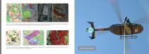
Map Engine The EuroNav 7 system processes and displays raster, vector and terrain data as well as satellite pictures and aerial photographs. A high performance map engine guarantees fast update rates and smooth panning and zooming of maps. Databases The EuroNav 7 accepts a broad range of map types such as Obstacles DB, Air Navigation DB, Terrain Data, POIs, Street and Topographic maps and even user created maps and databases.
Open the catalog to page 4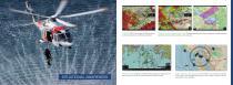
HTAWS ETSO-C194 certified HTAWS (Helicop- Obstacles and Airspace Warnings Obstacle Warnings for collision avoidance. Airspace Warning ter Terrain Awareness and Warning System). alerts the operator before entering a new airspace. SITUATIONAL AWARENESS Radar Overlay Weather and Search Radar outputs are supported and can be shown on top of the map with other information layers. Traffic Overlay and Warning The EuroNav 7 can receive and display TCAS, ADS-B, and FLARM traffic data as a map overlay. A caution and warning system is also available.
Open the catalog to page 5
Dual Head Output • Control Panel GPS/Glonass/Galileo antenna Interoperability The EuroNav 7 offers a wide and extremely flexible range of interfaces to interact with third party equipment, sensors and communication devices. These interfaces allow information and data to be exchanged, processed and dis
Open the catalog to page 6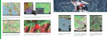
AIS Identification and marking of tracked vessels on the map. Display of AIS target information, such as type, size, position, and heading. Flight Planning and FMS Create and store flight plans. Share flight plans bi-directionally with the FMS. Dual Head Capability The EuroNav 7 provides independent video output and control for both pilot and co-pilot, or cockpit and cabin. Intervisibility A tactical application that indicates if the aircraft is detectable by a defined position depending on terrain and aircraft altitude. Search and Holding Pattern Predefined or fully configurable search and holding...
Open the catalog to page 7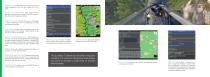
Marker Function Markers are points, lines, and areas. Object appearance, title, and other details can be modified. Digital Video Recorder A single channel DVR is standard on the EuroNav 7 system. The DVR records video streams from supported devices. Flight Information Provides the operator with airport or NavAid information such as frequencies, services, and runway information. User Objects Points, lines and polygons can be created and stored in the EuroNav 7, either directly on the map or by entering coordinates. Internal Positioning Reference The EuroNav system has an internal GPS/GLONASS/GALILEO...
Open the catalog to page 8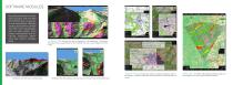
By adding hardware and software modules, both the RN7 and RN7CM are configurable and expandable. Modules replace stand-alone systems and offer many advantages, such as lower weight, lower power consumption and enhanced situational awareness and mission management. :d apch: Climb on rwy track continue climb to 5000' vi; JeppView Module Viewing and overlay of Jeppesen JeppView charts in ARINC 708 The ARINC 708 integrates Weather Radar and the EuroNav 7 Approach, departure and airport charts can be accessed and other systems as a map overlay within the EuroNav 7.
Open the catalog to page 9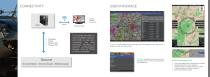
CONNECTIVITY USER INTERFACE DEFAULT • Mission Data • Tracking Info Ground Tools Ground Ground Station | Ground Assets | Mobile Assets Airports on Current Route The EuroNav provides onboard 3G/UMTS, SatCom, and WLAN for data communication and data exchange. Interfaces to external communication devices, such as TETRA or AIS are available. KARLS RU HE/BAD E N-BADEN Airports near Current Route Terrain Profile. Kneeboard Keeps flight-pertinent information such as Navigation Cards, Airspace Info, Frequency Cards etc. close at hand. My Menu Frequently used functions can be combined within one menu to...
Open the catalog to page 10
Key Features • Dual head capability - two independent video outputs and controls • Modular architecture with up to three slots for extension modules • Broad range of electrical interfaces - connection to avionics systems and sensors • Several analog and digital video interfaces - support for existing and new cockpit architectures • • • • GPS/GLONASS/Galileo - flexibility and redundancy 3G/UMTS (RN7 only) - communication out of the box WLAN - wireless upload of updates and download of recorded data Digital Video Recorder (DVR) Compact and lightweight design Designed according to RTCA/DO-254 Level...
Open the catalog to page 11
HARDWARE MODULES SatCom Module Allows making/receiving calls, sending/receiving messages and delivering automatic position reports to ground assets. FLARM Module This traffic and collision warning system uses the integrated FLARM module to show the positions of other FLARM equipped aircraft. AIS Rx Module The EuroNav 7 supports Automatic Identification System (AIS) functionality to increase efficiency and safety especially while flying off-shore missions. AIS Module, FLARM Module 3G/UMTS The internal 3G/UMTS chip and SIM card slot enable mobile communications (calls, messages, and remote downloads)...
Open the catalog to page 12All HENSOLDT catalogs and technical brochures
 ARGOS-II Airborne EOS
2 Pages
 ARGOS-8 Airborne EOS
2 Pages
 Video Management and ERS
17 Pages
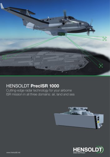 PrecISR Airborne Radar
2 Pages
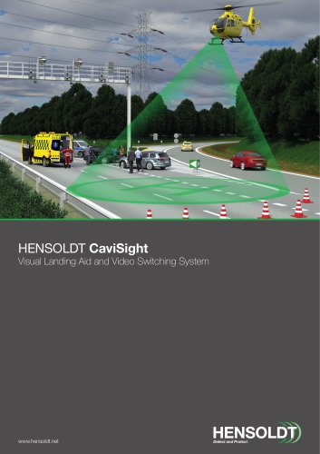 CaviSight
2 Pages
 CaviConnect
2 Pages
 HENSOLDT SferiRec LCR 100
2 Pages
 Multipurpose Antenna
1 Page


- Aircraft antenna
- Pilot glasses
- UAV camera
- Surveillance radar
- Safety glasses
- Blade antenna
- Aircraft camera
- Aircraft radar
- Airborne radar
- Microfiber glasses
- Inflight connectivity
- Aircraft inflight connectivity
- Flight data recorder
- Ruggedized camera
- Stabilized camera
- Tracking camera
- Aircraft flight data recorder
- DVR video recorder
- Aircraft video recorder
- WiFi inflight connectivity