- Catalogs
- Gis Design S.r.l.
- Company Profile - Eng - Gis Design
Company Profile - Eng - Gis Design
Company Profile - Eng - Gis Design
Vision: To impact the global stage by providing reliable solutions and high-quality engineering services through a skilled team.
Mission: To contribute significantly to the engineering sector, focusing on sustainable growth while balancing resource quality and innovation.
Values: Achieving client goals with responsibility, enthusiasm, and passion.
Founded in 2002 by Filippo and Fabio Colombrita, GIS Design S.R.L. specializes in engineering services using BIM methodology. In 2017, it merged with the family construction business to form Ingegneria Costruzioni Colombrita S.R.L., emphasizing continuous improvement and customer satisfaction.
GIS Design is dedicated to continuous improvement, stakeholder engagement, process optimization, and risk minimization. It holds certifications in public works, health and safety, quality management, gender equality, ethical behavior, and environmental management.
The Board provides strategic leadership, ensuring decisions align with values and long-term goals. Department managers implement the Board’s vision, overseeing daily operations and optimizing processes.
GIS Design excels in topographic surveys using advanced tools, ensuring precision and reliability. They conduct infrastructure, aerophotogrammetric, and network infrastructure surveys.
The company offers technical services for investigations, tests, and monitoring, focusing on seismic vulnerability and structural diagnosis.
Specializing in sustainable infrastructure projects like roads, railways, and airports, GIS Design uses BIM methodology for comprehensive project management.
Focusing on sustainable building design, GIS Design addresses energy and environmental challenges, engaging in restoration projects with an emphasis on historical preservation and innovative technologies.
GIS Design integrates Geographic Information Systems (GIS) and Building Information Modeling (BIM) to enhance communication, cooperation, and project optimization throughout the lifecycle of built structures, emphasizing 3D architectural design and professional renderings.
With extensive experience in GIS and web-GIS design, GIS Design collaborates with major software houses and clients like ANAS and the University of Catania. The integration of GIS and BIM enhances understanding of interactions between built and natural environments, optimizing data exchange between BIM, CAD, and GIS.
Specializing in inspections using advanced tools like drones and laser scanners, GIS Design complies with guidelines for risk classification and safety assessment, integrating valuable data into GIS projects for maintenance and decision-making.
For over 20 years, GIS Design has contributed to road safety through coordinated actions addressing road accidents, supporting road management bodies, and developing integrated systems for road safety and sustainable mobility projects.
Supporting airport authorities in airfield safety, GIS Design ensures compliance with international standards, specializing in aerodrome and obstacle mapping, and providing services like obstacle identification and aerodrome chart preparation using 3D GIS.
Catalog excerpts

GIS DESIGN Design - Surveys - Investigations COMPANY PROFILE
Open the catalog to page 1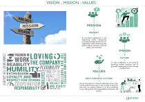
VISION - MISSION - VALUES To contribute significantly to the engineering world, continuously pursuing sustainable growth for our organization, while maintaining the perfect balance between resource quality and innovation. TBLOVINGOii reabilityTHE COMPANY?” LOYALTY andVI = REACT T0-“ RESPECT FOR OTHERS = FAILURES on To make a difference in the world by delivering reliable solutions and high-quality engineering services through a qualified team. PAST, PRESENT, FUTURE Our primary goal is to meet the objectives of our clients, both public and private, as well as those of everyone who joins our project,...
Open the catalog to page 2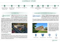
COMPANY STORY 1948 Impresa di Costruzioni Colombrita dei Fratelli Ing. Filippo e Paolo 1962 Impresa di Costruzioni Ing. Filippo e Paolo Colombrita s.n.c. 1984 2002 Colnisa Costruzioni Colnisa Costruzioni s.r.l. s.r.l. GIS DESIGN S.R.L. In 2002, driven by the initiative of the brothers Filippo and Fabio Colombrita, “GIS Design srl” was born, a company providing engineering services. GIS Design specializes in design and construction management using BIM methodology for building, infrastructure, and plant engineering projects. Additionally, the company offers support for participating in tenders...
Open the catalog to page 3
At GIS Design, our quality policy is oriented towards the continuous improvement of our organizational capabilities and the professional development of our staff and collaborators. We believe that our Quality Management System enables us to achieve established objectives, with the utmost respect for the requirements and requests of all involved parties (clients, employees, consultants, partners, etc.), applicable mandatory requirements, and the sustainability of our business decisions. ^ISO 45001:2023^ Certification of qualification for the execution of public works Occupational Health and Safety...
Open the catalog to page 4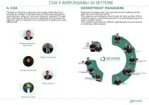
DEPARTMENT MANAGERS The Board of Directors represents the strategic leadership of our company. Its members bring experience and vision, ensuring that business decisions reflect our values and long-term objectives. Through their leadership, the Board promotes responsible and innovative management, which is essential to our commitment to quality and sustainable growth. Department managers play a key operational role, translating the Board’s vision into concrete actions. With expertise and dedication, they oversee the daily activities of their respective sectors, coordinating teamwork and optimizing...
Open the catalog to page 5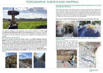
TOPOGRAPHIC SURVEYS AND MAPPING NETWORK INFRASTRUCTURE SURVEYS (WATER, SEWER, GAS, ETC.) AND SUBSURFACE MAPPING GIS Design specializes in conducting surveys of network infrastructures, including water, sewer, electricity, and gas, both geometrically and topographically. We utilize innovative instrumentation for manhole opening, network mapping, surveying, and GIS digitalization. Our equipment includes: Manhole opening tools with magnets and screws; GNSS instrumentation.; Compact laser scanners for 3D surveying of chambers; Robots for video inspection of conduits; Tablets with remote cloud connection...
Open the catalog to page 6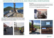
GEOGNOSTIC, GEOPHYSICAL AND STRUCTURAL INVESTIGATIONS Main activities: investigations, tests, on-site and laboratory checks aimed at designing and verifying seismic vulnerability; monitoring, geological and geotechnical characterization and structural diagnosis for the conservation of real estate assets; ground penetrating radar surveys to search for underground services; geological and geognostic investigations. The main customers include ANAS, RFI, Civil Protection, Navy, ADSP. GIS Design boasts a team of geologists, structural engineers, geotechnical engineers, and geophysicists capable of...
Open the catalog to page 7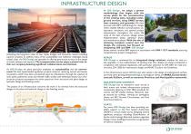
INFRASTRUCTURE DESIGN Unlocking the long-term value of new roads, bridges, and structures means providing superior projects to address many of the sustainability and resilience challenges facing today’s cities. At GIS Design, we specialize in offering paramount services in the design of roads, railways, and airports. The transportation sector plays a pivotal role within our company, boasting significant collaborations and clientele. At GIS Design, we place particular emphasis on sustainability and the environment. We have spearheaded significant projects aimed at restoring natural and human ecosystems,...
Open the catalog to page 8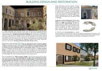
BUILDING DESIGN AND RESTORATION direct observation, and the creation of photographic documentation.This wealth of knowledge allows for a thorough understanding of the work and leads to the definition of the crack pattern, an important phase for the restoration project, in which all forms of alteration and degradation of the stone material are identified based on the Lexicon identified by the Normal 1/88 (Regulations for Stone Artefacts), now contained in UNI 11182:2006. Innovation is the beating heart of our company. As a support for building design, we have adopted the BIM methodology. The BIM...
Open the catalog to page 9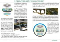
INTEGRATION BETWEEN GIS AND BIM Our corporate group is strongly characterized by innovative process and product aspects, making technological innovation and scientific research the true core business of our company. The expertise developed by the group in the GIS sector, combined with the meticulous pursuit of maximum customer satisfaction and the development of products of high technical quality, represent the strengths of the group. We are capable of directly performing the majority of the functions required within the scope of integrated management systems: topographic and environmental surveys,...
Open the catalog to page 10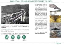
INSPECTION OF BRIDGES,VIADUCTS AND TUNNELS Our inspections gather valuable data, seamlessly integrated into a GIS project and enriched with additional information, including Web Map Service (WMS) such as road layouts, transportation systems, constraints, cadastre, 1:10,000 mapping, orthophotos, to obtain a comprehensive view of each investigated element. Within the GIS project, all structural surveys can be uploaded and georeferenced, easily accessible with just a click on the map. This enables us to create a tool capable of scheduling routine checks and regular maintenance, supporting decisions...
Open the catalog to page 11