- Catalogs
- Garmin International, Inc.
- aera 795/796
- Products
- Catalogs
- News & Trends
- Exhibitions
aera 795/796

aera 795/796
The Garmin aera 795/796 Quick Reference Guide provides essential operating instructions for the device's major features, including navigation, flight planning, and hazard avoidance. It is structured into sections covering various functionalities and settings, with a reminder to refer to the Pilot’s Guide for comprehensive procedures and warnings.
- Battery Installation: Insert the lithium-ion battery until it clicks.
- Charging: Connect to the aircraft's power outlet, ensuring the cable does not interfere with operations.
- GPS Receiver Status: Check signal strength via Main Menu > Tools > GPS Status.
- Display Orientation: Switch between Portrait and Landscape via Main Menu > Tools > Setup > Display or by pressing the Power Button.
- Touchscreen Operation: Select items by touching them; they turn blue momentarily.
- Scrolling and Panning: Drag to scroll or pan maps and documents.
- Zooming: Pinch to zoom out, spread fingers to zoom in.
- Dedicated Icons: Quick access to functions like returning to the previous screen or accessing the Main Menu.
This section covers flight data, HSI/Panel settings, vertical navigation, waypoints, and direct-to navigation features.
Instructions on creating, storing, activating, and deleting flight plans, as well as approaches.
Details on weather, terrain, and traffic information services, including SiriusXM Weather and Data Link Traffic.
Features such as flight log, track log, E6B calculator, aircraft profile, and weight & balance are covered.
Contains miscellaneous message advisories, airspace messages, data field options, alerts, and compliance information.
- Disconnect the external power cable when not in use for extended periods to prevent battery discharge.
- Refer to the Pilot’s Guide for comprehensive operating procedures and warnings.
- Direct-to Function: Allows direct navigation to a selected waypoint.
- Nearest Icons: Provides quick access to the nearest airports and other navigation aids.
- Page Buttons: User-configurable buttons for quick access to frequently used pages like Map, Weather, and Charts.
- Main Menu Icons: Access to various functions such as Map, Terrain, 3D Vision, and Weather.
- Access Main Menu, select Tools > Setup > Display > Choose Buttons.
- Select a new Page Button to replace an existing one.
- Save the configuration.
Access to weather products like NEXRAD, Satellite, Echo Tops, and more.
Access to setup icons, user waypoints, flight logs, VNAV, and other utilities.
Configuration options for display, sound, units, map settings, and more.
- Option Menus: Context-sensitive menu options available via a dedicated icon.
- Data Entry: Icons for entering alphanumeric data, including OK, BKSP, and Cancel.
- Map Range: 23 different map ranges available, with auto zoom functionality.
- Map Panning: Allows viewing and selecting locations outside the displayed range.
- Map Overlays: Weather, Topography, and Terrain overlays can be displayed or removed.
Instructions for pairing the GDL 39 device via Bluetooth.
To select an airport or runway by identifier, facility name, or city, navigate to the WPT Info tab from the Main Menu. Use the Waypoint Identifier Button to choose your search method and enter the desired data.
Access nearest information by touching NRST and selecting the desired icon (e.g., Airport, VOR, NDB).
View textual weather information via the WPT Info Icon or NRST > Airport WX.
Create user waypoints by selecting a point on the map, then using the Menu to create and name the waypoint.
Enter a waypoint as a direct-to destination using the Direct To Icon.
Flight plans can be created, stored, and activated. Use the Active FPL Icon to manage active plans or the FPL List for stored plans.
Stored flight plans can be reviewed and activated from the FPL List.
Stored flight plans can be deleted individually or all at once from the Main Menu.
The aera 795/796 provides monitoring for the final course segment of published approaches.
- Weather: The aera 796 supports multiple weather sources including XM and GDL FIS-B.
- Terrain: Terrain shading can be toggled on the Navigation Map.
- Traffic: Compatible with TIS-A and ADS-B/TIS-B traffic sources.
- Flight Log: Users can view, delete, and manage flight logs from the Tools menu.
- Track Log: Track logs can be shown/hidden, edited, and saved.
- E6B Calculator: Provides calculations for density altitude, true airspeed, and wind conditions.
- Calculating Winds Aloft: Users can calculate winds aloft using the E6B calculator.
- Aircraft Profile Management: Users can create, select, rename, and delete aircraft profiles.
- Weight & Balance Calculations: Steps for entering weights and arms to calculate moment, weight, and center of gravity.
Lists various system messages and troubleshooting steps.
Definitions for various data fields are provided.
Includes a software license agreement and a limited warranty covering defects for one year.
Contact details for Garmin Product Support in the USA and Europe are provided.
Includes disclaimers from AOPA, AC-U-KWIK, and Sirius XM, stating the information is provided "as is" without warranties.
Outlines terms of use, including subscription fees and limitations on liability.
The device complies with FCC and Industry Canada regulations.
Catalog excerpts
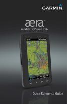
Quick Reference Guide
Open the catalog to page 1
FLIGHT PLANNING HAZARD AVOIDANCE
Open the catalog to page 3
Copyright © 2011 Garmin Ltd. or its subsidiaries. All rights reserved. This manual reflects the operation of System Software version 3.10 or later. Some differences in operation may be observed when comparing the information in this manual to earlier or later software versions. Garmin International, Inc., 1200 East 151st Street, Olathe, Kansas 66062, U.S.A. Tel: 913/397.8200 Fax: 913/397.8282 Garmin AT, Inc., 2345 Turner Road SE, Salem, OR 97302, U.S.A. Tel: 503/391.3411 Fax 503/364.2138 Garmin (Europe) Ltd, Liberty House, Bulls Copse Road, Hounsdown Business Park, Southampton, SO40 9RB, U.K....
Open the catalog to page 5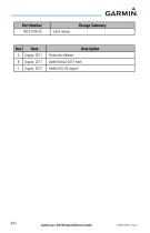
Change Summary Initial release Description Production Release Added Russia GOST mark Garmin aera 795/796 Quick Reference Guide
Open the catalog to page 6
Garmin aera 795/796 Quick Reference Guide
Open the catalog to page 7
Garmin aera 795/796 Quick Reference Guide
Open the catalog to page 8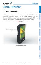
SECTION 1 OVERVIEW 1.1 UNIT OVERVIEW Flight Planning Power Button The purpose of this document is to provide a resource with which to find operating instructions on the major features of the aera 795/796 more easily. This Quick Reference Guide is not intended to be a comprehensive operating guide. Refer to the aera 795/796 Pilot’s Guide for complete operating procedures and warnings. Hazard Avoidance External Antenna Connector USB Connector Unit Overview (Left Side) Appendix Index Garmin aera 795/796 Quick Reference Guide
Open the catalog to page 9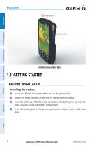
Power Button Hazard Avoidance Flight Planning Unit Overview (Right Side) BATTERY INSTALLATION Installing the battery: 1) Locate the lithium-ion battery that came in the product box. 2) Locate the metal contacts on the end of the lithium-ion battery. 3) Insert the battery so that the metal contacts on the battery line-up with the metal contacts inside the battery compartment. 4) Insert the battery into the battery compartment, and push until it clicks into place. Garmin aera 795/796 Quick Reference Guide
Open the catalog to page 10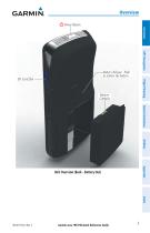
Overview Power Button Overview GPS Navigation Battery Release: Push to remove the battery Flight Planning Battery Contacts Hazard Avoidance Utilities Appendix Unit Overview (Back - Battery Out) Garmin aera 795/796 Quick Reference Guide
Open the catalog to page 11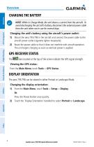
NOTE: While in Charge Mode, the unit draws a current from the aircraft. To avoid discharging the aircraft’s battery, disconnect the external power cable from the unit when not in use for several days. Flight Planning Charging the unit’s battery using the aircraft's power outlet: 1) Mount the aera 795/796 in the aircraft and connect the power cable to the aircraft power outlet (cigarette lighter receptacle). 2) Route the power cable so that it does not interfere with aircraft operation. The unit begins charging as soon as external power is applied. bars located at the top of the screen indicate...
Open the catalog to page 12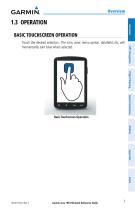
1.3 OPERATION BASIC TOUCHSCREEN OPERATION T ouch the desired selection. The icon, view, menu option, datafield, etc, will momentarily turn blue when selected. Flight Planning Hazard Avoidance Basic Touchscreen Operation Utilities Appendix Index Garmin aera 795/796 Quick Reference Guide
Open the catalog to page 13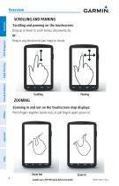
Hazard Avoidance Flight Planning Scrolling and panning on the touchscreen: D rag up or down to scroll menus, documents, etc. Or: D rag in any direction to pan maps or charts. Zooming in and out on the touchscreen map displays: P inch fingers together (zoom out), or pull fingers apart (zoom in). Garmin aera 795/796 Quick Reference Guide
Open the catalog to page 14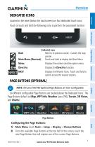
DEDICATED ICONS Located on the bezel (below the touchscreen) are four dedicated touch icons. Touch or touch and hold the following icons to perform the associated function: Returns to previous screen. Cancels the map pointer. Touch and hold to display the Main Menu. Displays the context sensitive option menu. Displays the Direct-to function. Displays the Nearest Icons. Touch and hold to quickly access the nearest airports. Hazard Avoidance Main Menu (Shortcut) Menu Direct-to NRST Flight Planning Dedicated Icons PAGE BUTTONS (OPTIONAL) NOTE: The aera 795/796 Optional Page Buttons are User Configurable....
Open the catalog to page 15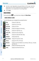
3) From the current Page Buttons along the bottom of the screen, touch the Page Button that will be replaced by the new page button. The current Page Button is now replaced by the new Page Button. 4) Touch Save. MAIN MENU Touch and hold the icon at any time to display the Main Menu. MAIN MENU ICONS Flight Planning Touch the following icons to display the associated function: Displays the Waypoint Information. Displays the Flight Plan List. Displays the Active Flight Plan. Displays the dedicated Traffic Page. Displays flight data. Displays the document viewer. Weather SiriusXM D isplays second-level...
Open the catalog to page 16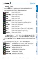
NEAREST ICONS icon at any time to access the second-level Nearest icons. Touch the following icons to display the associated function: Displays nearest airports. Airport WX isplays nearest airport weather. D VOR Displays nearest VORs. Displays nearest NDBs. Displays nearest Visual Reporting Point (VRP) (Atlantic). Displays nearest user waypoints. Displays nearest cities. Displays nearest ARTCCs (Air Route Traffic Control Centers). Displays nearest Flight Service Stations (FSS). Displays nearest airspace. Hazard Avoidance Flight Planning Intersection Displays nearest intersections. From the Main...
Open the catalog to page 17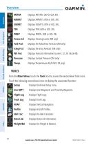
Displays Freezing Levels (XM only) Turb Fcst Displays the Turbulence Forecast (XM only) Icing Fcst Displays the Icing Forecast (XM only) Displays Forecast Information (current, 12, 24, 36, & 48). Displays Surface Pressure (XM only) Flight Planning Hazard Avoidance Displays Temperatures Aloft (GDL 39 only). TOOLS From the Main Menu, touch the Tools Icon to access the second-level Tools icons. Touch the following second-level icons to display the associated function: Setup Displays third-level Setup Icons. Displays Track Logs. Displays Vertical Navigation. Displays Aircraft Profiles. Data Link...
Open the catalog to page 18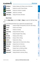
Overview Displays database and software version information. Displays the aircraft's Present Position. Displays the checklists if available. Displays GPS status information. Setup Icons Touch the following third-level icons to perform the associated function: Display Displays backlight intensity/timeout and color mode settings. D isplays sound settings. Displays unit settings. Displays date & time settings. Displays Navigation Map settings. Displays position settings. Displays interface settings. Displays alarm settings. Displays Special Use Airspace alarm settings. Data Link Displays Data Link...
Open the catalog to page 19Archived catalogs
 aera
aera6 Pages
 G500H
G500H92 Pages
 GPSMAP695/696
280 Pages
 VIRB
VIRB16 Pages