FIXAR 007 Catalogue

FIXAR 007 Catalogue
The FIXAR 007 is a versatile, fully autonomous fixed-wing VTOL drone designed for commercial and industrial applications. It supports various payloads such as RGB and multispectral cameras, LiDAR, and parcel delivery modules. With a payload capacity of up to 2 kg and a range of up to 60 km, it ensures efficient mission completion.
The drone offers up to 35% cost savings compared to other market solutions, with a flight time of up to 60 minutes. It features high maneuverability, weather resistance, and includes a swappable payload module, easy operation, and comprehensive support and training.
FIXAR 007 provides stress-free autonomous flight, including take-off and landing over unstructured terrain. It ensures mission data security and includes a BlackBox module for data logging.
Equipped with RGB camera payloads, the drone is ideal for terrain inspections and surveying, offering high accuracy and user-friendliness. It supports applications such as cadastral surveying, mining, and urban planning, integrating with popular photogrammetry software for high-quality imaging.
FIXAR 007 facilitates fast and precise aerial laser scanning, especially in remote and forested areas. It integrates with advanced LiDAR systems like YellowScan Mapper+OEM, providing high precision for forestry, agriculture, and construction applications.
The drone supports multispectral sensors for agricultural and environmental analysis, integrating with the MicaSense RedEdge-P camera for detailed vegetation mapping and analysis.
FIXAR 007 addresses delivery challenges by reducing transport time and costs. It supports multi-point delivery routes and features an automatic parcel release system, suitable for medical and document deliveries.
The drone extends observation range for security monitoring, infrastructure inspection, and search and rescue operations, offering fast response capabilities and cost-effective solutions with swappable payload modules.
The document also details high-tech gimbal and camera systems for security and surveillance, including monitoring of oil & gas sites, power lines, pipelines, railways, traffic management, and insurance claim inspections.
- Tarot Peeper HD 10X Optical Zoom: A 3-axis gimbal with a 10X optical zoom, featuring a 1/3 color CMOS4 image sensor with approximately 4 million effective pixels (2688 x 1520). Total weight is 365g.
- Sky Eye-I 1080P 10X Zoom: Designed for 10X zoom, this gimbal records 1080p 30 fps video to an onboard TF card. Total weight is 430g.
- Eagle Eye-10IE 10X EO/IR Dual Sensor: A 3-axis high stabilized thermal camera with EO and IR sensors, providing 1080P 60FPS full HD video streaming and up to 120X zoom capability. Total weight is 879g.
- Advanced thermal tracking technology in the Eagle Eye-10IE ensures objects are not lost during monitoring.
- All systems are designed to provide stable and effective aerial surveillance over large areas.
For quotes, online meetings, training, or demonstrations, contact FIXAR-AERO LLC at [email protected] or visit their website at www.fixar.pro. Address: Skandu 7, Riga, Latvia, EU.
Catalog excerpts

FIXAR 007 PRODUCT CATALOGUE COST-EFFECTIVE DRONE SOLUTION FOR EACH JOB FIXAR is a trademark of FIXAR-AERO LLC, registered in Latvia. All intellectual property rights are owned by FIXAR-AERO LLC. Patents pending. Copyright ©2022, FIXAR-AERO, LLC. All rights reserved.
Open the catalog to page 1
MEET FIXAR 007 The FIXAR 007 is a fully autonomous, fixed-wing VTOL (vertical take-off and landing) drone designed to meet the needs of a wide variety of commercial and industrial applications. The versatile FIXAR 007 model offers a broad array of payloads such as high-quality RGB, multispectral camera, LiDAR, customized parcel delivery module, and more based on real tasks. The high payload capacity of up to 2 kg (4.4 lbs) in combination with high endurance of up to 60 km (37.2 mi) allows it to accomplish mission objectives faster and costefficiently. An easy-to-use proprietary xGroundControl...
Open the catalog to page 2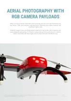
AERIAL PHOTOGRAPHY WITH RGB CAMERA PAYLOADS When it comes to terrain inspections and surveying, accuracy and user-friendliness are key factors. Field work requires long man-hours, extending any project timeline and resulting in higher costs. FIXAR 007 systems have a working payload capacity of 2 kg (4.4 lbs), with a spacious and easily adaptable payload bay. As a result it is easy to set up a line-up of sensors in order to capture more data with fewer flights and in a more time and cost efficient way. FIXAR is a trademark of FIXAR-AERO LLC, registered in Latvia. All intellectual property rights...
Open the catalog to page 3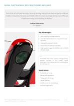
AERIAL PHOTOGR APHY WITH RGB C AMER A PAYLOADS “ “First of all this UAV fixes the major issues of working with both the fixed-wing and multirotor models. It is quickly and easily assembled within 2 minutes by simply taking it out of the box, snapping on wings and installing the battery.” Philippe Saint-Martin CEO, VideoDrone Key Advantages: Vast mapping coverage capacity Accurate dataset down to 1 cm/px (0.4 in/px) with PPK Swappable payload module Broad array of payloads available High quality images at 50-5000 m (65 -14763 ft) altitude range i Compatible with most popular photogrammetry software...
Open the catalog to page 4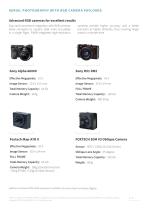
AERIAL PHOTOGR APHY WITH RGB C AMER A PAYLOADS Advanced RGB cameras for excellent results Easy and convenient integration with RGB cameras allow surveyors to capture data more accurately in a single flight. FIXAR integrated high-resolution cameras provide higher accuracy and a better precision at higher altitudes, thus covering larger areas in a shorter time. Total Memory Capacity: 64 Gb FULL FRAME Total Memory Capacity: 128 Gb Camera Weight: 480-507g FOXTECH 3DM V3 Oblique Camera Sensor: APS-C CMOS (23.5X15.6mm) Oblique Lens Angle: 45 degree FULL FRAME Total Memory Capacity: 320 Gb Total Memory...
Open the catalog to page 5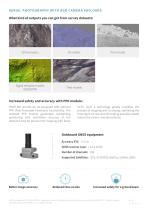
AERIAL PHOTOGR APHY WITH RGB C AMER A PAYLOADS What kind of outputs you can get from survey datasets: Digital elevation models (DSM/DTM) Point clouds Tiled models Increased safety and accuracy with PPK module: FIXAR 007 aircraft can be equipped with optional PPK (Post-Processed Kinematic) functionality. The onboard PPK module guarantees outstanding positioning with centimeter accuracy of the obtained data for precise UAV mapping with fewer GCPs. Such a technology greatly simplifies the process of mapping and surveying, optimizing the time spent on-site and eliminating possible related risks to...
Open the catalog to page 6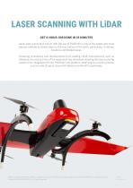
LASER SCANNING WITH LiDAR GET 6-HOUR JOB DONE IN 35 MINUTES Aerial laser scanning of terrain with the use of FIXAR 007 is one of the fastest and most precise methods to obtain data on the true surface of the earth, particularly, in remote locations and forested areas. Following innovations and developments from leading LiDAR manufacturers such as Velodyne, the cost and size of the equipment has decreased allowing the laser scanning system to be integrated with the FIXAR 007 UAV platform, obtaining as a result a precise and accurate 3D point cloud with reference to the GPS coordinates. FIXAR is...
Open the catalog to page 7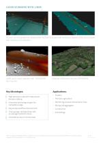
L ASER SC ANNING WITH LiDAR 3D point cloud of powerlines collected with FIXAR 007 equipped with YellowScan Mapper+OEM and processed with YellowScan CloudStation. LIDAR point cloud captured with TOPODRONE laser scanner Key Advantages: High precision outputs for data-driven decision making Colorized LIDAR point cloud by TOPODRONE Applications: • Forestry • Precision agriculture Innovative technology to gain the competitive edge • Monitoring of power transmission lines Day-to-day workflow improvement Time savings: 10x faster than with an average multirotor drone Unlocked access to remote areas FIXAR...
Open the catalog to page 8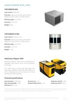
L ASER SC ANNING WITH LiDAR TOPODRONE AVIA Laser sensor: LIVOX AVIA Precision: High-precision IMU with 0.08/0.03 degrees accuracy and L1/L2 GNSS receiver Working range: up to 150 m Accuracy: 3-5 cm XYZ Weight: 0.8 kg TOPODRONE ULTRA Laser sensor: Velodyne Ultra Precision: High-precision IMU with 0.08/0.03 degrees accuracy and L1/L2 GNSS receiver Working range: up to 150 m Accuracy: 3-5 cm XYZ Weight: 1.1 kg YellowScan Mapper+OEM YellowScan Mapper+ OEM is the next generation of integrated lidar solution with Livox and Applanix technology. This LiDAR System is particularly lightweight with long...
Open the catalog to page 9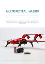
MULTISPECTRAL IMAGING Thousands of farmers, agricultural professionals, environmental researchers and forestry experts worldwide have already experienced the advantages of drones integrated with multispectral sensors. FIXAR integrated UAV platforms simplify the work, increase efficiency, and protect assets, people, and the environment. Professional FIXAR 007 drone with multispectral camera is a sustainable and cost-effective management solution supporting clever data-driven decision-making. FIXAR is a trademark of FIXAR-AERO LLC, registered in Latvia. All intellectual property rights are owned...
Open the catalog to page 10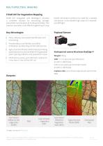
MULTISPECTR AL IMAGING FIXAR 007 for Vegetation Mapping FIXAR 007 integrated with RedEdge-P provides a complete solution for processing, storage, presentation and analysis of multispectral data. This solution provides a cost-effective gathering of crop health information without the need for a satellite connection or the related high costs of a mannedaircraft flight. Payload Sensor: Pests, diseases and weeds identification and monitoring Provide data on soil fertility and refine fertilization by detecting nutrient deficiencies Agricultural and forestry field analysis providing a precise plant...
Open the catalog to page 11All FIXAR catalogs and technical brochures
 FIXAR 025 Brouchure
2 Pages