
- Catalogs
- EOS Technologie
- Strix 400

Strix 400

Strix 400
- Endurance: 7 to 10 hours depending on power source.
- Video Range: 80 km (HD), 150 km (640p).
- Wingspan: 4.25 m (13.95 ft).
- Length: 1.97 m (3.28 ft).
- Maximum Take-off Weight: 8.5 Kg (22 lbs).
- Speed: Cruising speed of 50-90 km/h, with a minimum of 22 km/h and a maximum of 120 km/h.
- Altitude: Up to 5,000 m (16,000 ft).
- Temperature Range: -10°C to 55°C.
- Data Encryption: AES256.
- Noise Perception: 600 m with motor on, 300 m in stealth mode.
- Full HD TV, IR, and Laser Range Finder.
- 360° gyro-stabilized gimbal with a weight of 640 gr.
- Camera resolution of 1980p x 1080p with continuous zoom up to X80.
- IR resolution of 1280p x 720p with X8 digital zoom.
- Minimum training: 2 weeks for operators, 3 weeks for instructors.
- Features include programmed waypoints, racetrack mode, automatic take-off and landing, and return to home.
- 10-minute assembly by a single operator.
- Video data range up to 150 km.
- Includes two rugged laptops with MIL-STD-810H, IP65, and MIL-STD-461G standards.
- Data encryption with AES 256.
- Compact suitcase dimensions: 86 x 56 x 33 cm, weighing 28 kg.
- Features include terrain elevation and obstacle management, automatic overlap calculations, and advanced geofencing.
- Flight monitoring software ensures safety with features like ground proximity warning and powerful alarm systems.
- Allows for easy data integrity checks and geotagging with centimetric accuracy.
- Compatible with all photogrammetric suites on the market.
Catalog excerpts

STRIX 400 Surveillance UAS - 7h to 10h endurance - 150km video range
Open the catalog to page 1
DATASHEET Wingspan Maximum Take-off weight Endurance (Li-Ion + Solar) Cruising speed Video range Data encryption Noise perception 600 m motor on / 300m motor of (stealth mode) Electro-optic sensors TV Full HD, IR, Laser Range Finder
Open the catalog to page 2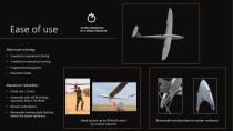
10 MIN ASSEMBLING BY A SINGLE OPERATOR Minimum training: • 2 weeks for operators training 3 weeks for instructors training Programmed waypoints Racetrack mode Maximum reliability: • Automatic take-off & landing , automatic Return To Home Sensors redundancy Removable landing skate (ballistic Kevlar) for better resilience Hand launch up to 50 Km/h wind (no catapult required) Removable landing skate for bett
Open the catalog to page 3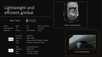
Lightweight and efficient gimbal Laser range finder : Control interface : Camera lens : Continuous, X80 (x40 Optical + x2 digital) 60° WFOV -1,5° NFOV -0,75° DFOV 360° giro stabilized gimbal Full retractabl
Open the catalog to page 4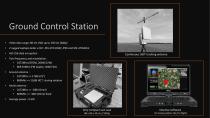
Ground Control Station • Video data range: 80 km (HD) up to 150 km (640p) Twin frequency and modulation : • 2472Mhz (OFDM, 20M0 D2W) • 869.55Mhz (FM duplex, 50K0 F2D) Ground antenna : • 2472Mhz => 17dBi (23°) • 869Mhz => 12dBi (41°) during rotation Aerial antenna : • 2472Mhz => 3dBi (Omni) • 869Mhz => 3dBi (Omni) fixed Continuous 360° tracking antenna Very compact suit case 86 x 56 x 33 cm // 28 kg Intuitive software
Open the catalog to page 5
UAS born to freight Low logistical footprint: • • Only 1 freight case 1 Strix 400 + 3 Batteries Only 2 operators to carry the case IP mil-std 810G UAV (42kg) ULTRA-RESISTANT MATERIALS Fit into a standard car trunk 60 cm Backpack transport possi
Open the catalog to page 6
Autopilot UI Flight planning at fingertips • Make sure your flights are safe with terrain elevation and obstacle management features. It also includes our patent-pending tool which greatly optimizes the time required to follow curved linear networks Continuous 360° tracking antenna Planning features: • Display World imagery / World elevation map View obstacles (Power lines and Wind turbines) Plan using powerful large area and linear networks mapping tools Automatic overlap calculations Use our patent-pending linear networks following tool Export & Import KML/KMZ files Display flight path and...
Open the catalog to page 7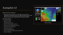
Autopilot UI Flight monitoring at fingertips • Following aeronautic standards, our in-house flight monitoring software (“Aerostation”) automatically monitors all the flight parameters and ensures flight safety at all times. Once you have planned your mission with Aeroplanner, Aerostation will allow you to simulate, fly and even replay your missions. Continuous 360° tracking antenna Monitoring features: • Simulate your flights Replay your missions Ground proximity warning Automatic self-test & take-off checklist Interrupt and restart flight plans at any time Powerful alarm & warning system Display...
Open the catalog to page 8
Autopilot UI Easy data export • In just a few clicks, “Aerogeo” will allow you to check the integrity of your data and export geotagged images with centimetric accuracy to subsequent photogrammetric post-processing software. Continuous 360° tracking antenna Export features: • Check data integrity Geotag your pictures Obtain centimetric accuracy with PPK GPS Compatible with all photogrammetric suites on the marke
Open the catalog to page 9All EOS Technologie catalogs and technical brochures
 Endurance 1000
15 Pages