- Catalogs
- EARTH NETWORKS
- THE ULTIMATE WEB-BASED COLLABORATIVE WEATHER MONITORING VISUALIZATION AND ALERTING MAPPING TOOL
THE ULTIMATE WEB-BASED COLLABORATIVE WEATHER MONITORING VISUALIZATION AND ALERTING MAPPING TOOL
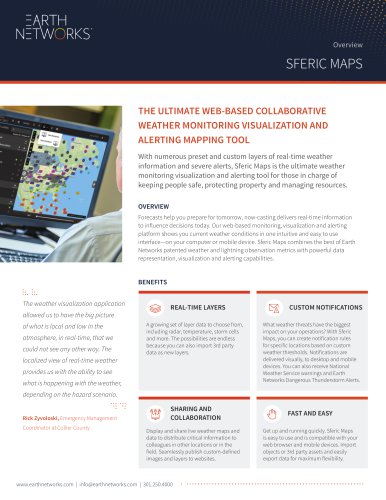
THE ULTIMATE WEB-BASED COLLABORATIVE WEATHER MONITORING VISUALIZATION AND ALERTING MAPPING TOOL
Sferic Maps is a web-based weather monitoring, visualization, and alerting tool designed to provide real-time weather information and severe alerts. It is particularly useful for emergency managers, airport crews, stadium managers, and other operations centers responsible for safety and resource management.
Benefits
The platform allows users to display and share live weather maps and data, facilitating collaboration and decision-making during severe weather events. It supports the import of third-party data and offers a wide range of layer data, including radar, temperature, and storm cells.
Features
- Real-Time Layers: Offers numerous preset and custom layers of weather information.
- Custom Notifications: Users can create notification rules based on custom weather thresholds for specific locations.
- Fast and Easy Setup: Compatible with web browsers and mobile devices, allowing for quick deployment and use.
Advantages
- Enables intelligent weather-related decisions.
- Facilitates collaboration with stakeholders during severe weather events.
- Prioritizes safety and security by increasing response times with advanced severe weather warnings.
Technology
- World’s Largest Weather Network: Utilizes a network of over 12,000 professional-grade weather stations.
- EN Total Lightning Network: Provides fast severe weather warnings through total lightning detection, with over 1,200 sensors in 40+ countries.
- Dangerous Thunderstorm Alerts: Offers advanced alerts through in-cloud lightning detection, helping minimize severe weather risks.
Contact Information
For more than 20 years, Earth Networks has been providing advanced environmental intelligence through its comprehensive weather observation and lightning detection networks. For inquiries, contact (301) 250-4000 or [email protected].
Catalog excerpts
THE ULTIMATE WEB-BASED COLLABORATIVE WEATHER MONITORING VISUALIZATION AND ALERTING MAPPING TOOL With numerous preset and custom layers of real-time weather information and severe alerts, Sferic Maps is the ultimate weather monitoring visualization and alerting tool for those in charge of keeping people safe, protecting property and managing resources. OVERVIEW Forecasts help you prepare for tomorrow, now-casting delivers real-time information to influence decisions today. Our web-based monitoring, visualization and alerting platform shows you current weather conditions in one intuitive and easy to use interface—on your computer or mobile device. Sferic Maps combines the best of Earth Networks patented weather and lightning observation metrics with powerful data representation, visualization and alerting capabilities. The weather visualization application allowed us to have the big picture of what is local and low in the atmosphere, in real-time, that we could not see any other way. The localized view of real-time weather provides us with the ability to see what is happening with the weather, depending on the hazard scenario. Rick Zyvoloski, Emergency Management Coordinator at Collier County A growing set of layer data to choose from, including radar, temperature, storm cells and more. The possibilities are endless because you can also import 3rd party data as new layers. aaaSHARING AND MV! M COLLABORATION Display and share live weather maps and data to distribute critical information to colleagues in other locations or in the field. Seamlessly publish custom-defined images and layers to websites. What weather threats have the biggest impact on your operations? With Sferic Maps, you can create notification rules for specific locations based on custom weather thresholds. Notifications are delivered visually, to desktop and mobile devices. You can also receive National Weather Service warnings and Earth Networks Dangerous Thunderstorm Alerts. FAST AND EASY Get up and running quickly. Sferic Maps is easy to use and is compatible with your web browser and mobile devices. Import objects or 3rd party assets and easily export data for maximum flexibility.
Open the catalog to page 1
SFERIC MAPS ADVANTAGES • Make intelligent weather-related decisions • Collaborate with stake-holders during severe weather events • Prioritize safety and security INCREASE RESPONSE TIMES WITH THE INDUSTRY’S MOST ADVANCED SEVERE WEATHER WARNING Sferic Maps provides emergency managers, airport crews, stadium managers, event staff, facility managers and operations centers with web-based access to our best weather detection technologies. Only Sferic Maps shows live radar together with lightning flashes detected by the Earth Networks Total Lightning Network®—the first to comprehensively capture both...
Open the catalog to page 2All EARTH NETWORKS catalogs and technical brochures
 LightningSafety_Poster
1 Page
 PREDICT AND PREVENT OUTAGES
2 Pages
 OBSERVE. PREPARE. PROTECT
2 Pages
 Networks Calibration System
2 Pages


