- Catalogs
- Dronelab unmanned systems srl
- Skyqube V.2
Skyqube V.2
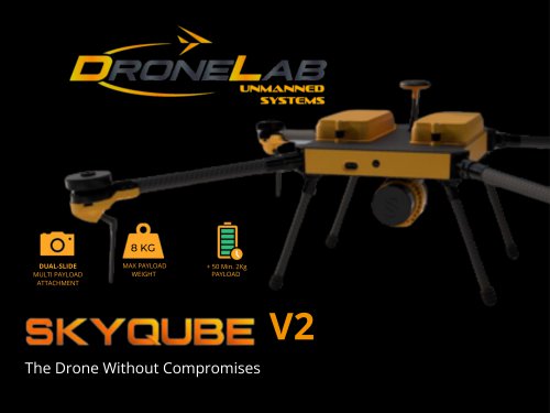
Skyqube V.2
Catalog excerpts
8 KG DUAL-SLIDE MULTI PAYLOAD ATTACHMENT V2 The Drone Without Compromises
Open the catalog to page 1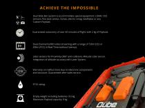
ACHIEVE THE IMPOSSIBLE Dual Slide Bar system to accommodate special equipment; LiDAR, CO2 sensors, fine dust sensor, fumes, electro smog, GeoRadar or any Custom Payload. Guaranteed autonomy of over 50 minutes of flight, with 2 kg of Payload. Dual channel FullHD video streaming with a range of 12Km (CE) or 20Km (FCC) in Real-Time (without latency). Lidar sensors for Proximity (360° anti-collision). Altitude Lidar sensor. Integration of altitude accuracy with Laser System. Warranty on malfunctions due to electronic components and structure. Guaranteed after-sales service. Empty weight including...
Open the catalog to page 3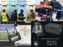
VERSATILE AND SUITABLE FOR ANY OPERATION STURDY AND EASY TO CARRY
Open the catalog to page 4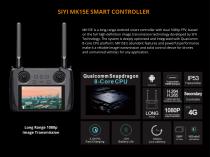
SIYI MK15E SMART CONTROLLER MK15E is a long-range Android smart controller with dual 1080p FPV, based on the full high-definition image transmission technology developed by SIYI Technology. The system is deeply optimized and integrated with Qualcomm 8-core CPU platform. MK15E's abundant features and powerful performance make it a reliable image transmission and solid control device for drones and unmanned vehicles for any application. Long Range 1080p Image Transmission
Open the catalog to page 5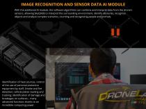
IMAGE RECOGNITION AND SENSOR DATA AI MODULE With the additional AI module, the software algorithms can combine and interpret data from the drone's sensors, allowing SkyQUBE to interpret the surrounding environment, identify obstacles, recognize objects and analyze complex scenarios, counting and recognizing people and animals. Identification of heat sources, control of the use of personal protective equipment by staff. Smoke and fire detection; vehicle plates reading and tracking; identification of damage and breakages on surfaces... many advanced functions thanks to an incredible computing power....
Open the catalog to page 6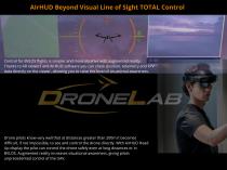
AIrHUD Beyond Visual Line of Sight TOTAL Control Control for BVLOS flights is simpler and more intuitive with augmented reality. Thanks to AR viewers and AirHUD software you can check position, telemetry and FPV data directly on the viewer, allowing you to raise the level of situational awareness. Drone pilots know very well that at distances greater than 200m it becomes difficult, if not impossible, to see and control the drone directly. With AirHUD Head Up display the pilot can control the drone safely even at long distances or in BVLOS. Augmented reality increases situational awareness, giving...
Open the catalog to page 7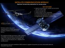
SATELLITE COMMUNICATION MODULE Optional Connectivity solutionfor for remote areas Hybrid communications: satellite and terrestrial (LTE, Wi- Fi, BT, LoRa) Iridium Certus® 100 Iridium Certus™ 9770 -Transceiver IP connectivity Cloud infrastructure and user portal Accurate tracking (GNSS) API (Application Programming Interface) for 3rd party apps Perfectly matches the service requirements for IoT/M2M applications, providing a flexible connectivity at low latency. The engineered design guarantees a high availability and reliable communication channel through the usage of the Iridium® satellite constellation...
Open the catalog to page 8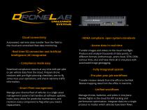
- Cloud connectivity Automated, real-time data transfer from the field to the cloud and centralized fleet data monitoring. - Real time 5G connection and Artificial Intelligence (AI) integration - Compliance made easy Download compliance reports at any time with per pilot or per vehicle data from the cloud. Prepare drone missions with pre-flight planning checklists, see no-fly zones near your operations, and check real-time traffic information. - Smart Fleet management Manage your diverse fleet of vehicles in a single asset management system that handles all software updates, tracks every drone...
Open the catalog to page 9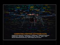
COMPATIBLE PARTNER SOFTWARE SUITE PangeaCloud, SkyBrowse - PIX4Dcapture - PIX4Dinspect - PIX4Dcloud PIX4Dreact PIX4Dsurvey – DroneSense - DroneLogbook Survae - Solex CC – UGCS – Litchi Mission PlanneQrGroundControl - Drone Deploy and a lot mo
Open the catalog to page 10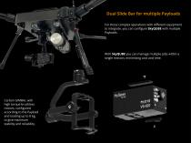
Dual Slide Bar for multiple Payloads For those complex operations with different equipment to integrate, you can configure SkyQUBE with multiple Payloads. With SkyQUBE you can manage multiple jobs within a single mission, minimizing cost and time. Carbon GIMBAL with high torque brushless motors, configured according to the Payload and loading up to 8 kg, to give maximum stability and reliability.
Open the catalog to page 11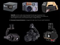
SkyQUBE can host a wide variety of payloads for each type of operation. From photogrammetry to more complex functions, such as the integration of a robotic arm, electromagnetic sensors, environmental sensors, or freight transport. Ask DroneLab Unmanned Systems to integrate the right sensor for your specific operations.
Open the catalog to page 12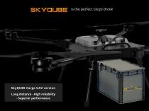
is the perfect Cargo Drone SkyQUBE Cargo UAV version Long distance - High reliability - Superior performance
Open the catalog to page 13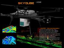
SkyQUBE - Lidar scanning system Compact and lightweight Lidar, nextgeneration laser scanner, GNSS and IMU positioning and altitude determination system, storage unit. It can acquire real-time point cloud data and image information. It is widely used in acquiring 3D spatial information in industrial topography, power plants, electricity, forestry, agriculture, land use planning.
Open the catalog to page 14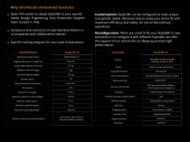
Why DroneLab Unmanned Systems: Open PX4 system to adapt SkyQUBE to your specific needs. Design, Engineering, Test, Production, Support Team located in Italy. Assistance and resolution of operational problems in a transparent and collaborative manner. Specific training program for your type of operations. PERFORMANCE Dimensions when closed Diagonal dimensions in flight line Empty weight (without batteries) Maximum take-off weight Maximum Payload weight Remote control Data transmission frequencies Maximum speed in horizontal flight Customization: SkyQUBE can be configured to meet unique and specific...
Open the catalog to page 15
DroneLab Unmanned Systems is a DroneLab brand www.dronelab.it Headquarters and production: Via Tirso 12, 08048 Tortolì (NU) Tel. 0782 209401 [email protected] Follow us on Linkedin Facebook
Open the catalog to page 16