
Catalog excerpts

Pix4Dmapper The leading photogrammetry and drone mapping software Desktop & cloud
Open the catalog to page 1
Versatile Flexible workflows Capture your images with any camera or drone, process them locally or on the cloud, and selectively share any part of the project. Powering multiple applications & industries A broad variety of tools to power applications in multiple industries, from surveying & mapping, construction, agriculture, mining & aggregates, public safety, oil & gas, power & utilities, to education & research and more. Use the software in your language. Pix4Dmapper is available on desktop in English, Japanese, German, Spanish, French, Chinese, Italian, Russian and Korean. Count on our...
Open the catalog to page 2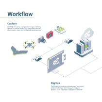
Workflow Capture Get RGB, thermal or multispectral images with any camera. Automate flights and image-data transfer when using a drone and the free Pix4Dcapture app. Digitize Pix4Dmapper transforms your images into digital models and maps. Seamlessly process your projects using our cloud or your local computer.
Open the catalog to page 4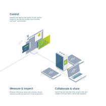
Control Assess and improve the quality of your project thanks to the detailed quality report and the rayCloud™ environment. Measure & inspect Collaborate & share Measure distances, areas and volumes, extract elevation profile and perform virtual inspections. Selectively and securely share project data and insights with your team, clients and suppliers.
Open the catalog to page 5
The power of understanding photogrammetry A unique environment connecting your original images to each point of the 3D reconstruction to visually verify and improve the accuracy of your project. Create objects and video animations, measure distances and surfaces. Edit your point clouds, add ground control points and manual tie points, define processing areas and more.
Open the catalog to page 7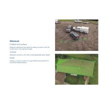
Measure Polyline and surface Measure distances and areas by setting vertices in the 3D model and in the original images. Volume Measure volumes in 3D with a fully-adjustable base height. Scale Assign a custom scale to non-georeferenced projects for accurate measurements.
Open the catalog to page 9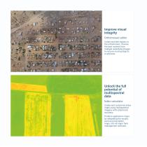
Improve visual integrity Orthomosaic editor Create and edit regions in the orthomosaic. Choose the best content from multiple underlying images to remove moving objects or artifacts. Unlock the full potential of multispectral data Index calculator Create and customize index maps using multispectral imagery with radiometric accuracy. Produce application maps by integrating the results, such as prescription maps, into all major farm management software.
Open the catalog to page 10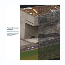
Flatten & smooth surfaces DSM and mesh editing Create surfaces to improve planarity or fill holes in critical areas.
Open the catalog to page 11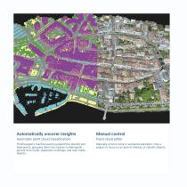
Automatically uncover insights Manual control Automatic point cloud classification Point cloud editor Pix4Dmapper’s machine-learning algorithms identify and label points, grouping them into classes to distinguish ground from roads, vegetation, buildings, and man-made objects. Manually remove noise or unwanted elements, crop a project to focus on an area of interest, or classify objects.
Open the catalog to page 12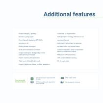
Additional features · Project merging / splitting · Detailed quality report · Orthoplane for creating orthomosaic of · Error ellipsoid displaying MTP/GCPs accuracy in 3D any plane/facade · Radiometric adjustment to generate · Rolling shutter correction accurate index and thermal maps · Scale and orientation constraint · Image masking for disregarding invalid pixels among all images · Custom indices for raster computation based on reflectance values · Multi-core CPU processing · Object creation and digitization · GPU-accelerated processing · Tiled Level-of-Detail (LoD) mesh · Import LIDAR...
Open the catalog to page 13
Expand your processing capabilities with Pix4D Cloud Process more projects, faster by taking full advantage of Pix4D Cloud processing resources. Continue using your local machine with no interruptions. Highlight findings Leverage the link between the 3D reconstruction and your original 2D images with the virtual inspector. Identify a point of interest in the 3D view and highlight critical elements in the original images, add descriptions or even attach external URLs. Annotate & export Pinpoint objects, measure distances, surfaces, volumes and elevation profiles. Export q uantitative,...
Open the catalog to page 15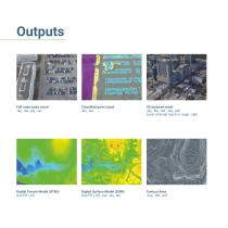
Full-color point cloud .las, .laz, .ply, .xyz Classified point cloud .las, .laz 3D textured mesh .ply, .fbx, .dxf, .obj, .pdf Level-of-detail mesh in .osgb, .slpk Digital Terrain Model (DTM)/ GeoTiff (.tif) Digital Surface Model (DSM) GeoTiff (.tif), .xyz, .las, .laz
Open the catalog to page 16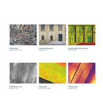
Facade orthomosaic GeoTiff (.tif) Facade digital surface model GeoTiff (.tif) Reflectance maps GeoTiff (.tif) Index maps GeoTiff (.tif), .shp Thermal maps GeoTiff (.tif)
Open the catalog to page 17
Teach and learn with Pix4Dmapper Teach with Pix4Dmapper Educational licenses Teach, learn and research the future of photogrammetry and mapping with Pix4Dmapper educational licenses tailored to schools and universities. pix4d.com/education Continous learning for mapping professionals Training & certification Strengthen your professional knowledge and skills with practical training. Choose from self-paced, instructor-led or custom training. Training is available online, onsite, and in multiple languages. pix4d.com/training
Open the catalog to page 18
Multi-licenses Empower your organization with multiple licenses of your preferred Pix4D solutions, with a smooth implementation and impactful enterprise-wide deployment. Pix4Dengine Your customized workflow. Your competitive advantage. Leverage 3D mapping in your automatic workflow or customized platform with Pix4Dengine: a set of APIs running on your infrastructure or in the cloud. Enterprise services Bring your ideas to life through our consulting and integration services, enterprise training and enterprise support.
Open the catalog to page 19All Draganfly Drones catalogs and technical brochures
-
Infield assessment
4 Pages
-
Mapping for Digital Agriculture
12 Pages


