
- Catalogs
- The DiSTI Corporation
- GL Studio Map Toolkit

GL Studio Map Toolkit

GL Studio Map Toolkit
The DiSTI Map Toolkit plug-in for GL Studio enables developers to create real-time 2-D moving map displays for desktop applications. It supports multiple map formats and symbology, allowing for the integration of various geo-referenced map imagery formats and user-defined symbols into a single map view.
Supported Map Data Formats
- DTED
- GeoTIFF
- CADRG
- DNC
- AIF (JPEG, PNG, TIFF, etc.)
- GL Studio Objects
Key Features
- Out-of-the-box or user-defined symbology
- Seamless addition of paths and waypoints
- Pre-caching of map data
- Dynamic paging of map imagery
- Simple integration into GL Studio projects
- Hardware-supported map rendering
- Pan, rotate, and zoom capabilities
- Auto-resolution based on altitude
Symbology
The toolkit includes 40 standard aviation symbols and supports MILSTD 2525 B symbology with various affiliations, echelons, and unit symbols. It allows for easy overlay of user-defined symbology created from GL Studio objects.
Arbitrary Image Format
This feature allows the insertion of geo-referenced map imagery layers from any standard image file format supported by GL Studio, using an XML schema to define these layers.
Elevation Data
- 2-D Terrain map with runtime controllable shading
- Up to 16 elevation bands with configurable colors
- Threat rings with line-of-sight shading
- Configurable contour lines
Control Features
- Data Visibility
- Color Control
- Map Orientation
- Overlay Visibility
- Layer Control Visibility
- Symbology Control
- Zoom Control
Conclusion
The DiSTI Map Toolkit provides a comprehensive solution for developing high-quality 2-D mapping applications, offering flexibility and extensive features for integrating diverse data sources into a cohesive display.
Catalog excerpts

ST DiSTI MapToolkit "N The DiSTI Map Toolkit plug-in for GL Studio allows developers to create real-time 2-D moving map displays for desktop-based applications. J
Open the catalog to page 1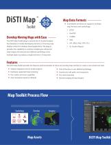
Develop Moving Maps with Ease- The DiSTI Map Toolkit plug-in extends the GL Studio Designer functionality to include developing real-time 2-D moving map display content for desktop-based applications. The plug-in provides the capability to combine multiple geo-referenced map imagery formats and user-defined symbology across multiple layers to produce a single real-time 2-D map view. Map Data Formats- » Extendable architecture supports multiple map formats and symbology: • DTED • GeoTIFF • CADRG • DNC • AIF (JPEG, PNG, TIFF, ETC.) • GL Studio Objects The DiSTI Map Toolkit provides the features...
Open the catalog to page 2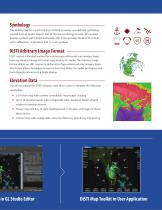
Symbology This toolkit provides a quick and easy method to overlay user-defined symbology, created from GL Studio objects. Out-of-the-box symbology includes 40 standard aviation symbols with full HSI and quarter HSI. It also includes the MILSTD 2525 B with 4 affiliations, 12 echelons, and 113 unit symbols. DiSTI Arbitrary Image Format DiSTI created a standard method for inserting geo-referenced map imagery layers from any standard image file format supported by GL Studio. The Arbitrary Image Format utilizes an XML schema to define sets of geo-referenced map imagery layers. This feature allows...
Open the catalog to page 3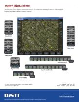
The DiSTI Map Toolkit offers the flexibility to combine the components necessary to produce high quality 2-D mapping applications. Below is a sample anatomy. For more information on all of our products and services, please visit www.disti.com DiSTI and GL Studio are registered trademarks of The DiSTI Corporation. Copyright © 2014 DiSTI all rights reserved. 11301 Corporate Blvd., Suite 100 Orlando, FL 32817 | 407-206-3390
Open the catalog to page 4All The DiSTI Corporation catalogs and technical brochures
 Approach Plate Toolkit
1 Page
 GL Studio for Automotive
4 Pages
 VE Studio®
4 Pages


