- Catalogs
- DELAIR-TECH
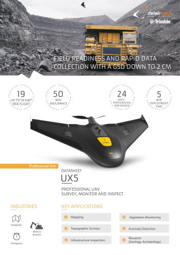
- UX5 HP PROFESSIONAL UAV SURVEY, MONITOR AND INSPECT
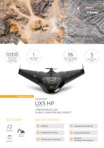
UX5 HP PROFESSIONAL UAV SURVEY, MONITOR AND INSPECT

UX5 HP PROFESSIONAL UAV SURVEY, MONITOR AND INSPECT
- Vegetation Monitoring
- Mapping
- Infrastructure Inspection
- Anomaly Detection
- Topographic Surveys
- Research (Geology, Archaeology)
- Geospatial
- Mines & Quarries
- Emergency Services
- Resolution: 36 Mpix, mirrorless full frame camera with custom lenses (15, 25, or 35 mm)
- GNSS Receiver: L1/L2 GNSS, 20 Hz (GPS, GLONASS, BeiDou, Galileo ready)
- Wind Resistance: Up to 55 km/h, moderate rain
- Altitude: Ceiling up to 5000 m
- Landing Space: Typically 20 m x 6 m, recommended 50 m x 30 m
- Endurance: Up to 35 min
- Weight: 2.5 kg (payload included)
- Wingspan: 1 m
- Material: EPP foam, carbon frame structure, composite elements
- Deployment Time: 5 min
- Cruise Speed: 85 km/h
- Take-off/Landing: Catapult (30 degrees) / Belly (14 degrees)
- Flying Range: 60 km
- High image acquisition quality and data accuracy with Trimble GNSS receiver and PPK GNSS technology
- All-weather and all-terrain operational performance
- Precise landings with reverse thrust technology
- Accessible technology with intuitive workflow using Trimble Business Center and Delair-Stack® software
- Analytics compatible with Delair-Stack®, ESRI ArcGIS, QGIS, Surpac, GlobalMapper, AutoCAD, PLS-CADD
- Available analytics include Ortho Image, DSM, Contour Lines, Cross Sections, Elevation Profiles, Stock Pile Volume Calculation, Vegetation Encroachment, Anomaly Detection
- Raw data compatibility with Delair-Stack®, Trimble Business Center, and photogrammetry software
- 0.52 km² mapped with 1 cm GSD at 75 m AGL
- 1.2 km² mapped with 2.1 cm GSD at 150 m AGL
- 7.8 km² mapped with 10.5 cm GSD at 750 m AGL
Catalog excerpts
UX5 HP PROFESSIONAL UAV SURVEY, MONITOR AND INSPECT INDUSTRIES KEY APPLICATIONS Mines & Quarries
Open the catalog to page 1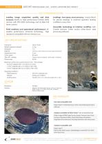
Professional line UX5 HP: PROFESSIONAL UAV - SURVEY, MONITOR AND INSPECT KEY DIFFERENTIATORS Leading image acquisition quality and data accuracy thanks to high performance Trimble GNSS receiver with PPK GNSS technology and 36 Mpix full frame camera. Field readiness and operational performance: allweather performance, all-terrain technology, high resistance compatible with an intensive use. Landings - less space, more accuracy - reverse thrust for precise landings in confined spacesfor landing confidence every time. Accessible technology & intuitive workflow with Trimble Business Center and/or...
Open the catalog to page 2All DELAIR-TECH catalogs and technical brochures
 Delair UX11
2 Pages
 Sat bear
2 Pages
 Mama bear Antenna
2 Pages
 DT-Eye X
2 Pages
 DT-Eye
2 Pages
 DT-5Bands
2 Pages
 DT-4Bands
2 Pages
 DT-3Bands
2 Pages
 DT26X-PPK
2 Pages
 DT26X-Lidar
2 Pages
 DT18
DT182 Pages
 White-paper-DT18-PPK
15 Pages
 White-paper
10 Pages
 DT26X
DT26X2 Pages
 DT26M
DT26M2 Pages