1. Catalogs
  2. DELAIR-TECH
  3. DT18 AG LONG-RANGE MINI UAV SURVEY, MONITOR & INSPECT
video corpo

DT18 AG LONG-RANGE MINI UAV SURVEY, MONITOR & INSPECT

DT18 AG LONG-RANGE MINI UAV SURVEY, MONITOR & INSPECT

DT18 AG LONG-RANGE MINI UAV SURVEY, MONITOR & INSPECT

Product catalog summary
Overview: The DT18 AG is a long-range mini UAV designed for surveying, monitoring, and inspecting large agricultural and forestry areas. It is capable of covering up to 1150 hectares per flight and is equipped with advanced sensors for precision agriculture.
Key Applications: The UAV is ideal for agriculture and forestry, including field research, microplots management, remote surveillance of crop practices, large-scale farms, plantations, herd scouting, precision agriculture, plant counting, gap detection, and forest characterization.
Specifications: The UAV features a MicaSense RedEdge Multispectral Camera with narrow and calibrated spectral bands (Red, Green, Blue, Red Edge, Near Infrared). It offers a ground sampling distance (GSD) down to 5 cm and can operate under various conditions, including wind resistance up to 50 km/h and moderate rain. The UAV has a communication range of up to 20 km and an endurance of up to 120 minutes.
Key Differentiators: The DT18 AG is noted for its high-quality crop data acquisition, quick return on investment, and safety features. It is the first UAV certified for daily BVLOS operations and includes advanced safety mechanisms like real-time front video and autopilot fail-safe systems.
Operating Conditions: The UAV can take off and land at altitudes from 0 to 2000 m ASL, with a ceiling of 2500 m ASL. It requires a landing space of typically 5 m x 10 m, with a recommended space of 10 m x 20 m.
Deliverables: The UAV provides analytics compatible with Delair-Stack®, ESRI ArcGIS, QGIS, ENVI, and eCognition. Deliverables include ortho images, DSM, DTM, NDVI, NDRE, MCARI, SAVI, plant counting, gap detection, plant height, field vectorization, vegetation height, and plant density maps.
Deployment and Material: The UAV is made from composite materials (fiberglass, carbon, kevlar) and can be deployed in 5 minutes. It is hand-launched or catapulted and lands on its belly to avoid crop damage. It has a cruise speed of 61 km/h.
See more

Catalog excerpts

DT18 AG LONG-RANGE MINI UAV SURVEY, MONITOR & INSPECT-1

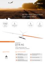
GET THE CROP STATUS RIGHT OVER LARGE AREAS Expert line LONG-RANGE MINI UAV SURVEY, MONITOR & INSPECT KEY APPLICATIONS Agriculture & Forestry Field Research & Microplots Management

 Open the catalog to page 1
DT18 AG LONG-RANGE MINI UAV SURVEY, MONITOR & INSPECT-2

Expert line DT18 AG: LONG-RANGE MINI UAV - SURVEY, MONITOR & INSPECT Best in class for crop data quality: the fully integrated, state of the art Agricultural sensor acquires data in 5 narrow bands (Red, Green, Blue, Red Edge, Near Infrared). Combined with the flight characteristics of DT18, it provides incomparable data quality. Quick return on investment (ROI): durable and reliable solution for intensive use, increase in produtivity thanks to better yields during data collection (multiple field mapping). Safe technology: first UAV certified in the world for daily BVLOS operations (since 2012)....

 Open the catalog to page 2

All DELAIR-TECH catalogs and technical brochures

  1. Delair UX11

    2  Pages

  2. Sat bear

    2  Pages

  3. DT-Eye X

    2  Pages

  4. DT-Eye

    2  Pages

  5. DT-5Bands

    2  Pages

  6. DT-4Bands

    2  Pages

  7. DT-3Bands

    2  Pages

  8. DT26X-PPK

    2  Pages

  9. DT26X-Lidar

    2  Pages

  10. DT18

    2  Pages

  11. White-paper

    10  Pages

  12. DT26X

    2  Pages

  13. DT26M

    2  Pages

*Prices are pre-tax. They exclude delivery charges and customs duties and do not include additional charges for installation or activation options. Prices are indicative only and may vary by country, with changes to the cost of raw materials and exchange rates.