- Catalogs
- DELAIR-TECH
- Delair UX11
Delair UX11

Delair UX11
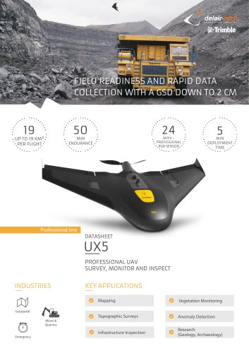
Delair's UAV is designed for large-area mapping with centimeter-level precision, offering optional PPK for survey-grade results. It is suitable for industries such as power & utilities, mining, construction, security, oil & gas, transportation, agriculture, and environmental conservation.
- Resolution: 1.7 cm GSD at 122m altitude
- GNSS Accuracy: Down to 1 cm
- Connectivity: 3G/4G
- Endurance: Up to 59 minutes
- Weight: 1.5 kg (payload included)
- Wingspan: 1.1 m
- Deployment Time: 5 minutes
- Cruise Speed: 54 km/h
- Take-off/Landing: Hand-launched, belly landing
- Operating Conditions: Wind resistance up to 45 km/h, moderate rain, temperature range -20 to 45°C
- Communication Range: Unlimited with 3G/4G within network coverage, up to 10 km with Delair Link
- GNSS: PPK optional, supports GPS+GLONASS
- Camera Sensor: Industrial-grade RGB, 21.4 Mpix, global shutter
The cloud-based platform allows for management, processing, and analysis of aerial data, providing insights through analytics such as ortho images, DSM, contour lines, and more.
Specifications are subject to change for improvements. Delair offers a software suite for PPK processing and data preparation for photogrammetry.
Catalog excerpts

STABLE & EASY-TO-USE Large-area mapping with centimeter-level precision and optional PPK for survey-grade results GNSS accuracy down to 1 cm PROFESSIONAL SMALL UAV, SURVEY AND MAP WITH EASE INDUSTRIES Minutes Endurance KEY APPLICATIONS Mapping & GIS Surveying Surveying & Mapping Mines & Quarries Power & Utilities Security & Defense Construction Environmental and Conservation Surface Mining Aggregates Public Land Management Agriculture & forestry Landfill Management
Open the catalog to page 1
KEY DIFFERENTIATORS Map large areas faster - One pilot can can map 9,6 km2 (3,7mi2) in an 8-hour day with 1,7 cm GSD at 122 m flight height. Industrial camera with optional PPK activation for survey-grade results. No need to sacrifice resolution for productivity when you can have both. BVLOS-ready communications - Dual-communication systems including WiFi radio link and mobile connectivity via 3G network (4G-ready) for unlimited range. Precise "birdlike" takeoff and landing (BTOL) high-angle (30 degrees) takeoffs and deep stall landings for use in confined areas, low-speed landing using distance-measurement...
Open the catalog to page 2All DELAIR-TECH catalogs and technical brochures
 Sat bear
2 Pages
 Mama bear Antenna
2 Pages
 DT-Eye X
2 Pages
 DT-Eye
2 Pages
 DT-5Bands
2 Pages
 DT-4Bands
2 Pages
 DT-3Bands
2 Pages
 DT26X-PPK
2 Pages
 DT26X-Lidar
2 Pages
 DT18
DT182 Pages
 White-paper-DT18-PPK
15 Pages
 White-paper
10 Pages
 DT26X
DT26X2 Pages
 DT26M
DT26M2 Pages