- Catalogs
- ClearNav Inc.
- ClearNav Flight Computer Quick Reference Card
ClearNav Flight Computer Quick Reference Card

ClearNav Flight Computer Quick Reference Card
- Glider Settings: Options to select, add, and edit glider details such as ID, type, polar, ballast, and weight. Includes settings for best glide ratio and speed.
- Special Use Airspace: Configure horizontal and vertical warning margins, maximum permitted altitude, and SUA alarms. Options to load/unload SUA files and adjust audio alarm volume.
- Flight Recorder: Enter pilot and glider information, transfer flight logs, and make IGC declarations.
- Waypoints: Manage home field selection, load/unload waypoint files, and edit waypoints.
- Tools: Access GPS information, simulator settings, serial ports, diagnostics, and screen inversion.
- Personal Settings: Customize pilot names, final glide settings, map display options, units, and language preferences.
- Flight Data Display Options: Configure altitude, task view, performance metrics, wind information, and voltmeter settings.
- Button Actions: Includes cursor movement, waypoint selection, zoom functions, menu navigation, and map focus.
- Basic Navigation: Map orientation, zoom levels, and airport/waypoint icons. Displays destination, distance, altitude difference, and wind information.
- Map Features: Red, purple, and green indicators for glide range and altitude considerations.
- Task Creation: Use the Ribbon Menu for task creation and control. Requires selection of task type, start/finish geometry, and waypoints.
- Task Action Screen: Controls active task functions and displays performance metrics. Allows for speed override entry.
- IGC Task Declarations: Make declarations prior to flight takeoff, including pilot and glider details. Changes require a new declaration.
Catalog excerpts
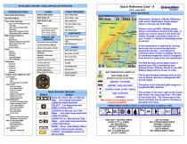
Edit Pilot Name Final Glide Settings AGL Arrival Height (Purple Amoeba) AGL Arrival Height (Red Amoeba) Show SUA Flyover Circle (Checkbox) MSL Altitude Map Display Options Tracks Map Items Waypoint Names/ Numbers Show SUA Color Fill (Checkbox) Focus Color_ Units Speed Distance Altitude Vertical Speed SUA Altitudes_ Language Deutsch English Espanol Francais Italiano_ FLIGHT DATA DISPLAY OPT ALTITUDES Pressure AGL 2nd Altimeter Feet MSL TASK VIEW Ground Speed Time Since Start Time To Finish Total Time Distance Achieved Distance To Go Speed Achieved PERFORMANCE Current Average Climb Flight Average Climb L/D to Destination L/D Current Glide STF Unit Type Ground Speed Local Time WIND Numeric Wind Direction Headwind Component TRACK AND BEARING Track/Bearing Bearing/Distance Track Error VOLTMETER Specify Threshold FLIGHT RECORDER Hand Controller Operation SETUP MENU OPTIONS / HAND CONTROLLER OPERATION PERSONALSETTINGS Select/Add Pilot Name Quick Reference Card (V4.0 - June 2012) Clearftav HIFTRUIHEDTJ BASIC NAVIGATION RIBBON MENU (Hit Menu Button on Hand Controller to display or hide) - (Distance Across Cursor Box) AIRPORT / WAYPOINT AIRPORT / NON-WAYPOINT • CONTROL POINT (START/FINISH) • NON -WAYPOINT Map airport icons display correct runway orientation. TASK EDIT / CONTROL MENU GLIDE TO TP or FINISH SET MacCREADY SELECT TURNPOINT SET % CLEAN SET % WATER BALAST SELECT WINDS Destination, Distance, Altitude Difference and current MacCready Values always show on the top row of the Map. Winds In Use and MSL Altitude always show in the bottom corners of the map. A single set of wind values in the lower left means ClearNav calculated winds are in use. A small 'c' indicates Cambridge winds are in use. A new destination is selected by moving the cursor box across the map (even beyond the border) - and hitting the controller Select button to display the list of contained waypoints. Select a waypoint from the list to make it the new destination. The Red Amoeba shows glide range to ground (zero AGL) considering your entered Polars, Altitude, Winds in Use, MC, Ballast, Bugs and the terrain in route. The Purple Amoeba indicates how far you can fly before reaching a designated AGL Arrival height. The green circle indicates glide range to a designated MSL Altitude. The number in the lower right of the Cursor Box shows the map scale level - the width of the cursor box. The Zoom keys on the hand controller can be used to increase or decrease this value. SET ALTITUDE SET SCREEN BRIGHTNESS THERMAL TRACKS ON-LINE CONTEST SETUP MENUS SET RIBBON MENU ITEMS
Open the catalog to page 1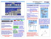
FLIGHT DATA DISPLAY OPTIONS The highlighted data boxes can be added to the top and bottom of the map using Personal Settings - Flight Data Display Options. Locations are fixed to stack like items - you cannot drag the boxes. Select only those required - to reduce clutter. Quick Reference Card - B ClCQfllCtY _(V4.0-June 2012)_msimnmt TASK SETUP/CONTROL The Ribbon Menu is the single entry point for all task creation and control functions. Tasks are created and controlled using the Ribbon Menu Task icon - the entry point to the Task Edit, Task Action, Task Map, and Task List screens. Task Edit (creation)...
Open the catalog to page 2All ClearNav Inc. catalogs and technical brochures
 ClearNav RAM Mount
1 Page
 ClearNav Extension Cable
1 Page
 ClearNav Flight Computer
32 Pages
 CNv Utility* (PC Install)
2 Pages


