- Catalogs
- C-Astral Aerospace
- Product Catalogue
Product Catalogue

Product Catalogue
Catalog excerpts

UNMANNED AIRCRAFT SYSTEMS
Open the catalog to page 1
C-ASTRAL Highlights C-Astral unmanned systems are much smaller than manned aircraft, easier to maintain and transport and therefore much more cost-effective, providing excellent productivity and fast return on investment. The industry leading BRAMOR UAS family is electrically powered and is able to achieve superior stability and endurance through its unique advanced Blended Wing Body airframe aerodynamics. It is capable of achieving the most precise surveying results in the small UAS category down to 0,6 cm, with a Ground Sampling Distance that starts at 0,7 cm. MANUFACTURED FROM ADVANCED AERODYNAMICS...
Open the catalog to page 2
C-ASTRAL Applications THE ULTIMATE SOLUTIONS FOR YOUR MISSION. ppX SURVEYING AND REMOTE SENSING INFRASTRUCTURE CONTROL PRECISION AGRICULTURE Point cloud derived DSM, DEM, Aerophotogrammetry, mapping, surveying, volume calculations and estimations. Roads and railroads management and control, critical infrastructure monitoring, pipeline and well monitoring, upstream, midstream and downstream monitoring. Vigor and health of crops, yield estimation, crop counting and volume calculations, chemical management, plant deconvolution. Target tracking, coordinate estimation, tactical level observation,...
Open the catalog to page 3
BRAMOR ppX GNSS SURVEY GRADE RECEIVER FEATURES ≥ Accuracy down to 0,6 cm ≥ Command, Control & Communications ≥ Real-time system health monitoring ≥ 100% Autonomous ≥ Exchangeable sensors ≥ Imaging control computer SURVEY GRADE IMU *OPTIONAL
Open the catalog to page 4
BRAMOR ppX Sensor Options 3,5h multiSensor 150km 15km2 cat para GNSS SURVEY GRADE RECEIVER ^ Post Processing Kinematic ^ Integrated |MU*optional ^ L1&L2 (L5 ready) GNSS receiver ^ Fast initialization ^ RTK datalink independent ^ Accuracy down to 0,6 cm “We would not have been able to map more than 300 km of a remote railway line in Ethiopia in a week without Bramor's capability to acquire data without a preplaced grid of ground control points.“ \ JAN ZOREC, KOBALE SURVEYING SERVICES \ LONG RANGE DATA LINK ANTENNAS —L» INTEGRATED SENSOR (MULTIPLE OPTIONS) ♦ C-ASTRAL ♦ * BRAMOR ppX *...
Open the catalog to page 5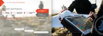
C-ASTRAL Pilot C3P Software WORKFLOW PHASES MISSION PLANNING FLIGHT & DATA COLLECTION ONLINE FLIGHT LOGBOOK DATA & IMAGE EXPORT C-ASTRAL PILOT C 3P SOFTWARE DATA PROCESSING COMPATIBLE WITH ≥ Ergonomic touch screen GUI ≥ Critical flight control data always present on screen ≥ Seamless and fast mission planning ≥ In-flight systems monitoring ≥ Area, mission time, GSD and precision estimation ≥ Failsafes management ≥ System health monitoring ≥ Real-time camera feedback ≥ 3D SURVEY ≥ ENSO MOSAIC ≥ AGISOFT PHOTOSCAN ≥ PIX4D MAPPER ≥ PIENEERING ≥ MENCI SIMPLE FLIGHT PLANNING FUNCTIONAL GUI MODES REAL-TIME...
Open the catalog to page 6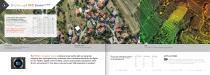
LAND SURVEY WITH THE HELP OF AN UNMANNED AERIAL VEHICLE (UAV) WITH 3DSURVEY Whitepaper by Vid Petrman, Modri Planet d.o.o. Ljubljana, Slovenia Email: [email protected] Bramor ppX accuracy assessment resulted in the mean error for X/Y = 6 mm and for Z = 24 mm. 24,3 MP RGB Map a large area in a single flight with high precision lenses. Ground Sampling Distance down to 0,7 cm. CONTOUR LINES Generate contour lines from pointclouds. DSM Generate high precision Digital Surface Model from your RGB dataset. The RGB 24,3 megapixel sensor enables precise visible light survey grade mapping, aero-photogrammetry...
Open the catalog to page 7
Map a large area in a single flight with high precision lenses. High-res Digital Surface Model. Multiple NIR band filters available. Multiple IR band filters available. Normalized Difference Vegetation Index is an index for visualizing Ground Sampling Distance down to 0,7 cm. vegetation health. The NDVI reveals variability in plant vigor and biomass, often times not visible in standard RGB color imagery. The 24,3 CIR/NDVI sensor is suitable for data acquisition in the NIR spectra, which can be processed into NDVI and eNDVI products. With the sub-centimeter GSD, single...
Open the catalog to page 8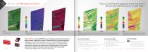
Bramor ppX Multispectral sensors “This is a revolutionary vegetation vision instrument. We can map 1500 hectares in a single flight.” Red Green Blue: This is a true color representation of the studied (field) area. Digital Surface Model can be used to visualize changes in topography or measure the height of plant / tree above the surrounding terrain. Color Infrared (or Near Infrared) layer helps you to visualize the amount of infrared light reflected. Normalized Difference Vegetation Index is an index for visualizing vegetation health. Areas with NDVI values greater than 0,5 are colored using...
Open the catalog to page 9
“The world’s smallest and most lightweight system with a functional hyperspectral camera.” The gHY sensor creates 2D spectral information in VIS-VNIR spectral range with single exposure and enables mosaicking with photogrammetric software. The sensor provides real response in each pixel without interpolation. This high end sensor is, due to it’s spectral range, especially suitable for uses in agriculture, forestry and water research for unrivaled results and precision. Hyperspectral imager VIS-VNIR snapshot F-number: ~ 2,8 Focal length: 9 mm Ground pixel: 6,5 cm at 100 m altitude Default spectral...
Open the catalog to page 10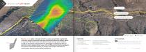
Bramor ppX gAS Sensor PIPELINE NETWORK UAV DATA ACQUISITION TRAIL GAS PLUME DISTRIBUTION PREDICTION GAS ‹ 5ppm The gAS sensor option on the ppX aircraft is a unique an extremely capable high resolution, excellent selectivity long range methane leak detection system, based on a proven DFB tunable diode laser absorption spectroscopy system adapted to UAS use from larger manned platforms. Developed in collaboration with gas detection industry leaders Boreal Laser and C-ASTRAL partners Ventus Geospatial, this system revolutionizes pipeline, oil and gas well and other methane and noxious gases detection...
Open the catalog to page 11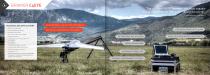
“The Ultimate C4ISR Solution – the most capable and affordable small UAS in its class in the world!“ A NATO OPERATIONS C-ASTRAL USER IN OPERATIONAL USE ON FOUR CONTINENTS ≥ Wildfire management ≥ Environmental monitoring BATTLEFIELD AND SPECIAL OPS PROVEN ≥ Infrastructure control ≥ Over the hill observation (LOS) ≥ Night surveillance RETRACTABLE EYE-X SENSOR ≥ Long range (40 km) data/video link ≥ Fire control ≥ Civil defense ≥ Target detection and tracking MODULAR AIRFRAME ≥ Low intensity conflict zone control ≥ Search and rescue missions ≥ EncryptionOPTIONAL ≥ MANET (Mobile Ad Hoc Network) and...
Open the catalog to page 12All C-Astral Aerospace catalogs and technical brochures
 astral_2018_katalog_feb
21 Pages