Catalog excerpts

Panel-mounted and portable at the same time! Even when cockpit-installed, to remove the EKP V from the plane to use it with the internal rechargeable battery for updates, flight planning or training school debriefing. Light and compact A brilliant 7” display, with removable battery and built-in GPS receiver, with a weight of just 400 gram, covering an area of only 110 x 172 mm and only 21mm thick! Much more than a moving map: navigation, EFB and PFD All you need in a single device, developed with safety in mind. Moreover, through the Cockpit Docking Station, EKP V can connect to: AvMap A2 ADAHRS, autopilot, weather receiver, traffic receiver, video camera and other instruments. Horizontal or vertical? Fully customizable! You can choose the Horizontal or Vertical orientation and you can change the layout choosing what to see and where to display it. You can set different aircraft profiles and even configure the F1 hard key. AvMap SATELLITE NAVIGATION
Open the catalog to page 1
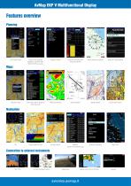
AvMap EKP V Multifunctional Display Features overview Planning Search in the Jeppesen database for Airports, VOR, NDB, INT, VFR rep. points Editable Checklist Flight Plan Vertical Profile (Plan up to 50 FP) Search and Rescue Patterns Search for a street address Select which data to display at every map scale Airport Diagrams Approach plates Custom charts import Airspace alarms NEAREST: search for the nearest airport Night vision Interactive maps Connection to external instruments Collision Avoidance system Weather (only in North America)
Open the catalog to page 2
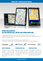
AvMap EKP V Multifunctional Display Moving map excellence: the most detailed maps, with the most reliable official data. AvMap maps are the result of 30 years of navigation technology and vector maps know-how. Our aeronautical maps include: Land elevation, Jeppesen database, Avioportolano, HERE Street maps, Airport Diagrams and Approach Plates. Additional VFR charts available: DFS ICAO Germany and IGN OACI France Five available coverages: Europe- Africa, North America, South America, Asia-Australia, Worldwide. ©IIVIOPoiMffiii Easy to read maps Following a visual approach procedure is very...
Open the catalog to page 3
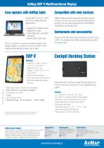
Easy updates with AvMap Suite Connect EKP V to the PC / MAC and use the AvMap Suite free application to: • Update EKP V software for free • Update EKP V maps • Import flight plans, user points and tracks • Import custom raster maps. EKP V is a product in continuous evolution thanks to free software updates; remember to connect your EKP V to the AvMap suite periodically to keep it up-to-date! Compatible with web seivices AvMap Software provides advanced planning functions, moreover, you can use the most popular flight planning services: you can import flight plans from RocketRoute...
Open the catalog to page 4All AVMAP S.r.l.U. catalogs and technical brochures
-
EngiBOX
2 Pages
-
Ultra EFIS
2 Pages


