LINAV Precision Navigation System

LINAV Precision Navigation System
- CPU: Intel Atom 1.6 GHz
- SATA Hard Drive: Flash 2 GB to 32 GB
- RAM: 1GB
- LCD Screen: 6.5” Full colour, sunlight readable, LED backlit
- Serial Ports: 4 x RS232
- USB Ports: 2 x USB 2.0
- Keypad: Electrometric tactile with 6 soft keys and 3 control keys
- Other: Remote Boom Switch
- Dimensions: 179 mm (W) x 134 mm (L) x 38.455 mm (H)
- Real-time 3D navigation program
- Pre-flight simulator and planning program
- Utilities for data upload/download
- Survey area setup and line direction definition
- Automatic flight line generation
- Four flying modes: Map, Grid, Line, Waypoints
- 3D guidance
The LiNav is a DGPS navigation system tailored for aerial surveys, providing swath and directional guidance. It includes a Moving Map Display, light bars for steering, and a DGPS receiver system compatible with OmniStar L-Band satellite differential or WAAS and/or Coast Guard Beacon.
- Super bright 6.5” backlit screen
- Obstacle and power line warnings
- Compatible with flow and gate control devices
- Material: Aluminum Alloy
- Mount: Chassis mount bracket, Adjustable Ram Mount
- Enclosure: Dust and splash proof
- Weight: 1.5 kg
- Input Voltage: 10-30 VDC (Reverse Polarity Protected)
- Operating Temperature: 14 °F to 149 °F (-10 °C to +65 °C)
LiNav uses a horizontal cross-track indicator for XY directions and a vertical bar for altitude. Horizontal navigation is based on a pre-defined Flight Plan, while vertical navigation uses a gridded image of the area. The system records flight paths and can import data into Geosoft for verification.
- Tie Lines of the survey area can be flown and GPS altitude data gridded using Geosoft.
- USGS 30 arc second digital elevation data can be used after gridding with Geosoft.
- Local digital elevation data converted into a Geosoft grid file can also be used.
30 Churchill Dr., Barrie, Ontario, L4N 8Z5
Email: [email protected]
Phone: 1 (800) 99-AGNAV
Fax: 705 734-0880
Website: www.agnav.com
Catalog excerpts

THE SOFTWARE FEATURES: • Real-time 3D navigation program • Pre-flight simulator and planning program • Utilities for uploading and downloading data • Set up survey area • Define line direction • Automatically generate flight lines to cover area • Rotate area in direction of flight • Four flying modes: Map, Grid, Line, Waypoints • 3D guidance LINAV Precision Navigation System The LiNav is a DGPS navigation system designed to meet the specific requirements for general aerial survey. The LiNav system provides the pilot with swath, directional guidance, and other navigational information required to carry out precise aerial applications. The LiNav consists of a compact, intelligent Moving Map Display with keypad, a choice of AG-NAV's light bars (steering indicators) to suit the application and type of aircraft, and a stand-alone DGPS receiver system. The LiNav system is used with a variety of DGPS receivers incorporating OmniStar L-Band satellite differential or WAAS and/or Coast Guard Beacon. LiNav uses the popular PNAV software with customized data output that has proven user-friendly and successful in general survey application. KEYFEATURES: • Super bright 6.5" backlit screen • Obstacle and power line warnings • Compatible with flow and gate control devices SPECIFICATIONS: CPU: Intel Atom 1.6 GHZ SATA Hard Drive: Flash 2 GB to 32 GB RAM: 1GB LCD Screen: 6.5” Full colour, sunlight readable, LED backlit Serial: 4 x RS232 serial ports USB (2.0): 2 x USB ports Keypad: Electrometric tactile keypad, 6 soft keys for program navigation, 3 control keys: on/off, brightness, up/down Other: Remote Boom Switch Dimensions: 179 mm (W) x 134 mm (L) x 38.455 mm (H) Material: Aluminum Alloy Mount: Chassis mount bracket Adjustable Ram Mount Enclosure: Dust proof and splash proof Weight: 1.5 kg Input voltage: 10-30 VDC (Reverse Polarity Protected) Operating Temp: 14 °F to 149 °F (-10 °C to +65 °C)
Open the catalog to page 1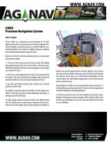
LINAV Precision Navigation System How It Works Theory: LINAV uses a horizontal cross-track indicator for XY (left/ right) directions and a vertical bar for the Z direction (altitude). Horizontal navigation is performed using a pre-defined Flight Plan as a horizontal reference. The vertical (or altitude) reference is obtained from a gridded (using Geosoft) image of the area. Reference Grid File: The reference altitude grid file can be generated using various methods. 1. Tie Lines of the survey area can be flown and the GPS altitude data gridded using Geosoft. This Tie Line Grid file can then be...
Open the catalog to page 2All AG-NAV catalogs and technical brochures
 Guia Platinum
2 Pages


- KENNAMETAL aeronautic software
- KENNAMETAL real-time software
- Generator
- GPU
- Aircraft start unit
- Runway start unit
- KENNAMETAL 3D software
- Mobile start unit
- Electric ground power unit
- KENNAMETAL navigation software
- AC/DC GPU
- Fixed generator
- Fixed GPU
- KENNAMETAL mapping software
- Battery-powered GPU
- Altimeter
- Flight planning software
- Aircraft altimeter
- Aircraft GPS
- Geolocation software