- Catalogs
- AERODATA AG
- Airborne Radio Interference Localization and Monitoring System AD-ARLOC II
Airborne Radio Interference Localization and Monitoring System AD-ARLOC II

Airborne Radio Interference Localization and Monitoring System AD-ARLOC II
- RF Spectrum Detection
- Direction Finder Antenna Array with 3 Frequency Bands
- DF Processor with Local Screen
- Fully Integrated Remote Control in AFIS Software
- Audio Output to Intercom System
The increasing use of radio frequencies leads to more conflicts and interferences. Traditionally, ground-based equipment is used to locate interference sources, which can be time-consuming and limited by access issues.
The AD-ARLOC II system allows for airborne identification, analysis, and localization of interference sources, offering a faster alternative to ground-based methods. It uses the AeroFIS® system to calculate the interference source's position using WGS84 coordinates.
The system analyzes the frequency spectrum using a digital spectrum analyzer, which is controlled remotely via AeroFIS® software. It identifies interference characteristics and uses a Direction Finder to provide continuous bearings to the interference source. The AeroFIS® software calculates the source's position using sophisticated algorithms.
The AD-ARLOC II is integrated into the AeroFIS® software, allowing remote control of the spectrum analyzer and direction finder, recording of data, and visualization in Google Earth.
- Direction Finder: Processor, antenna coupler, and array
- Spectrum Analyzer: Existing or new installation, with various antennas
Advanced algorithms are used for fast localization, correcting errors and considering signal quality. The system rapidly converges to reliable coordinates due to the changing geometry between the aircraft and the interference source.
Pilots can use the AeroFIS® interface for autopilot-guided search patterns, with DF bearings displayed in the cockpit.
The AFIS software displays the flight track and bearing results on a map, with data exportable to other mapping services like Google Earth.
Catalog excerpts

aerodata precision in special mission Key Features • RF Spectrum Detection! • Direction Finder Antenna Array with 3 Frequency Bands • DF Processor with Local Screen • Fully Integrated Remote Control in AFIS Software • Audio Output to Intercom System
Open the catalog to page 1
Challenge Today’s intensive use of the radio frequency spectrum by very different users creates more and more conflicts of radio signal interferences. Normally, if Radio Frequency Interference (RFI) is identified during flight inspection, the task of the flight inspection crew ends. A special trained ground crew is brought into place for the complex task of locating the RFI source. Typically this is performed by ground based equipment in fixed, portable or mobile installations. If the RFI analysis equipment must be transported to the area of interest first, this could take a lot of time. Another...
Open the catalog to page 2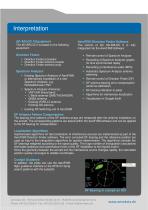
Interpretation AD-ARLOC II Equipment AeroFIS® Direction Finder Software The AD-ARLOC II is based on the following The control of the AD-ARLOC II is fully equipment: integrated into the AeroFIS® Software: • Remote control of Spectrum Analyzer • Recording of Spectrum Analyzer graphs for time synchronized replay • Recording of interference audio (MP3) • Automatic Spectrum Analyzer antenna switching • Remote control of Direction Finder (DF) • DF antenna bearing error compensation (antenna calibration) • DF bearing indication to pilots • Algorithms for interference localization • Visualization in...
Open the catalog to page 3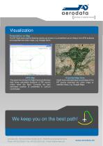
Visualization Presentation on Map The DF flight track and the bearing results are shown on a simplified Lat/Lon Map in the AFIS software and exported into other maps, e.g. Google Earth. The green line shows the flight track and the blue dots show calculated locations of RF source online while the flight. Currently the best estimated position is presented in Lat/Lon coordinates. Flight track and estimated coordinates of the RF source exported into other maps or satellite views, e.g. Google Maps We keep you on the best path! Aerodata AG ∙ Hermann-Blenk-Straße 34-36 ∙ 38108 Braunschweig/Germany...
Open the catalog to page 4All AERODATA AG catalogs and technical brochures
 RNAV FI System AD-RNAV
4 Pages
 AeroFIS®
8 Pages
 RNAV FI System AD-RNAV
4 Pages
 PRICE LIST 2017
8 Pages
 VIS Line Scanner
2 Pages


- Inspection machine
- Inspection machine for the aeronautical industry
- Surveillance radar
- Aircraft camera
- Laser scanner
- Aeronautic laser scanner
- Aircraft radar
- Airborne radar
- Flight management system
- Aircraft flight management system
- Optical inspection machine
- Contact laser scanner
- Radio direction finder
- Digital radio direction finder
- Aircraft radio direction finder
- Aircraft engine inspection machine