
カタログの抜粋
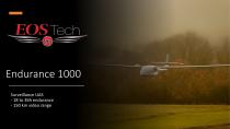
Endurance 1000 Surveillance UAS - 18 to 36h endurance - 150 km video range
カタログの1ページ目を開く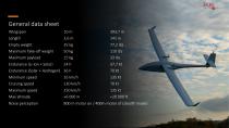
General data sheet Wingspan Empty weight Maximum Take-off weight Maximum payload Endurance (Li-Ion + Solar) Endurance (Solar + Hydrogen) 36 h Minimum speed Cruising speed Maximum speed Noise perception 800 m motor on / 400m motor of (stealth mode)
カタログの2ページ目を開く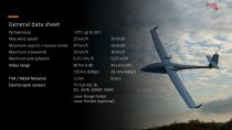
General data sheet Temperature Maximum Launch / recover winds Maximum crosswinds Maximum precipitation Video range Electro-optic sensors TV Full HD, IR, EO, LWIR, MWIR, SWIR Laser Range Finder Laser Pointer (optional)
カタログの3ページ目を開く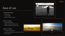
Ease of use Low logistical footprint: • 30m off-road runway or catapult Minimum training: • 2 weeks operator training Programmed waypoints, Racetrack mode Flight plan modification during the mission Maximum reliability: • Twin engines for mission safety Automatic take-off & landing , automatic Return To Home
カタログの4ページ目を開く
36h endurance : solar + Hydrogen-electric • STORAGE BAR CYLINDERS • • • • Est. Total Electrical Energy Capacity 3020Wh Total Weight 3.6Kg With pressure regulator Certification EN 12245 • AIR-COOLED PEM FUEL CELLS • • • • Rated power 1000W Peak power 1300W Current range 0-35A (10s) Hybrid LiPo 10S Refill your high-pressure storage system at any moment in the field 34 bar minimum input pressure < 63 dB noise during operations AIR-COOLED PEM FUEL CELLS 194x127x193mm // 1.8Kg
カタログの5ページ目を開く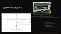
Only 2 operators to carry the case
カタログの6ページ目を開く
Landing gear or catapult Landing gear • 30 m off-road runway (for take-off & landing) 3 wheels landing gear for better stability Catapult data sheet : • Portable Pneumatic Catapult 26 m/s maximum launch speed Simple and quick assembly Smart safety features Packed size : Two cases, each (1313 x 704 x 543 mm) • Packed weight : 55 + 90 kg (121.3 +198.4 lbs) Take-off w
カタログの7ページ目を開く
Giro stabilized gimbal 1 Temis M 25 Weight Laser pointer Better than <150 micro rad Optical zoom Optical zoom
カタログの8ページ目を開く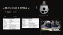
Giro stabilized gimbal 2 Orca 220
カタログの9ページ目を開く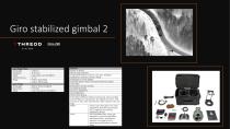
Giro stabilized gimbal 2 Orca 220
カタログの10ページ目を開く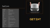
SatCom fully integrated (including BUC and Modem) fully ruggedized satcom terminal
カタログの11ページ目を開く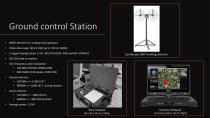
Ground control Station • MESH Network for multiple UAS operators Video data range: 80 km (HD) up to 150 km (640p) Twin frequency and modulation : • 2472Mhz (OFDM, 20M0 D2W) • 869.55Mhz (FM duplex, 50K0 F2D) Ground antenna : • 2472Mhz => 17dBi (23°) • 869Mhz => 12dBi (41°) during rotation Aerial antenna : • 2472Mhz => 3dBi (Omni) • 869Mhz => 3dBi (Omni) fixed Very compact Continuous 360° tracking antenna Intuitive software
カタログの12ページ目を開く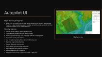
Autopilot UI Flight planning at fingertips • Make sure your flights are safe with terrain elevation and obstacle management features. It also includes our patent-pending tool which greatly optimizes the time required to follow curved linear networks Continuous 360° tracking antenna Planning features: • Display World imagery / World elevation map View obstacles (Power lines and Wind turbines) Plan using powerful large area and linear networks mapping tools Automatic overlap calculations Use our patent-pending linear networks following tool Export & Import KML/KMZ files Display flight path...
カタログの13ページ目を開く
Autopilot UI Flight monitoring at fingertips • Following aeronautic standards, our in-house flight monitoring software (“Aerostation”) automatically monitors all the flight parameters and ensures flight safety at all times. Once you have planned your mission with Aeroplanner, Aerostation will allow you to simulate, fly and even replay your missions. Continuous 360° tracking antenna Monitoring features: • Simulate your flights Replay your missions Ground proximity warning Automatic self-test & take-off checklist Interrupt and restart flight plans at any time Powerful alarm & warning system...
カタログの14ページ目を開く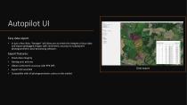
Autopilot UI Easy data export • In just a few clicks, “Aerogeo” will allow you to check the integrity of your data and export geotagged images with centimetric accuracy to subsequent photogrammetric post-processing software. Continuous 360° tracking antenna Export features: • Check data integrity Geotag your pictures Obtain centimetric accuracy with PPK GPS Compatible with all photogrammetric suites on the marke
カタログの15ページ目を開くEOS Technologieのすべてのカタログと技術パンフレット
-
 Strix 400
9 ページ