
カタログの抜粋

Drone mapping for digital agriculture Immediate digital scouting Multispectral crop protection analysis Zonation and prescription functionality
カタログの1ページ目を開く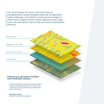
Turn drone images into action with state-of-the-art photogrammetry outputs designed especially for agriculture. Tackle challenges in the field by converting drone images to orthomosaics, digital surface models, vegetation index maps, zones and prescription maps to help you maximize operational efficiency. Digital surface model Enhance your agriculture workflow with Pix4Dfields software “Processing speed coupled with great analytics, creates a product that brings true value to the customers. No other software can achieve this level of efficiency.” Nicholaus Helwig Owner Pinpoint Aerial...
カタログの2ページ目を開く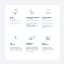
Flight planning Create flight plans with tailored missions to capture optimal data in the field. Import images from any standard RGB and selected multispectral cameras including Parrot Sequoia and MicaSense RedEdge. Transform drone images into accurate and actionable maps and achieve consistent and comparable results throughout the growing season. Fast mapping Operational efficiency Process imagery with the Pix4Dfields instant processing engine and achieve results in minutes in-office and in-field. Optimize your workflow with Pix4Dfields tools designed for agriculture such as the index...
カタログの3ページ目を開く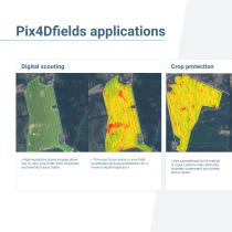
Pix4Dfields applications Digital scouting • High-resolution drone images allow you to view your fields from anywhere and identify issues faster. Crop protection • Trim your focus areas to your field boundaries and use annotations for a more in depth inspection. • Use a predefined list of indices or input custom index formulas to better understand your plants stress leve
カタログの4ページ目を開く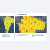
Crop production • Link different layers of information and easily compare crop trends over time in a split or a double screen. • Create custom zones with information from vegetation index maps. • Create comprehensive Application Rate Maps for a more targeted use of inpu
カタログの5ページ目を開く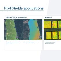
Pix4Dfields applications Irrigation and erosion control • Get more details about irrigation variability for better understanding of crop moisture levels. • Pinpoint erosion-prone areas with an elevation model of your field. • Generate custom indices specific to your cro
カタログの6ページ目を開く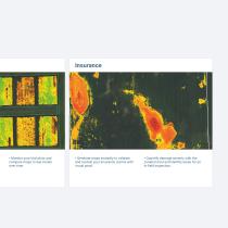
• Monitor your trial plots and compare maps to see trends over time. • Generate maps instantly to validate and sustain your insurance claims with visual proof. • Quantify damage severity with the zonation tool and identify areas for an in-field inspecti
カタログの7ページ目を開く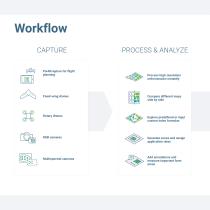
Workflow CAPTURE PROCESS & ANALYZE Process high-resolution orthomosaics instantly Fixed-wing drones Rotary drones Compare different maps side by side Explore predefined or input custom index formulas Generate zones and assign application rates Multispectral cameras Add annotations and measure important farm areas
カタログの8ページ目を開く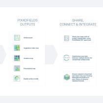
SHARE, CONNECT & INTEGRATE Share your maps with all project stakeholders using Pix4Dfields PDF report tool Synchronize your data between multiple devices for streamlined collaboration Digital surface model Choose outputs to download and import into your Farming Management Platform in your choice of industrystandard formats
カタログの9ページ目を開く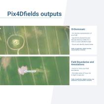
Pix4Dfields outputs Orthomosaic • An intuitive representation of your field • Specify the desired Ground Sample Distance (GSD) for a more or a less detailed output • Scout and identify issues faster Fields of application: digital scouting, crop protection, insurance Field Boundaries and Annotations • Import or draw your field boundaries • Annotate areas of focus for in-depth inspection Fields of application: digital scouting, crop production, crop protection, in
カタログの10ページ目を開く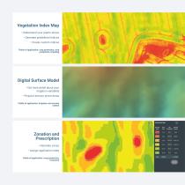
Vegetation Index Map • Understand your plants stress • Generate predefined indices • Create custom indices Fields of application: crop protection, crop production, breeding Digital Surface Model • Get more detail about your irrigation variability • Pinpoint erosion prone areas Fields of application: irrigation and erosion control Zonation and Prescription • Generate zones • Assign application rates Fields of application: crop production
カタログの11ページ目を開くDraganfly Dronesのすべてのカタログと技術パンフレット
-
 Infield assessment
4 ページ


