
Estratti del catalogo

Advanced Backscatter LIDARS (Aviation)
Aprire il catalogo a pagina 1
Big Projects New Challenges require New solution – Innovation Runway Visual Range (RVR) Raymetrics 3D scanning LIDARs can function as multi-purpose aviation tools 1. Visibility Provides Slant Visual Range (SVR) – more accurate reflection of pilot’s visibility compared to Runway Visual Range (RVR) 2. Scanning Ceilometer Provides 3D cloud base (total ceiling) instead of cloud height at a single point like a ceilometer (which is a basic LIDAR) Slant Visual Range (SVR) 3. Fog incoming bangs Detection for Better Forecasting Remotely detects incoming fog banks and indicates time of arrival –...
Aprire il catalogo a pagina 2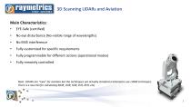
Runway Visual Range (RVR) Main Characteristics: • EYE-Safe (certified) No eye disturbance (No-visible range of wavelengths) Fully customized for specific requirements Fully programmable for different actions (operational modes) Fully remotely controlled Slant Visual Range (SVR) Note: LIDARs are “new” for aviation but the techniques are actually standard (ceilometers use LIDAR technique). There is a new ISO for calculating MOR, VOR, SOR, SVR,
Aprire il catalogo a pagina 3
Two major problems caused by haze: 1) Visibility reduction; 2) Health effects Visibility is generally used synonymously with “visual range”, meaning the farthest distance at which one can see a large, black object against the sky at the horizon. Some factors determining how far one can see through the atmosphere: (i) optical properties of the atmosphere; (ii) amount and distribution of light; (iii) characteristics of the objects observed; (iv) properties of the human eye. Visibility is reduced by the absorption and scattering of light by both gases and particles. However, light scattering...
Aprire il catalogo a pagina 4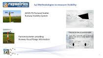
la) Methodologies to measure Visibility AGVIS FSI Forward Scatter Runway Visibility System Transmissometer providing Runway Visual Range information
Aprire il catalogo a pagina 5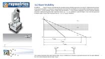
lc) Slant Visibility EXAMPLE Figure 3 shows schematically the situation during a landing approach at an airport. A light transmissometer at the ground (baseline xl) measures Fmor [Equation (5)] under the assumption of a horizontally homogeneous extinction coefficient m in this example, Fmor is larger than the baseline xl. Fsor requires integration over the vertically stratified extinction coefficient [Equation (8)]. Under low stratus (cq > m, <23) conditions, a pilot at height h, thus sees the ground at a steeper angle (Fsori) than in ground fog (m > 02, <23; FsoR2) conditions. The scheme...
Aprire il catalogo a pagina 6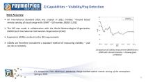
Data Accuracy An International Standard (ISO) was created in 2012 entitled: “Ground based remote sensing of visual range with LIDAR” - ISO number 28902-1:2012 The ISO was made in collaboration with the World Meteorological Organization (WMO) and International Civil Aviation Organization (ICAO) Raymetrics LIDARs conform to the ISO requirements LIDARs are therefore considered a standard method of measuring visibility – and can do so remotely Comparison of visibility measurement (MOR) from a LIDAR and a transmissometer – showing good correlation (*). Comparison Plots taken by C....
Aprire il catalogo a pagina 7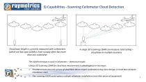
Runway Visual Range (RVR) Slant Visual Range (SVR) Cloud base height is currently measured with ceilometers (which are low-spec LIDARs). Each runway often has more than one ceilometer. A single 3D scanning LIDAR can measure total ceiling – cloud base in multiple locations The LIDAR technique is used in Ceilometers – identical principle Using a 3D Scanning LIDAR for cloud base measurement is advantageous in two ways: 1. Provides a more accurate picture of cloud base above airport (ceilometers may miss changes in cloud base between installation sites) 2. One scanning LIDAR could replace...
Aprire il catalogo a pagina 8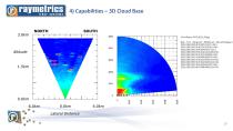
raymetrics lidar systems 4) Capabilities - 3D Cloud Base 3.0km
Aprire il catalogo a pagina 9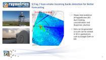
5) Fog / haze-smoke incoming banks detection for Better Forecasting Shows time evolution of fog/pollution (3D dust tracking, concentrations and dispersion, plumes) Data can be geocoded so scans can be viewed in 3D in applications such as Google Earth or GIS
Aprire il catalogo a pagina 10
5) Fog incoming banks Detection for Better Forecasting • 13:40:50 - Fog bang detected at 7150 meters • 13:45:50 - Fog bang detected at • 6450 meters In 5 minutes fog approached lidar more than 500 meters
Aprire il catalogo a pagina 11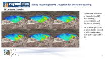
5) Fog incoming banks Detection for Better Forecasting Shows time evolution of fog/pollution (3D dust tracking, concentrations and dispersion, plumes) Data can be geocoded so scans can be viewed in 3D in applications such as Google Earth or GIS
Aprire il catalogo a pagina 12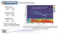
355nm Co-Polar Night: > 14 kmDay: > 12 km ATHENS, NTUA, LIDAR, RCS@1064nm, 21 - 22 APRIL 2010 15:35UTC - 8:58UTC, RESOLUTION 15m - 90sec 355nm Cross-Polar Night: > 12 kmDay: > 11 km VOLCANIC ASH Nitrogen Raman Night: > 12 kmDay: > 3 km 45004000350030002500200015001000- IMPORTANT: Values above are achievable with Signal to Noise Ratio (SNR) > 10 (i.e. very high quality data) Volcanic ash from the Eyjafjallajokull eruption in 2010 detected at heights of 10 km down to 5 km over a 12 hour period with a LIDAR built by Raymetrics for National Technical University of Athens (NTUA)
Aprire il catalogo a pagina 13
lidar systems First operational system installed for the National Environment Agency (NEA) FOR CHANGI AIRPORT in Singapore ’SELE.WR AIRPORT
Aprire il catalogo a pagina 14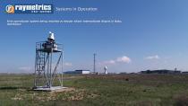
First operational system being installed at Heydar Aliyev International Airport in Baku, Azerbaijan
Aprire il catalogo a pagina 15Tutti i cataloghi e le schede tecniche RAYMETRICS SA
-
 3D Aerosol LIDAR
4 Pagine
-
 Aerosol LIDAR
3 Pagine
-
 customized LIDARs
5 Pagine