
Estratti del catalogo

Walnut Orchard Use Case Study How One Walnut Grower Realized Higher Yields
Aprire il catalogo a pagina 1
Putting aerial drone data analytics to work HOW ONE WALNUT GROWER REALIZED HIGHER YIELDS A walnut grower in Modesto, California had consistently received lower yields from the northern part of his field due to its sandy soil profile. Insights gained from drone data analytics allowed him to target inputs for increased canopy and yield. “Without these aerial images I probably would have not done anything to this orchard.” BILL BRUSH WALNUT GROWER Copyright © 2018 AeroVironment, Inc. - All rights reserved. AeroVironment, AV, Decision Support System, DSS and Quantix are trademarks of...
Aprire il catalogo a pagina 2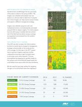
M E T H O D O L O G Y & O B S E R V AT I O N S AeroVironment and Bill began the two-year study of the walnut orchard in the spring of 2016. The imagery was collected and analyzed over two seasons on a 40-acre field to determine if analytics from drone imagery can help pinpoint areas of stress and support a different management strategy. Imagery was collected using true color and multispectral sensors, and subsequently processed using AV DSS for deeper insights. The initial analytics from the 2016 season revealed that the northern half of the field had less-dense canopy coverage and appeared...
Aprire il catalogo a pagina 3
via sprinklers. This allowed him to avoid over-application in the northern part of the field and avoid increasing nitrates in the groundwater table. By more efficiently allocating the water and nitrogen to targeted areas, the undernourished trees could finally perform to their full potential. Compared to 2016, the 2017 analytics revealed trees with improved canopy and less stress throughout the entire field. With balanced water and nitrogen applications, the orchard achieved healthier trees and larger canopy. Overall, Bill saw his yields increased by 21% which resulted in a profit increase...
Aprire il catalogo a pagina 4Tutti i cataloghi e le schede tecniche Draganfly Drones
-
 Mapping for Digital Agriculture
12 Pagine


