
Extraits du catalogue

3D Aerosol LIDAR Aviation | Mining | Meteorology LR111-ESS-D200
Ouvrir le catalogue en page 1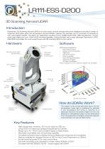
LR111-ESS-D200 3D Scanning Aerosol LIDAR Introduction Raymetrics’ 3D Scanning Aerosol LIDAR is an active laser remote sensing instrument designed to provide a variety of important information about the atmosphere. Aerosol LIDARs measure the particles, not of movement of particles as with wind Doppler LIDARs. This allows for applications including remote visibility (SVR, RVR, VOR), fog detection, remote cloud base height and more. With full 3D scanning capability, a powerful laser and a large telescope, Raymetrics’ LR111ESS-D200 is probably the most powerful eye-safe 3D scanning LIDAR on the...
Ouvrir le catalogue en page 2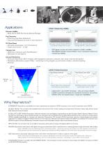
CASE 1: Measuring Visibility RVR Remote Visibility • SVR, RVR, VOR (Vertical Optical Range) Fog Detection • Incoming fog bank detection • Fog cannot bypass as with in-situ sensors 3D Cloud Base • Remote cloud base - for forecasting • Total cloud cover - in 3D Runway Visual Range (RVR) is currently measured in-situ Volcanic Ash • Definitive volcanic ash identification • Altitudes of ash layers LIDARs can provide Slant Visual Range (SVR) - pilot’s visibility SVR gives a more accurate measure of pilot’s visibility ISO 28902-1:2012 means LIDAR is now a standard method of measuring visibility...
Ouvrir le catalogue en page 3
*Effective ranges depend on atmospheric conditions and integration times. Raymetrics S.A. 32 Spartis, Metamorfosis 14452, Athens, Greece T +30 210 6655860 F +30 210 2827217 ■ www.raymetrics.com info@raymetrics.com
Ouvrir le catalogue en page 4Tous les catalogues et fiches techniques (PDF) RAYMETRICS SA
-
 Raymetrics-Aviation Presentation
15 Pages
-
 Aerosol LIDAR
3 Pages
-
 customized LIDARs
5 Pages