Extraits du catalogue
LuciadLightspeed Advanced geospatial analytics for desktop and onboard applications
Ouvrir le catalogue en page 1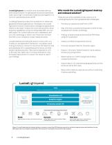
LuciadLightspeed is a modular and extensible desktop and onboard solution for geospatial situational awareness. Users can bring in a multitude of data sources together in a common operational picture (COP). LuciadLightspeed provides the foundations for advanced geospatial analysis applications. Developers can create high-performance C2 and location intelligence applications thanks to the clean, modular structure and powerful visual analytics capabilities. Using its configurable SDK, you can add support for custom data sources or databases, add your own symbology or match user interaction...
Ouvrir le catalogue en page 2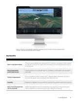
Figure 2: Starting in LuciadLightspeed’s application template Lucy, you can drag and drop your geospatial data, visualize it, add additional data layers and run analyses. Best-in-class performance Allows an unprecedented user experience with hundreds of thousands of track updates per second, on-the-fly line of sight (LOS) calculations and real-time data access without pre-processing Retained geospatial positioning accuracy Ensures precision on a worldwide scale for visualization, transformation and calculation of any data Platform independence Runs on all platforms (with or without GPU —...
Ouvrir le catalogue en page 3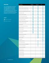
Overview The LuciadLightspeed components have been organized into product tiers. Depending on the needs of your organization, you can opt for LuciadLightspeed Essential, Advanced or Pro. From the Advanced and Pro tiers, you can extend the functionality available to you with extra options. Functionality Core GIS engine Projection, datum and geoid models Transformation and projection engine 4D cartesian and geodesic geometry model Unified data model CPU 2D visualization engine GPU 2D/3D visualization engine Vertical, profile and timeline views Feature included Customizable symbology Optional...
Ouvrir le catalogue en page 4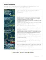
Functional specifications Below is a high-level, non-exhaustive overview of the functionality available in LuciadLightspeed. You can use the functionality it offers out of the box or extend it to meet user-specific requirements. Projection, datum and geoid models Transformation and projection engine 4D cartesian and geodesic geometry model Unified data model CPU 2D visualization engine GPU 2D/3D visualization engine Vertical, profile and timeline views Customizable styling • Model any data format, represent all object geometries and their metadata (standard or specific for your application...
Ouvrir le catalogue en page 5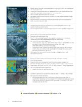
Visual analytics High-quality, largeformat printing Vector connectors Point clouds and reality meshes Access data in many vector and raster formats Exploits multi-leveling and tiling Benefit from LuciadLightspeed’s data-agnostic visualization and analysis capabilities, which are complementery with any data format Get out-of-the-box native support for: • Raster data: BIL, Bing Maps, BMP, DTED, ESRI TFW and JGW, ETOPO, GeoTIFF and BigTIFF, GIF, JPEG, JPEG2000, MapInfo TAB, PNG, PPM, USGS DEM, MBTiles and Open Street Map • Vector data: CGM, Collada, ESRI Shape, GeoJSON, MapInfo MIF and MAP,...
Ouvrir le catalogue en page 6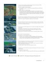
Advanced raster connectors Connect to and visualize specialized raster formats, and access a GDAL connector for several other raster formats Gain direct support for these formats: • ECW, GeoPDF, GeoSPOT, JPEG2000 (encoding), MrSID, Spot DIMAP and Swiss DHM Get GDAL support for these formats: • ARC/Info Binary Grid (AIG), BSB Nautical Chart Format, ARC/Info Export E00 GRID, ENVI HDR Labelled Raster, ERDAS Imagine, ERDAS Imagine Raw, ILWIS Raster Map, Intergraph Raster, PCI Geomatics database File, PCRaster, Sentinel 1 SAR SAFE, Sentinel 2, SAR CEOS, SRTM HGT, GDAL Virtual, ASCII Gridded XYZ...
Ouvrir le catalogue en page 7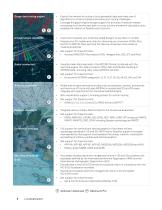
Graph and routing engine Infrastructure standards Import and visualize your computer-aided designs to see them in context Prepare your 3D models and cities for streaming via conversion of OBJ, Binz and IFC to OGC 3D Tiles; optimize the tiles via compresion and preserve material properties Get support for these formats: • Autocad DWG/DXF, Microstation DGN, Hexagon Binz, OBJ, IFC and Revit Visualize radar data captured in the ASTERIX format; combined with the real-time engine, the radar connector offers fast and flexible handling of ASTERIX data, including radar video (ASTERIX Cat 240) Model...
Ouvrir le catalogue en page 8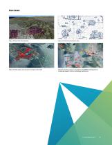
Figure 3: Real-time video draping Figure 4: 2D aeronautical chart data Figure 5: LOS analysis and dynamic routing on 3D terrain Figure 6: A tactical scenario visualized using APP6symbology shows LuciadLightspeed‘s military symbology capabilities.
Ouvrir le catalogue en page 9
Figure 7: Vessel plots combined with electronic navigational charts Figure 8: Dynamic aircraft tracks and trajectories combined with a timeline view LuciadLightspeed map Figure 9: Visual analytics on people movement data sets using spatial and non-spatial views Figure 10: 4D analysis of a NetCDF weather cube Figure 11: AIXM 5 data and flight plan preview in 3D and a vertical view
Ouvrir le catalogue en page 10
More information LuciadLightspeed comes with: • An automated installer and a launcher for applications, samples and documentation Build scripts and Maven POM files for all libraries Code samples for all components Developer’s guide with clear explanations and an overview of best practices API reference offering detailed descriptions of all interfaces and classes Release notes to see what’s new Technical notes to support technical requirements To learn more or schedule a demo, contact us at info.luciad.gsp@hexagon.com. For developer guides, code snippets, technical articles, videos and more,...
Ouvrir le catalogue en page 11
Hexagon is the global leader in digital reality solutions, combining sensor, software and autonomous technologies. We are putting data to work to boost efficiency, productivity, quality and safety across industrial, manufacturing, infrastructure, public sector and mobility applications. Our technologies are shaping production and people-related ecosystems to become increasingly connected and autonomous – ensuring a scalable, sustainable future. Hexagon’s Safety, Infrastructure & Geospatial division improves the resilience and sustainability of the world’s critical services and...
Ouvrir le catalogue en page 12Tous les catalogues et fiches techniques (PDF) HEXAGON METROLOGY SAS
-
 GeoMedia
12 Pages
-
 LuciadRIA
9 Pages
-
 LuciadFusion
14 Pages
Catalogues archivés
-
 Leitz PMM-C
16 Pages
-
 AT960
AT9602 Pages