
Katalogauszüge

RIEGL LiDAR in Forestry & Precision Agriculture Various LiDAR Sensors & Systems for Most Challenging Projects Based on most innovative and proprietary Waveform-LiDAR technology RIEGL laser scanners and systems provide an outstanding high-density point cloud ideally suited for applications in forestry and precision agriculture. Advanced processing algorithms account for a full exploitation of the information included in scan data. Multi-target capability enables excellent vegetation penetration and the computing of detailed terrain models. Point classification is the basis for growth monitoring, height modeling, or the detection of deadfall. WAVEFORM-LiDAR TECHNOLOGY RIEGL VQ-1560i-DW RIEGL VQ-1560 II(-S) High Performance 3D Terrestrial Laser Scanner Airborne LiDAR Scanning System for High-Point Density Mapping Applications Remotely piloted, fully integrated UAV-based Airborne LiDAR System RIEGL VQ-480 II / VQ-580 II Airborne Laser Scanning System for use in small aircrafts, helicopters, or large UAVs RIEGL UAS-based LiDAR Sensors for integration in the RiCOPTER and various types of renowned UAVs
Katalog auf Seite 1 öffnen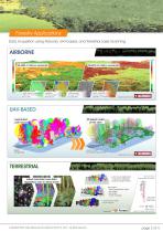
Forestry Applications Data Acquisition using Airborne, UAV-based, and Terrestrial Laser Scanning vegetation mask green: areas of vegetation higher than 3m and larger than 10 sqm canopy model vegetation colored by height above ground single tree deliniation colors represent the area covered by a single tree crown coverage terrain colored by the percentage of vegetation coverage UAV-BASED segmented point cloud display of single trees 3D piped model of tree stem volume model for biomass measurement created with LIS Pro 3D by TERRESTRIAL robust automatic scan data registration even in dense...
Katalog auf Seite 2 öffnen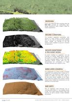
Due to the extremely high scanning rates the VUX®-1UAV provides an outstanding highdensity pointcloud, which makes it ideal for forestry applications. The excellent vegetation penetration rate results in a high number of ground returns that can be used to generate very detailed terrain models. The sample to the left depicts points classified as ground coloured by reflectance. GROWTH MONITORING & TREE HEIGHT MODEL g l rin e ito od on m m ht th eig ow h gr tree & All points classified as vegetation can be coloured by relative height above ground. This results in a relative estimation model of...
Katalog auf Seite 3 öffnen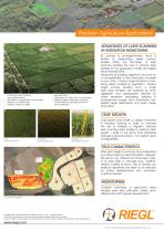
Precision Agriculture Applications ADVANTAGES OF LASER SCANNING IN VEGETATION MONITORING • ontinuous crop monitoring c during growth period • observation of irregularities in plant growth • detection of hail damage • analysis of terrain changes • yield estimation • observation of nutrient over- or undersupply • ongterm regular observation of growth l characteristics for geological evalution and classification By contrast to photogrammetry, which is limited to determining Digital Surface Models (DSM), the technique of laser scanning enables the user to capture data suitable for the...
Katalog auf Seite 4 öffnenAlle Kataloge und technischen Broschüren von RIEGL LASER MEASUREMENT SYSTEMS GMBH
-
 RIEGL VQX-1 Wing Pod
4 Seiten
-
 RIEGL VQ-780 II-S
8 Seiten
-
 RiUNITE
4 Seiten
-
 RIEGL VUX-120
8 Seiten
-
 RIEGL VUX-240
6 Seiten
-
 RIEGL miniVUX-SYS
4 Seiten
-
 RIEGL miniVUX-1LR
4 Seiten
-
 RIEGL miniVUX-3UAV
6 Seiten
-
 RIEGL miniVUX-2UAV
4 Seiten
-
 RIEGL miniVUX-1UAV
4 Seiten
-
 RIEGL VUX-1UAV-22
6 Seiten
-
 RiCOPTER with VUX-SYS
4 Seiten
-
 RIEGL UAV Sensors & Systems
2 Seiten
-
 RIEGL VQ-840-G
6 Seiten
-
 RIEGL VQ-880-G II
6 Seiten
-
 RIEGL VQ-880-GH
6 Seiten
-
 PH-VUX
2 Seiten
-
 RIEGL VPX-1
2 Seiten
-
 RIEGL VP-1 with RIEGL VUX-240
2 Seiten
-
 RIEGL VP-1
2 Seiten
-
 RIEGL VUX-SYS
4 Seiten
-
 RIEGL VUX-1LR-22
6 Seiten
-
 RIEGL VQ-1560 II-S
10 Seiten
-
 RIEGL VQ-1560 II
10 Seiten
-
 RIEGL VQ-780 II
8 Seiten
-
 RIEGL LD05e-A30-PH67
5 Seiten
-
 LIS ALS Classification Plugin
2 Seiten
-
 RiPROCESS
4 Seiten
-
 RDBLib
2 Seiten
-
 RiCOPTER-M
2 Seiten
-
 RIEGL DR1560i
2 Seiten
-
 RiVLib
4 Seiten
-
 RiCOPTER
2 Seiten
-
 RiHYDRO
2 Seiten
-
 RiACQUIRE
4 Seiten
-
 RIEGL miniVUX-1DL
4 Seiten
-
 LD05-A20 and LD05-A40
7 Seiten
-
 LD05-A80
5 Seiten
-
 RIEGL VQ-580 II
6 Seiten
-
 RIEGL VQ-480 II
6 Seiten
-
 RIEGL VQ-1560i-DW
10 Seiten
-
 LD05e-A10
4 Seiten
-
 LD05e-HT
4 Seiten
-
 LD05-HTGF
13 Seiten
-
 LD05-A10GF
10 Seiten
-
 RiWaveLIB
2 Seiten
-
 BathyCopter
4 Seiten