
Catalog excerpts
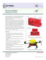
MicaSense RedEdge™ Multispectral Camera The MicaSense RedEdge™ is an advanced, lightweight, multispectral camera optimized for use in small unmanned aircraft systems. RedEdge™ provides accurate multi-band data for agricultural remote sensing applications. RedEdge™ is much more than just a camera, sharing more design features with Earth imaging satellites than it does with standard consumer cameras. Industrial imaging sensors provide high dynamic range in varying lighting conditions while removing artifacts commonly seen in drone video and imagery. Coupled with MicaSense Data Services, RedEdge™ provides a complete imaging, processing, and analysis system ready for integration with any platform. Need a closer look? Unplug your RedEdge™ and go handheld. An integrated shutter button lets you take close-ups of areas of interest, and with the optional GPS module, maintain geo-tagging and timestamping of all of your multispectral images. FEATURES • Simultaneous capture of five discrete spectral bands • Narrowband optical filters provide full imager resolution for each band • Fast capture rate enables faster flight speeds and lower flight altitudes Functional features of the RedEdge™ Camera • Global shutter design for distortion-free results on every platform • Single SD card stores all images with geotags • Calibrated for precise, repeatable measurements • Rugged design with no moving parts • Standalone operation, with optional external trigger and data from host aircraft • Intuitive web-based interface accessed from any Wi-Fi capable device • Option for Ethernet or serial connectivity with host aircraft for full configuration, status, and control of the camera Leptron Unmanned Aircraft Systems, Inc. 2650 East 40th Avenue Denver, Colorado 80205 Phone 303-384-3469 FAX 303-322-7242 www.leptron.com RedEdge™ Camera attached to a Leptron RDASS™
Open the catalog to page 1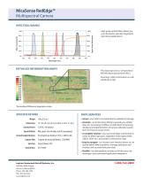
MicaSense RedEdge™ Multispectral Camera SPECTRAL BANDS High-grade optical filters deliver precise information specially targeted to agricultural applications. DETAILED INFORMATION MAPS This data map shows a vineyard from 400 feet above ground level (AGL). Zooming in offers information on individual plant vigor *Normalized Difference Vegetation Index SPECIFICATIONS Weight Dimensions • Secure - your data is encrypted during upload and storage. • Accurate - we do the heavy lifting to provide you reliable data. Our processing workflows include band-to-band registration and implementation of camera...
Open the catalog to page 2All Leptron Unmanned Aircraft Systems catalogs and technical brochures
-
 Leptron RDASS Precision
5 Pages
-
 Leptron RDASS HD
5 Pages
-
 Leptron Avenger™
2 Pages